Sgùrr nan Each facts for kids
Quick facts for kids Sgùrr nan Each |
|
|---|---|

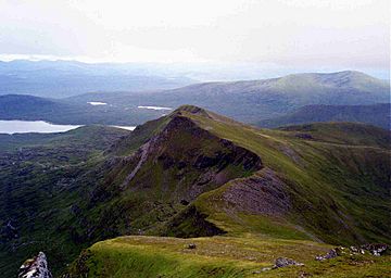
Sgùrr nan Each from Sgùrr nan Clach Geala, 2 km to the north.
|
|
| Highest point | |
| Elevation | 923 m (3,028 ft) |
| Prominence | 108 m (354 ft) |
| Listing | Munro |
| Naming | |
| English translation | Peak of the Horses |
| Language of name | Gaelic |
| Geography | |
| Location | Ross and Cromarty, Highland, Scotland |
| Parent range | Fannichs, Northwest Highlands |
| OS grid | NH184697 |
| Topo map | OS Landranger 20, OS Explorer 436 |
Sgùrr nan Each is a mountain in Scotland. It is part of a group of hills called the Fannichs. This mountain is about 27 kilometers (17 miles) south of Ullapool. It is located in the Highland area of Ross and Cromarty.
About Sgùrr nan Each
Sgùrr nan Each is not easy to see from main roads. It is deep inside the Fannichs mountain range. Other tall mountains often block the view. This mountain overlooks Loch Fannich, a large lake.
Sgùrr nan Each stands 923 meters (3,028 feet) tall. This makes it the 266th highest Munro in Scotland. A Munro is a Scottish mountain over 3,000 feet (914.4 meters) high. Its name comes from the Gaelic language. It means "Peak of the Horses."
Where is Sgùrr nan Each?
Sgùrr nan Each sits on a ridge that goes south. This ridge is part of the main Fannichs mountain line. The eastern side of this ridge is steep and rocky. Another higher Munro, Sgùrr nan Clach Geala, is about 2 kilometers (1.2 miles) north.
These two mountains are connected by a sharp ridge. Walking along it can involve some easy climbing. The lowest point between them is 815 meters (2,674 feet) high. The eastern side of Sgùrr nan Each drops steeply. There are cliffs leading down to the Allt a’ Choire Mhòir valley.
On the western side, the slopes are grassy. They gently go down to about 700 meters (2,300 feet). Then they drop sharply towards the top of Loch Fannich. To the south, the ridge continues over a smaller peak. This peak is called Sgùrr a' Chadha Dheirg. It is 866 meters (2,841 feet) high. From there, the land drops to the shores of Loch Fannich.
All the water from the mountain flows south into Loch Fannich. From there, it travels to the Cromarty Firth. This happens through the Grudie and Conon rivers. The mountain is mostly made of schist rock. This rock has shiny mica and quartz minerals in it.
The area around the mountain is special. It is a Site of Special Scientific Interest. It is also a Special Area of Conservation. This is because of its many bogs, marshes, and plants near the water. However, the area is mostly used for deer. You can often see herds of deer in the valleys and on the lower slopes.
How to Climb Sgùrr nan Each
Sgùrr nan Each is one of the smaller peaks in the Fannichs. People usually climb it with other hills in the group. The most common way to climb it is from the north. You can start from a parking area on the A832 road.
This route first takes you up Meall a' Chrasgaidh. Then you climb Sgùrr nan Clach Geala. After that, you continue south along the ridge to Sgùrr nan Each. You can also climb Sgùrr Mòr, the highest Fannich peak. This involves a side trip from the path between the first two Munros.
It is also possible to approach the mountain from the south. For this, you might need a mountain bike. You can ride about 15 kilometers (9 miles) to the base of the south ridge. This ride uses a special road from Grudie on the A835. The road is paved at first, then becomes a track. It passes Fannich Lodge before reaching the south ridge. From there, you can climb the mountain.
Years ago, people could drive a car closer to the dam. Some mountain guides suggest this southern route. It makes for a long day of hiking. You can visit seven of the Fannich Munros this way. There used to be a small shelter called the "Nest of Fannich" near the loch. It was helpful for climbers in the area. It is no longer there.
From the top of Sgùrr nan Each, the view to the west is amazing. You can see the Fisherfield Forest, Slioch, and the Torridon Hills.
 | Janet Taylor Pickett |
 | Synthia Saint James |
 | Howardena Pindell |
 | Faith Ringgold |

