Shady Dale, Georgia facts for kids
Quick facts for kids
Shady Dale, Georgia
|
|
|---|---|

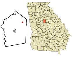
Location in Jasper County and the state of Georgia
|
|
| Country | United States |
| State | Georgia |
| County | Jasper |
| Area | |
| • Total | 0.89 sq mi (2.30 km2) |
| • Land | 0.89 sq mi (2.29 km2) |
| • Water | 0.00 sq mi (0.01 km2) |
| Elevation | 623 ft (190 m) |
| Population
(2020)
|
|
| • Total | 252 |
| • Density | 284.75/sq mi (109.95/km2) |
| Time zone | UTC-5 (Eastern (EST)) |
| • Summer (DST) | UTC-4 (EDT) |
| ZIP code |
31085
|
| Area code(s) | 706 |
| FIPS code | 13-69784 |
| GNIS feature ID | 0329643 |
Shady Dale is a small town located in Jasper County, Georgia, in the United States. In 2020, about 252 people lived there.
Contents
History of Shady Dale
Shady Dale was started around 1880. It was built on a spot where Creek Indian people once lived. The town was given the name "Shady Dale" because it described the area well.
The Georgia General Assembly, which is Georgia's main law-making group, officially made Shady Dale a town in 1889.
Geography and Location
Shady Dale is found in the northeast part of Jasper County. Its exact location is 33°23′58″N 83°35′24″W / 33.39944°N 83.59000°W. Two main roads, Georgia State Route 83 and Georgia State Route 142, meet in the middle of town.
- GA 83 goes northeast about 17 miles to Madison.
- GA 83 also goes southwest about 8 miles to Monticello, which is the main town of Jasper County.
- GA 142 goes northwest about 11 miles to Newborn.
- GA 142 also goes southeast about 9 miles to Willard.
The United States Census Bureau says that Shady Dale covers about 0.89 square miles (2.3 square kilometers) in total. A very small part of this area, about 0.33%, is water. Water on the east side of town flows into the Little River, which then joins the Oconee River. Water on the west side flows into Murder Creek, which is also part of the Little River system.
Population Changes Over Time
| Historical population | |||
|---|---|---|---|
| Census | Pop. | %± | |
| 1890 | 152 | — | |
| 1900 | 300 | 97.4% | |
| 1910 | 344 | 14.7% | |
| 1920 | 294 | −14.5% | |
| 1930 | 243 | −17.3% | |
| 1940 | 159 | −34.6% | |
| 1950 | 253 | 59.1% | |
| 1960 | 201 | −20.6% | |
| 1970 | 190 | −5.5% | |
| 1980 | 155 | −18.4% | |
| 1990 | 180 | 16.1% | |
| 2000 | 242 | 34.4% | |
| 2010 | 249 | 2.9% | |
| 2020 | 252 | 1.2% | |
| U.S. Decennial Census | |||
The population of Shady Dale changes over the years. In 2000, there were 242 people living in the town. These people lived in 88 households, with 60 of those being families. By 2020, the population had grown slightly to 252 people.
Fun Events and Culture
Shady Dale is famous for its yearly professional rodeo. This exciting event happens on the first weekend of June every year since 1983. The rodeo is approved by the I.P.R.A./S.R.A. and brings in champion cowboys and cowgirls from all over the United States.
During the rodeo weekend, the whole town becomes lively with fun activities:
- There is a rodeo parade.
- People can enjoy a wagon train ride.
- A community festival takes place.
The rodeo event is put on by two Masonic Lodges from Jasper County: Walton No. 200 and Jasper No. 50. The money raised from the rodeo helps support various charities run by the Masons.
See also
 In Spanish: Shady Dale para niños
 | Madam C. J. Walker |
 | Janet Emerson Bashen |
 | Annie Turnbo Malone |
 | Maggie L. Walker |


