
Shebelle River facts for kids
Quick facts for kids Shebelle River |
|
|---|---|

Map of the Jubba/Shebelle drainage basin
|
|
| Countries | |
| Physical characteristics | |
| Main source | Ethiopian Highlands Robe Gerjeda, Ethiopia 2,326 m (7,631 ft) 7°13′12″N 39°27′59″E / 7.2201°N 39.4665°E |
| River mouth | Jubba River (occasionally) Jamame, Somalia 14 m (46 ft) 0°09′57″N 42°46′22″E / 0.1659°N 42.7727°E |
| Length | 2,714 km (1,686 mi) |
| Basin features | |
| Basin size | 295,900 km2 (114,200 sq mi) |
The Shebelle River is a very important river in East Africa. Its name, Webi Shabeelle, means "Leopard River" in the Somali language. This long river starts high up in the Ethiopian Highlands in Ethiopia. From there, it flows southeast, making its way into Somalia.
As it gets closer to the city of Mogadishu, the river takes a sharp turn. It then flows southwest, following the coastline. After Mogadishu, the Shebelle River changes. It becomes a seasonal river, meaning it doesn't always have water. Most years, the river dries up before it can reach the Jubba River or the ocean. But when there are very heavy rains, the Shebelle River can connect with the Jubba River and flow all the way to the sea.
Two important areas in Somalia, Middle Shebelle and Lower Shabeelle, are named after this river. This shows how important the Shebelle River is to the people and the land.
Contents
River Branches and Streams
The Shebelle River has many smaller rivers and streams that flow into it. These are called tributaries. Some of these tributaries flow all year round, while others only flow during certain seasons, especially after heavy rains.
Here are some of its tributaries:
- Erer River
- Galetti River
- Wabe River
There's also the Fafen River. Usually, the Fafen River's water dries up before it can reach the Shebelle River. It only connects to the main river when there's a lot of rain.
River's Past: How People Used It
The Ajuran Empire and the River
Long ago, during the Middle Ages, a powerful group called the Ajuran Empire controlled the Shebelle River. This was around the 13th century AD. The Ajuran people were very smart about using water. They took control of the water from both the Shebelle and Jubba Rivers.
They were also excellent engineers. They built many wells and cisterns (tanks for storing water) out of limestone. Many of these old structures are still used today! The Ajuran rulers also created new ways to farm and collect taxes. Some of these methods were still used in parts of Africa even in the 1800s.
The Ajuran Empire was special because they controlled the water sources. This made them very powerful over people who moved around with their animals, known as nomadic people. They were like the only "water empire" in Africa at that time. The large wells they built attracted both Somali and Oromo nomads and their livestock. Having central control over the wells also helped solve arguments. People could go to government officials to help them settle disputes.
Trade was also very important. People had been trading across long distances in the Horn of Africa for a long time. This continued under the Ajuran Empire. Today, you can find many old, ruined towns in Somalia. These towns show that there was once a busy trade network far from the coast during the medieval period.
With the Ajuran Empire watching over things, farms near Afgooye, Bardhere, and other places along the Jubba and Shebelle rivers grew more food. They used a clever system of irrigation ditches, which locals called Kelliyo. These ditches took water directly from the Shebelle and Jubba rivers to the farms. Farmers grew crops like sorghum, maize, beans, grain, and cotton. They planted these during the gu (Spring) and xagaa (Summer) seasons of the Somali calendar. To help this system, they also built many dikes and dams. They even invented a way to measure land, using terms like moos, taraab, and guldeed.
The cities along the coast, like Mogadishu, Merca, Barawa, Kismayo, and Hobyo, became busy trading centers. Farmers from the inland areas along the Jubba and Shebelle rivers brought their crops to these coastal cities. There, local merchants sold the goods to traders from far-off places. Ships came and went from Arabia, Persia, India, Venice, Egypt, Portugal, and even as far as Java and China.
The River in Modern Times
Today, the area where the Shebelle River begins is farmed by different groups of people, including the Arsi Oromo, Sidamo, and mostly Somalis. The river's source is surrounded by a special area with juniper trees. In 1951, a Muslim member of the Arsi group protected this sacred place.
In 1989, with help from engineers from the Soviet Union, a large dam was built on the upper part of the Shebelle River. This dam, called the Melka Wakena dam, is in the Bale Mountains. It produces 153 megawatts of electricity, making it Ethiopia’s biggest hydroelectric power plant.
The Shebelle River has often caused flash floods in recent times. Before the 1960s, it was said to flood every other year. In the 1960s, there were two big floods: the hidigsayley in 1965 and the soogudud in 1966. In the 1970s, the kabahay flood in 1978 was very damaging.
In 1996, floods caused a lot of damage in three areas in Ethiopia. Then, on October 23, 1999, the river flooded suddenly in the middle of the night. It destroyed homes and crops in many villages in Kelafo and Mustahil areas. Local officials reported that 34 people and about 750 animals died. Around 70,000 people needed help because of the floods.
More recently, there was the dawdle flood in 2003, which swept away about 100 animals and 119 people. In April 2005, another flood trapped about 30,000 people. It also washed away 2,000 camels and 4,000 shoats (a type of goat). Some local people believe this was the worst flood in 40 years.
Images for kids
-
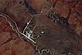
Astronaut photograph showing irrigation along the river


See also
- Geography of Ethiopia
- Geography of Somalia
- List of rivers of Ethiopia
 In Spanish: Río Shebelle para niños
