
Shirley, Southampton facts for kids
Quick facts for kids Shirley |
|
|---|---|
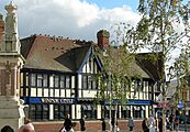
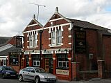
 Shirley High Street |
|

Shirley
|
|
| Unitary authority | |
| Ceremonial county | |
| Region | |
| Country | England |
| Sovereign state | United Kingdom |
| Post town | SOUTHAMPTON |
| Postcode district | SO15 |
| Dialling code | 023 |
| Police | Hampshire |
| Fire | Hampshire |
| Ambulance | South Central |
| EU Parliament | South East England |
| UK Parliament |
|
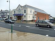
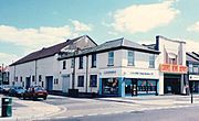
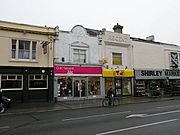
Shirley is a busy area and a former village located on the west side of Southampton, in Hampshire, England. Shirley is mainly known for its shops and homes. It is the most important shopping area outside the city centre on the west side of Southampton.
The homes in Shirley are a mix of council houses in the middle of the area and private houses. You can find larger suburban houses in Upper Shirley. Shirley is separated from Highfield by Southampton Common, which is a big green public park.
Contents
Shirley's Past
Shirley has a very long history. Tools from the Stone Age, like hand-axes, have been found here. These tools show that people lived in Shirley thousands of years ago. An adze head, another old tool, was also found from the New Stone Age.
The name Shirley means "bright clearing." It comes from old English words: scir (bright) and leah (cleared land in a wood). Shirley was mentioned in the Domesday Book, a famous survey from 1086. It was listed as a manor, which was like a large estate, with a mill. This mill was located where the Hollybrook and Tanner's Brook streams met.
Shirley Mill had three big ponds. One of these mill ponds still exists today. You can find it by following the Lordswood Greenway path. In 1228, the lord of Shirley, Nicholas de Sirlie, gave up some rights to Southampton Common. In return, he received a small payment. It was also agreed that people from Southampton could not use the land that later became Shirley Common.
In the 1800s, an iron works was built in Shirley. This factory was changed into a brewery in 1880. Later, in the early 1900s, it became a laundry. This laundry was owned by Royal Mail. It cleaned items for the mail ships that visited Southampton.
The stream from the mill used to flow across Romsey Road. Now, it runs underground through a large traffic junction. It continues to the River Test, sometimes flowing openly and sometimes underground. Another mill was built where Oakley Road and Tebourba Way meet today. This spot later became a paint factory. Some of the old mill buildings are still used by businesses today.
Shirley grew very quickly in the 1830s. This happened after Shirley Common was divided up and sold for building. In 1830, a newspaper announced that "Several elegant villas" (fancy houses) would be built on Shirley Common. In November 1830, workers in Shirley and Millbrook held a peaceful protest. They were asking for higher wages. The local church was built in 1836. In the 1960s, a council housing estate was built to replace older, more crowded homes.
Shirley used to be a small church district within the parish of Milbrook. On December 31, 1894, Shirley became its own separate civil parish. This meant it had its own local government. However, on March 31, 1912, Shirley became part of Southampton. In 1911, the parish of Shirley had over 33,000 people living there. Today, Shirley is part of the larger Southampton area.
Getting Around Shirley

In the late 1800s, there were plans to build a railway through Shirley. This railway would have gone to a new station near Southampton's Royal Pier. However, the railway line was only built as far as Winchester Chesil Station.
Old plans showed the railway continuing south through Shirley. It would have passed under Winchester Road and through land where Shirley Junior School is now. There is even a raised area of land near Hill Lane that was meant for the railway but was never used.
Some people thought that St James' Park, Southampton was going to be a local railway station. But old plans show the railway was meant to go northeast of the park. The large dip in the ground where St James Park is located was actually created later by digging for gravel.
Later, around 1901, there were new plans for a railway. This time, the railway was planned to go through St James' Park from east to west. Records show that property sales were discussed for this new plan. However, none of these railway plans ever happened in Shirley. They stopped before World War One.
From 1879, Southampton Corporation Tramways operated a tram route through Shirley. The tram ran from Southampton, along Fourposts Hill, and down Shirley High Street. More plans for the tram system were made in 1899. The tram service ran until 1949. It stopped at what is now the Shirley Precinct. Some local people still call this stop "Shirley Terminus" when they use the bus. A large tram depot was located in Carlisle Road. It was later used as a bus depot until it was taken down in the 1980s.
Learning in Shirley
Shirley is home to several schools. These include Upper Shirley High School, which used to be called Bellemoor Boys School. There is also Richard Taunton Sixth Form College. Its campus on Hill Lane used to be a Girls' Grammar School.
Shirley is also home to the 450-year-old King Edward VI School. The area is also served by Regents Park Community College, which was once Regents Park Girls School. The Atherley School, founded in 1924, was located on Hill Lane from 1926 to 1997. Shirley also has several schools for younger children, including infant and junior schools.
Places to Eat and Drink
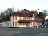
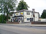
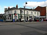
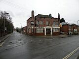
- Current and former public houses
-
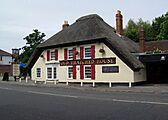
The Old Thatched House in Old Shirley
-
The Blacksmith's Arms, Old Shirley
-
The Brass Monkey, formerly the Rising Sun
-
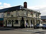
The Crown, Shirley High Street
-
The Salisbury Arms
-
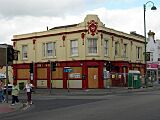
The Windsor Castle, Shirley High St
-
The Shirley
-
The Griffin, Anglesea Road
-
The King's Arms, Church Street


Old Cinemas
- Former cinemas
-
Atherley
-
Rialto, near the Atherley
-
Regent, Shirley High Street


Cemeteries in Shirley

Southampton Old Cemetery is located on the Shirley side of Southampton Common. You can find it on Hill Lane. This cemetery was created after a special law was passed in 1843.
Hollybrook Cemetery is a special place because several famous people are buried there. These include Alan Ball, a footballer who won the 1966 World Cup. The comedian Benny Hill is also buried there. Frederick Fleet, who was a lookout on the RMS Titanic, is also buried in Hollybrook Cemetery.
The Commonwealth War Graves Commission (CWGC) also looks after the Hollybrook Memorial here. This memorial remembers 1,883 soldiers and airmen from Commonwealth countries. They were lost at sea during World War I and do not have a known grave. Famous people listed on the memorial include Field Marshal Earl Kitchener. He was lost when his ship, HMS Hampshire, sank in 1916. Many members of the South African Native Labour Corps are also remembered here. They were lost when the ship SS Mendi sank in 1917.
The CWGC also cares for the graves of 113 Commonwealth service members from World War I. Most of these are in a special war graves section. There are also 186 graves from World War II. These include three sailors from the Merchant Navy who could not be identified. The cemetery also has 67 war graves from non-Commonwealth countries, mostly German soldiers.
Frederick Fleet, the Titanic lookout, was buried in a simple grave that had no headstone until 1993. That year, a headstone with a picture of the Titanic was put up. This was made possible by donations from the Titanic Historical Society.
Public Art in Shirley

Shirley, like many areas in Southampton, has some interesting public art. For example, there are several small mosaics created by a street artist named Will Rosie. These mosaics show characters from the popular Mr. Men and Little Miss books. These characters were created by Roger Hargreaves. You can even find an online map that shows where all these mosaics are located.
