Shriver Circle Earthworks facts for kids

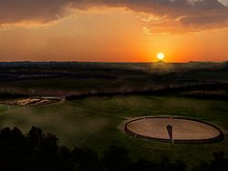
Artists conception of the summer solstice sunrise at the Shriver Circle Earthworks
|
|
| Location | Chillicothe, Ohio, |
|---|---|
| Region | Ross County, Ohio |
| Coordinates | 39°22′3.76″N 83°0′20.41″W / 39.3677111°N 83.0056694°W |
| History | |
| Founded | 200 BCE |
| Abandoned | 500 CE |
| Cultures | Ohio Hopewell culture |
| Site notes | |
| Archaeologists | Squier and Davis |
| Architecture | |
| Architectural styles | earthworks |
| Architectural details | enclosure, tumulus |
The Shriver Circle Earthworks (also called 33 RO 347) is an ancient site built by the Ohio Hopewell culture. This culture lived in the area from about 200 BCE to 500 CE. The site is located in Chillicothe in Ross County, Ohio. It is one of the largest circular earthworks built by the Hopewell people in Ohio. It measures about 1,200 feet (365 meters) across.
Contents
What is Shriver Circle?
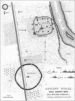
The Shriver Circle is a large, almost round shape made of earth. It has a ditch that goes all the way around it. This ancient site is located close to the Mound City Group and the Scioto River.
Most large Hopewell circles are nearly perfect. But the Shriver Circle is a bit unusual because it's more of an oblong (oval-like) shape. In the middle of the circle, there was once a low, cone-shaped mound. This mound was about 40 feet (12 meters) wide and 5 feet (1.5 meters) tall.
When the site was first studied in 1846, the earth walls were about 5 feet (1.5 meters) high and 25 feet (7.6 meters) wide. The ditch was about 20 feet (6 meters) wide and 4 feet (1.2 meters) deep. The walls and ditch had six openings, like gateways, around the edge.
An old map from before 1813 showed that the earth walls and mound were once much taller. They were probably at least 10 feet (3 meters) high. But by 1846, farming had already made them half their original height. This early map also showed nine gateways instead of six.
Sun Alignment at Shriver Circle
The central mound and one of the eastern gateways at Shriver Circle line up with the summer solstice sunrise. This means that on the longest day of the year, the sun rises right over a hill called Sugarloaf Mountain. This mountain is several miles away, across the Scioto River valley. This alignment shows how much the Hopewell people understood the movements of the sun.
Discoveries and Changes Over Time

The Shriver Circle Earthworks were first studied and dug into in 1846 by two archaeologists, Ephraim George Squier and Edwin Hamilton Davis. They named the site after Henry Shriver, who owned the land at that time.
Before Squier and Davis even started their work, parts of the site had already been changed. A road and a canal were built over the western side of the circle in the early 1830s.
When Squier and Davis dug into the central mound, they found many interesting things. They found artifacts made from copper and mica. They also found a lot of burned bones. The artifacts they found were more like those from the older Adena culture than from the nearby Mound City Group. Squier and Davis included the Shriver Circle in their important book, Ancient Monuments of the Mississippi Valley, which came out in 1848.
How the Site Changed
Over the years, much of the Shriver Circle site was damaged.
- Farming: In the 1800s and early 1900s, farming flattened many of the earthworks.
- Camp Sherman: During World War I, the United States Army built a large military training base called Camp Sherman right on top of the site. The circle was leveled to make a parade ground.
- Roads and Buildings: After the war, the camp was taken down. But then a road, Ohio State Route 104, was widened, causing more damage. In the 1960s, part of the site was covered when the Chillicothe Correctional Institution was built.
By the early 2000s, the earthworks were so flat that you couldn't see them just by looking at the ground. However, they could still be seen in old aerial photos. Archaeologists from the Hopewell Culture National Historical Park used special tools like magnetic surveys and LIDAR (which uses lasers to map the ground) to study the site in 2005. These tools helped them find the hidden shapes of the ancient earthworks.
 | Leon Lynch |
 | Milton P. Webster |
 | Ferdinand Smith |


