
Siege of Dunlap's Station facts for kids
Quick facts for kids Siege of Dunlap's Station |
|||||||
|---|---|---|---|---|---|---|---|
| Part of the Northwest Indian War | |||||||
 The Ohio Country with battles and massacres between 1775 and 1794 |
|||||||
|
|||||||
| Belligerents | |||||||
| Native Confederacy | |||||||
| Commanders and leaders | |||||||
| Blue Jacket Simon Girty |
Jacob Kingsbury Josiah Harmar |
||||||
| Strength | |||||||
| ~300–500 | ~30 | ||||||
| Casualties and losses | |||||||
| ~12–15 killed | 2 killed | ||||||
The siege of Dunlap's Station was a battle that happened on January 10–11, 1791. It was part of the Northwest Indian War. This conflict was between a group of Native American tribes, called the Western Confederacy, and European-American settlers. The battle took place in what is now southwestern Ohio.
This attack by the Native American forces was one of the few times they were not successful during this period. It happened soon after the Harmar Campaign, where the U.S. Army had faced a big defeat. A few months after the siege, the United States Army suffered another major loss to the Native Americans in what is known as St. Clair's Defeat.
Contents
Why the Battle Happened

For a very long time, Native peoples of the northeastern woodlands worked hard to survive and thrive on the North American continent. However, by the late 1600s, many Native American groups in the eastern areas had been forced out by the Iroquois and their allies.
Later, European-American settlers began moving into the Ohio Country. They had bought or been given land titles there. This led to many disagreements and fights with the Native American tribes who already lived in the area.
The Northwest Indian War started after the American Revolutionary War. People living in frontier areas north of the Ohio River were often attacked by Native American groups.
Dunlap's Station: A Frontier Outpost

Dunlap's Station was also known as Fort Colerain. It was built in early 1790 on the east bank of the Great Miami River. This area was part of what was also called Little Turtle's War. The station had three main purposes:
- It was a base for Americans to expand into Native American lands.
- It supported land sales by a company from New Jersey.
- It was a place for American farmers to settle and grow crops.
The Northwest Territory was created in 1787. Inside this territory, Judge Symmes started the Miami Company. This company advertised that land was available for sale. They hired an Irish surveyor named John Dunlap, who led a group of men, women, and children to the area.
The station was built near ancient earthworks and sacred mounds from the Adena culture. This location was good for farming because it was on fertile land.
The settlers cleared the land, built the station, and grew crops during their first summer. They built blockhouses to protect themselves from Native attacks, as this was still mainly Shawnee land. The settlers asked Fort Washington for soldiers to help protect them.
A small group of U.S. troops, led by Lieutenant Jacob Kingsbury, was sent to the fort. This group included a corporal and eleven other soldiers. Settlers' cabins were also part of the station.
Three blockhouses were built for the soldiers. There was also a shelter for a hand mill. The ten settlers' cabins faced each other. The settlers started clearing trees and brush to create a clear area for shooting, but they did not finish in time. The roofs of the buildings were also a problem because their lower edges were on the outside, which allowed dogs to get in. This was fixed, but there were still small gaps between some of the logs. The entire station was surrounded by an 8-foot-high fence made of log pickets, covering about one acre of land.

The First Attack
Native American leaders believed that the American soldiers and settlers were not well-trained. In late 1790, the chiefs of the allied tribes met with British agents. They asked for help to attack Dunlap's Station and another place called Baker's Station at the same time. Simon Girty, a "white Indian" (a white man who lived with and fought alongside Native Americans), was chosen to lead these attacks.
The fighting actually began on January 8, 1791, two days before the main siege. A group of surveyors, mostly civilians and soldiers not from Dunlap's Station, were exploring nearby land. They were surprised and attacked by Native American scouts.
These scouts were from several tribes: the Shawnee, Myaami (Miami-Illinois), Lenape (Delawares), Wyandots (Hurons), Niswi-mishkodewin (Potawatomi), Odawa (Ottawas), and Ojibwe (Chippewas). One man, Mr. Cunningham, was killed. Another, Abner Hunt, was captured. Captain John Sloan was wounded, and John S. Wallace helped him get back to the station.
The settlers and soldiers, led by Lieutenant Jacob Kingsbury, gathered in the blockhouses to get ready for an attack. The women even melted down spoons to make bullets. It rained, froze, and snowed about four to five inches deep that night. This weather made it hard for the attackers to use flaming arrows and torches.
The Siege Begins
On January 10, the Native American warriors came close to the station. They shouted that they were led by Simon Girty and demanded that the fort surrender. They used their captive, Abner Hunt, to translate. This talk lasted about an hour on the east side of the fort. While they were talking, shooting started on the opposite side, near the river. The shooting continued for two more hours, but the fort did not surrender. The attackers then pulled back until the evening, likely using the time to butcher cattle they had found.
Abner Hunt, the captive, was killed. There are different stories about how he died. Some reports said the Girty brothers were there and caused his death. However, an 1843 report suggests that Blue Jacket led this attack, and Girty was at Baker's Station at the time.
Lieutenant Kingsbury's detailed report to Harmar on January 12 simply called Hunt's death a "murder." Wallace, who had escaped earlier, went to get help. Reinforcements quickly came to assist the station. Fighting started again at dawn on January 11. However, the Native Americans did not have large siege weapons to break down the fort's defenses. They left around 8:00 A.M., just before a relief force from Fort Washington arrived around 10:00 A.M.
After the Battle
On January 14, Lieutenant Kingsbury was praised by Harmar for his actions. Just two weeks later, newspapers began to add more dramatic details to the story:
...The lieutenant answered, that if they were three hundred devils, he would not surrender; and immediately fired on the Indians, twelve of whom were killed. The remainder, after having quartered Mr. Hunt, in the view of the fort, made a rapid retreat: none of the garrison were either killed or wounded.
In late 1791 and early 1792, important figures like Thomas Jefferson and George Washington became involved after hearing about these events. Plans were made for a stronger fort the next year, possibly on the west bank of the Big Miami River, but it seems this fort was never built. George Washington did not officially approve the Symmes Purchase until 1794, and many other legal problems affected these land deals.
In 1881, a historian named Ford called this "the fiercest and longest sustained Indian attack recorded in the annals of Hamilton county." Dunlap's Station was later abandoned twice because it was too easy to attack. The area had seen many military movements. The station was very important for the survival of settlers in what became Hamilton, Butler, and Warren Counties. Settlers could only truly occupy the area after the defeat of Tecumseh's Confederation.

Images for kids
-
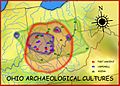
Map of ancient cultures in Ohio
-
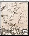
Detail from a 1796 map showing the Ohio River area
-
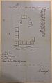
Shaumburgh's Plan of Dunlap's Station
-
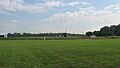
Site of Fort Dunlap today
Fiction
- The siege is mentioned in Indian-Artifact Magazine, vol. 14-3, pg 5, as part of a story about Tecumseh.
- It is also mentioned in Allan W. Eckert's book, The Life of Tecumseh (1992), on page 407.
