Sierra Baguales facts for kids
Quick facts for kids Sierra Baguales |
|
|---|---|

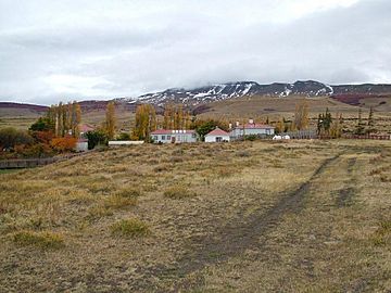
View to north of Cerro Guido and Estancia Cerro Guido
|
|
| Highest point | |
| Peak | Cerro Ciudadela |
| Elevation | 2,084 m (6,837 ft) |
| Dimensions | |
| Length | 60 km (37 mi) east-west |
| Geography | |
| Country | |
| State/Province | Santa Cruz Province Magallanes |
| Range coordinates | 50°44′S 72°24′W / 50.733°S 72.400°W |
| Parent range | Andes |
| Geology | |
| Age of rock | Late Eocene-Early Miocene |
| Type of rock | sedimentary rock igneous sills |
Sierra Baguales (also known as Sierra de los Baguales) is a cool mountain range found in the very southern part of the Andes mountains. It's like a long chain of mountains, about 60 kilometers (37 miles) long, stretching from east to west. This range is a bit separate from the main Andes mountains, which are further west. You can find Sierra Baguales right on the border between two countries: Chile and Argentina. It's close to towns like Puerto Natales and Río Turbio.
What Makes Sierra Baguales Special?
This mountain range has many bowl-shaped hollows called cirques. These cirques were carved out by ancient glaciers. Many of them formed during the Pleistocene Epoch, which was a long time ago. These glaciers were separate from the bigger ice sheets that were further west.
The rocks in Sierra Baguales are part of something called the Magallanes Basin. These rocks are super interesting because they hold fossils! Scientists have found fossils of plants, mammals, and even sea creatures that lived long ago.
Layers of Rock and Time
Scientists study the different layers of rock to understand the history of Sierra Baguales. Here are some of the main rock layers, from the newest at the top to the oldest at the bottom:
- Santa Cruz Formation: These are sedimentary rocks that formed on land. They contain many fossils of animals with backbones, like ancient mammals.
- Estancia 25 de Mayo Formation: This layer also has sedimentary rocks with fossils. They formed in the early Miocene epoch, and the sediments were laid down in a marine (ocean) environment.
- La Cumbre Formation: This is a layer of olivine-rich gabbro rock. It's an igneous sill, which means it formed when hot, melted rock pushed its way between other rock layers and cooled.
- Río Leona Formation: This layer contains fossils from non-marine environments. Some of these fossils include ancient Nothofagus trees, which are a type of beech tree.
- Bandurrías Formation: Another layer of olivine-rich gabbro sill, similar to the La Cumbre Formation.
- Loreto Formation: These sedimentary rocks are from the Late Eocene to Early Miocene periods. They are famous for containing fossilized shark teeth!
People have lived around Sierra Baguales for a very long time. On the eastern slopes, scientists have found ancient stone tools and other objects. Humans started living in the eastern foothills at least 4,500 years ago.
See also
 In Spanish: Sierra Baguales para niños
 | Janet Taylor Pickett |
 | Synthia Saint James |
 | Howardena Pindell |
 | Faith Ringgold |


