Signal Mountain (Wyoming) facts for kids
Quick facts for kids Signal Mountain |
|
|---|---|

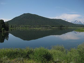
Signal Mountain reflected in the Snake River
|
|
| Highest point | |
| Elevation | 7,720 ft (2,350 m) |
| Prominence | 890 ft (270 m) |
| Geography | |
| Location | Grand Teton National Park, Teton County, Wyoming, U.S. |
| Topo map | USGS Moran (WY) |
| Climbing | |
| Easiest route | Hike |
Signal Mountain is a special mountain in Grand Teton National Park in Wyoming, USA. It stands alone, reaching about 7,720 feet (2,353 meters) above sea level. Because it's by itself, you can see amazing views from its top. You can look out over the Teton Range, the northern Jackson Hole area, and the Snake River.
Contents
How Signal Mountain Was Formed
Signal Mountain formed in a different way than the nearby Teton Mountains. It was created by volcanic ash. This ash came from eruptions of the Yellowstone hotspot a long time ago.
Glaciers Shaped the Mountain
Later, a huge sheet of ice, called a glacier, helped shape the mountain. This glacier moved south from the Yellowstone icecap. As it melted and moved back, it left behind rocks and dirt, forming part of Signal Mountain. This same glacier also helped create the nearby Jackson Lake.
Exploring Signal Mountain
There are two main ways to explore Signal Mountain: by car or by hiking. Both offer great chances to see the park's beauty.
Driving to the Top
A five-mile (8 km) long road goes up Signal Mountain. This road leads to a special viewing area near the main summit. It's a popular spot for people to drive up and enjoy the scenery.
Hiking the Signal Mountain Trail
The Signal Mountain Trail is a hiking path that starts at Signal Mountain Lodge. It goes all the way to the summit, covering about 6.8 miles (10.9 km).
- Trail Split: About halfway up, the trail splits for 1.5 miles (2.4 km). Hikers can choose to walk along the lower part of the ridge. Or they can go south of the ridge, past several small ponds.
- Rejoining and Steep Climb: The trails then come back together. The path gets steeper over the last mile to reach the Jackson Lake Overlook. This is a secondary summit of the mountain.
- Elevation Gain: The trail climbs about 800 feet (244 meters) from the lodge to the overlook. If you take the ridge trail, you'll have a bit more up and down walking.
Rules for Hikers
The Signal Mountain Trail is only for hiking. You cannot ride mountain bikes or horses on this trail. This rule helps protect the park and makes sure everyone has a safe experience.
Biking on the Road
The road up Signal Mountain is a favorite spot for bikers. It's a challenging climb to the top. But after turning around, bikers enjoy a continuous downhill ride for about 3.5 miles (5.6 km).
 | Jewel Prestage |
 | Ella Baker |
 | Fannie Lou Hamer |


