Slievecallan facts for kids
Quick facts for kids Slievecallan |
|
|---|---|
| Sliabh Calláin | |

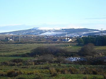
Slievecallan in January 2010.
|
|
| Highest point | |
| Elevation | 391 m (1,283 ft) |
| Prominence | 365 m (1,198 ft) |
| Listing | Marilyn |
| Geography | |
| OSI/OSNI grid | R144773 |
Slievecallan (also called Slieve Callan), or Sliabh Calláin in Irish, is a mountain in County Clare, Ireland. It is sometimes called 'Mount Callan'. The mountain is about 391 meters (1,283 feet) tall. This makes it the third highest mountain in County Clare.
On its south side, you can find a small lake and two ancient stone tombs. For a long time, people gathered on the mountain for special events. In 2017, a wind farm was built on Slievecallan. This project included new roads and power stations. Some local people and a group called An Taisce (which works to protect Ireland's heritage) were against the wind farm.
Contents
Ancient History and Discoveries
On the south side of Slievecallan, there are two very old stone tombs. These are called megalithic tombs. One is on the mountain itself, and the other is closer to the Ennis Road. Old Irish stories say it's bad luck to harm these ancient tombs.
The Ogham Stone Mystery
In the late 1700s, a special stone was found in the same area. It had ancient Irish writing on it called ogham. This was the first ogham stone ever translated and shared with the public. The writing on the stone said it marked the grave of a hero named Conán. He was part of the fianna, a group of warriors from Irish mythology.
Some people, like Charles Vallancey, believed a poem from an old story, Cath Gabhra, said Conán died at Slievecallan. They thought he died during a ceremony to worship the sun. Michael Comyn wrote that people would gather at a place called Buaile na Gréine (which means "summer pasture of the Sun"). Here, they would offer animals to the Sun at a stone altar. There is even a small lake on the mountain called Lough Boolynagreana.
However, we now know that the ogham stone was likely carved not long before it was found. Also, the poem about Conán in Cath Gabhra isn't in the original story. Even so, this stone made people very interested in old Irish history and the study of ogham writing.
Lughnasa Celebrations
Until recently, people would gather on Slievecallan every August. They celebrated a festival called Lughnasa. This was an ancient Irish festival marking the end of summer and the harvest.
Where is Slievecallan?
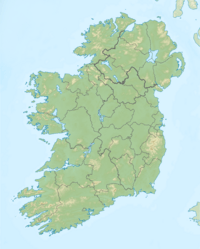
Slievecallan is located in the western part of County Clare. It sits in the middle of a triangle formed by three villages: Milltown Malbay, Inagh, and Connolly.
Two main roads pass near the mountain. The R474 road, which connects Ennis and Milltown Malbay, runs along the south side. The R460 road, connecting Gort and Milltown Malbay, passes on the north side.
Mountain Environment
Slievecallan has a very wet climate because it is close to the ocean. It gets about 2,000 millimeters (about 79 inches) of rain each year. It also has strong winds. This is because the ocean is only 8 kilometers (5 miles) away, and the mountain stands out in the landscape.
The soil on Slievecallan is made up of peat (decayed plant matter) and gley soils. These soils are on top of layers of shale, sandstone, and mudstone. The soil does not have many nutrients.
Plants and Trees
If humans had not changed the area, Slievecallan would mostly be covered in forests. These forests would have ash trees in areas with alkaline soil. In more acidic areas, you would find hazel and oak trees.
Today (as of 2014), most of the land around Slievecallan is heathland (open land with small shrubs), pastures for animals, and planted forests. Many of these planted forests are made up of Sitka spruce trees, which are not native to Ireland.
 | Georgia Louise Harris Brown |
 | Julian Abele |
 | Norma Merrick Sklarek |
 | William Sidney Pittman |


