
Smith River (California) facts for kids
Quick facts for kids Smith River (California) |
|
|---|---|

The mouth of the Smith River as it enters the Pacific Ocean
|
|

Map of the Smith River watershed
|
|
| Country | United States |
| State | California |
| Physical characteristics | |
| Main source | Confluence of North and Middle Forks Gasquet, Klamath Mountains, Six Rivers National Forest, Del Norte County 315 ft (96 m) 41°50′52″N 123°58′08″W / 41.84778°N 123.96889°W |
| River mouth | Pacific Ocean near community of Smith River, Del Norte County 0 ft (0 m) 41°56′10″N 124°12′12″W / 41.93611°N 124.20333°W |
| Length | 25.1 mi (40.4 km) |
| Basin features | |
| Basin size | 719 sq mi (1,860 km2) |
| Tributaries |
|
| Type: | Wild, Scenic, Recreational |
| Designated: | January 19, 1981 |
The Smith River is a beautiful river in Del Norte County, located in the far northwestern part of California. It flows from the Klamath Mountains all the way to the Pacific Ocean. This river is special because it's about 25.1 miles (40.4 km) long and stays entirely within Del Norte County. It also flows through amazing places like the Rogue River – Siskiyou National Forest, Six Rivers National Forest, and Jedediah Smith Redwoods State Park.
Contents
How the Smith River Flows
The Smith River begins when two of its main branches, the Middle Fork and the North Fork, join together near a town called Gasquet.
- The Middle Fork is about 27.8 miles long. It starts in Del Norte County and flows west.
- The North Fork Smith River is about 28.1 miles long. It begins in Oregon, on the side of Chetco Peak.
Another important branch, the South Fork Smith River, joins the main river near the community of Hiouchi. This fork is about 43.3 miles (69.7 km) long. It starts in the eastern part of the Smith River National Recreation Area.
After the South Fork joins, the Smith River generally flows northwest. It finally reaches the Pacific Ocean near the community of Smith River. This spot is about 10 miles (16 km) north of Crescent City. The area where the river meets the ocean, called the Smith River estuary, is a protected place.
The River's Water Area
The Smith River's watershed is a large area of land, covering about 719 square miles (1,862 km²). A watershed is like a giant bowl where all the rain and snowmelt collect and flow into one river. This watershed is in a rugged area of the western Klamath Mountains, just south of the Oregon border.
The Smith River is unique because it's the largest river system in California that flows completely freely. This means it doesn't have any dams along its entire path! The amount of water flowing in the river changes a lot throughout the year. On average, about 3,746 cubic feet (106.1 m³) of water flows per second. The most water usually flows in January, and the least in September. The highest flow ever recorded was a massive 228,000 cubic feet (6,456 m³) per second during a big flood in December 1964.
The river was named after an explorer named Jedediah Smith.
Protecting the Smith River
Because the Smith River flows freely without any dams, it's very important to people who work to protect nature. It's considered one of the best examples in the National Wild and Scenic Rivers System program. This program helps protect special rivers so they can stay wild and beautiful for everyone to enjoy.
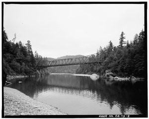
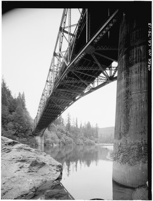
Bridges Over the River
The old Smith River Bridge, also known as the Hiouchi Bridge, was built in 1929. It was a special type of cantilever truss bridge that carried California State Highway 197 across the river. This kind of bridge was not very common in California.
The parts for the bridge were made far away in Virginia. They were then shipped by boat through the Panama Canal to San Francisco, and then to Crescent City. The middle part of the bridge was a "Parker truss" design.
This bridge was one of the first of its kind designed by California engineers. While popular for a short time, only a few were built in the state. The design was inspired by an earlier bridge called the Carquinez Bridge.
By 1987, people started looking into replacing the Smith River Bridge. Highway 197 is an important road that connects Highway 101 on the coast to Interstate Highway 5 inland in Oregon. The old bridge was getting old and worn out. Many heavy trucks used the road, which damaged the bridge over the years. There was concern that it might not be safe anymore.
Because the bridge was considered historically important, it had to be carefully recorded before it was taken down in 1989. This recording was done following standards set by the Historic American Engineering Record−HAER.
