
Somme (river) facts for kids
Quick facts for kids Somme |
|
|---|---|

The Somme
|
|

Course in Northern France
|
|
| Country | France |
| Region | Picardy |
| Physical characteristics | |
| Main source | Fonsommes 85 m (279 ft) 49°54′23″N 03°24′11″E / 49.90639°N 3.40306°E |
| River mouth | Saint-Valery-sur-Somme English Channel 50°11′10″N 01°38′35″E / 50.18611°N 1.64306°E |
| Length | 245 km (152 mi) |
| Basin features | |
| Basin size | 6,550 km2 (2,530 sq mi) |
The Somme is a river located in Picardy, a region in northern France. It flows for about 245 kilometers (152 miles). The river starts in the high ground near Fonsommes and ends in the Bay of the Somme, which opens into the English Channel.
The Somme River flows through a special dip in the ground, like a long, shallow valley. This makes the river flow quite smoothly and gently. Along its path, you can see several flat areas that were formed by the river over time.
What's in a Name?
In ancient times, the Somme River was called Samara. This name likely meant 'the summery river' or 'the quiet river'. It comes from an old Celtic word that meant 'summer'.
The city of Amiens was once known as Samarobriva, which means 'bridge on the Samara' in the old Gaulish language. This city was important to an ancient tribe called the Ambiani. Today, the French area called the Somme department is named after this famous river.
A River of History

The Somme River has played a big part in many important battles and historical events.
- In 1066, the ships of William the Conqueror gathered in the Bay of the Somme before they sailed to England.
- In 1346, during a war, the army of Edward III of England crossed the river at a place called the Battle of Blanchetaque. This happened before the famous Battle of Crécy.
- Later, in 1415, crossing the Somme was also a key part of the plan that led to the Battle of Agincourt.
- In 1636, during the Thirty Years War, a Spanish army crossed the Somme and defeated a French army. This event even threatened the city of Paris.
The Battle of the Somme
The most famous event linked to the river is the Battle of the Somme during World War I. This terrible battle lasted from July to November 1916. It caused more than a million people to be killed, wounded, or go missing.
A soldier named Private A. S. Bullock wrote about seeing the river in 1918. He described it as "a muddy, sluggish and somewhat narrow stream." He noted that this river gave its name to "one of the most awful battles in history."
Later in 1918, major battles were fought around the Somme valley. These battles, like the one at Villers Bretonneux, helped stop a big German attack and marked the beginning of the end of the war.
Towns Along the Somme
The Somme River flows through several important towns and areas in France:
- In the Aisne area: Saint-Quentin
- In the Somme area: Ham, Péronne, Corbie, Amiens, Abbeville, Saint-Valery-sur-Somme, Le Crotoy

How the River Works
The Somme River flows very steadily because it is fed by water from underground. The valley has steep sides, but its bottom is flat and often has wet, marshy areas called fens and pools.
Long ago, during very cold periods, the river carved its path deeper than the current water level. Now, the valley bottom is filled with water, which has created these marshy fens.
In 2001, the Somme valley experienced very high floods. These floods happened because the underground water levels in the surrounding land rose a lot.
Boating and Canals

The Canal de la Somme was built to help boats travel along the river. Construction started in 1770 and finished in 1843. This canal is about 156 kilometers (97 miles) long. It begins at St.Simon and connects to the Bay of the Somme.
Part of the canal runs right next to the river, and other parts use the river itself for navigation. Near Abbeville, the river is guided through an old, muddy area of its mouth, leading to Saint-Valery-sur-Somme and then into the English Channel.
Other important canals connect to the Somme:
- The St Quentin Canal links the Somme to northern France and Belgium. It also connects southward to the Oise River. This canal is famous for a battle fought there in 1918.
- The Canal du Nord also connects the Somme to the Oise River, near Noyon, which then leads to Paris.
Images for kids
-
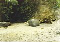
The source of the Somme, at Fonsommes
-
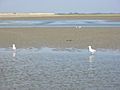
The estuary is now much smaller than it once was but still extensive.


See also
 In Spanish: Río Somme para niños
