South Branch Kishwaukee River facts for kids
Quick facts for kids South Branch Kishwaukee River |
|
|---|---|

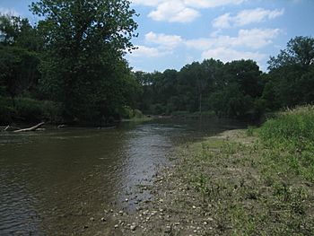
The South Branch Kishwaukee River flowing through Kishwaukee River State Fish and Wildlife Area, summer 2007
|
|
| Physical characteristics | |
| Main source | Shabbona Township, DeKalb County, Illinois 900 ft (270 m) 41°46′24″N 88°54′06″W / 41.7733333°N 88.9016667°W |
| River mouth | Confluence with the Kishwaukee River near Rockford, Illinois 709 ft (216 m) 42°12′00″N 88°59′01″W / 42.2°N 88.9836111°W |
| Length | 64 mi (103 km) |
| Basin features | |
| Progression | South Branch Kishwaukee River → Kishwaukee → Rock → Mississippi → Gulf of Mexico |
| GNIS ID | 422087 |
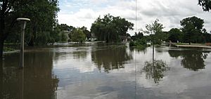
The South Branch Kishwaukee River is a 63.6-mile-long (102.4 km) river in northern Illinois. It's a major part of the Kishwaukee River system. This river flows through DeKalb County. In 2007, heavy rains caused the river to flood parts of DeKalb County and Sycamore, Illinois.
There's also another stream with the same name, South Branch Kishwaukee River. This second stream flows through Kane County and McHenry County. It joins the main Kishwaukee River east of Marengo.
Where the River Flows: Its Journey
The South Branch Kishwaukee River is a big tributary (a stream that flows into a larger stream or river) of the Kishwaukee River. It starts near Shabbona, Illinois, on a landform called the Cropsey Moraine. The river first flows northeast. When it reaches Genoa, it turns and starts flowing west-northwest.
The South Branch is the largest tributary of the Kishwaukee River. This means it drains the most land area, about 441 square miles (1,142 km2). The South Branch joins the main Kishwaukee River about 10.6 miles (17.1 km) before the Kishwaukee River meets the Rock River.
About the River: What It's Like
Part of the South Branch's river bed (the bottom of the river) used to be an ancient lake. The river winds its way over moraines, which are hills made of rocks and dirt left behind by glaciers. The riverbed itself is made of rocks, sand, and gravel. North of Sycamore, people have even mined gravel from the river.
The South Branch is usually about 55 feet (17 m) wide. It naturally has the lowest flow rate (how much water moves through it) compared to other streams in the Kishwaukee River area. However, it also receives the most water from treated wastewater that comes from the city of DeKalb.
In 1996, the Illinois Environmental Protection Agency checked about 62 miles (100 km) of the South Branch. They found that 30 miles (48 km) of the river were in "fair" condition, and 32 miles (51 km) were in "good" condition. The main reasons for the lower quality parts were too many nutrients and low oxygen levels. These issues came from farming and treated wastewater from towns.
River Flooding: When the Water Rises
When the South Branch Kishwaukee River flows through DeKalb County, the flood stage (the level at which the river starts to cause flooding) is 10.0 feet (3 m). Since 1926, the river has gone above this flood stage nine times. The biggest flood ever happened on July 2, 1983, when the river reached 15.8 feet (4.8 m).
Flash flooding can happen in low-lying areas near the river, especially in mid to late summer. This type of flooding happens very quickly. Floods in 1973, 1974, 1993, 1996, and 2007 were so bad that they were declared federal disaster areas. This means the government provided special help to the people affected.
On August 23 and 24, 2007, about 4.85 inches (123 mm) of rain fell in DeKalb. This caused the South Branch Kishwaukee River to rise to its second-highest level ever recorded, only lower than the 1983 flood. Many roads and bridges had to close. The cities of DeKalb and Sycamore declared local emergencies.
President George W. Bush declared several counties in northern Illinois, including DeKalb, Grundy, Kane, LaSalle, Lake, and Will, as "major disaster" areas. This allowed federal money to help flood victims. In DeKalb and Sycamore, about 600 people had to leave their homes. The DeKalb campus of Northern Illinois University also closed because of the flood.
 | Selma Burke |
 | Pauline Powell Burns |
 | Frederick J. Brown |
 | Robert Blackburn |


