South Patrick Shores, Florida facts for kids
Quick facts for kids
South Patrick Shores, Florida
|
|
|---|---|

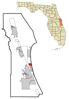
Location in Brevard County and the state of Florida
|
|
| Country | |
| State | |
| County | Brevard |
| Area | |
| • Total | 3.21 sq mi (8.32 km2) |
| • Land | 1.51 sq mi (3.92 km2) |
| • Water | 1.70 sq mi (4.40 km2) |
| Elevation | 13 ft (4 m) |
| Population
(2020)
|
|
| • Total | 6,496 |
| • Density | 4,293.46/sq mi (1,657.73/km2) |
| Time zone | UTC-5 (Eastern (EST)) |
| • Summer (DST) | UTC-4 (EDT) |
| ZIP code |
32937
|
| Area code(s) | 321 |
| FIPS code | 12-67725 |
| GNIS feature ID | 1867209 |
South Patrick Shores is a special kind of community in Brevard County, Florida, United States. It's called a census-designated place (CDP). This means it's an area that looks like a town but doesn't have its own local government. The government counts the people here for official records.
In 2020, about 6,496 people lived in South Patrick Shores. This was more than the 5,875 people who lived there in 2010. It's part of a larger area that includes the cities of Palm Bay, Melbourne, and Titusville, Florida.
Contents
Where is South Patrick Shores?
South Patrick Shores is located in Florida, right by the coast. Its exact spot is 28°12′9″N 80°36′14″W / 28.20250°N 80.60389°W.
The total area of South Patrick Shores is about 3.21 square miles (8.32 square kilometers). A big part of this area is water! About 1.51 square miles (3.92 square kilometers) is land, and 1.70 square miles (4.40 square kilometers) is water. This means almost half of the area is covered by water.
What's Around South Patrick Shores?
South Patrick Shores is surrounded by interesting places:
- To the east, you'll find the amazing Atlantic Ocean.
- To the north is Patrick Space Force Base, a place important for space activities.
- To the south is the town of Satellite Beach.
- To the west are the Banana River, Merritt Island, and a small community called Tropic.
Who Lives Here?
We can learn about the people living in South Patrick Shores from official counts called a census. Here's how the population has changed over the years:
| Historical population | |||
|---|---|---|---|
| Census | Pop. | %± | |
| 1990 | 10,249 | — | |
| 2000 | 8,913 | −13.0% | |
| 2010 | 5,875 | −34.1% | |
| 2020 | 6,496 | 10.6% | |
| U.S. Decennial Census | |||
In 2000, there were 8,913 people living in South Patrick Shores. There were also 3,563 homes, which we call households. Many of these were families, including married couples.
The people living here come from many different backgrounds. Most residents were White, but there were also people who identified as African American, Native American, Asian, Pacific Islander, or from two or more races. About 5% of the population was of Hispanic or Latino background.
The average age of people in South Patrick Shores in 2000 was 40 years old. About 24% of the people were under 18, and about 19% were 65 or older.
The average yearly income for a household in 2000 was about $48,197. For families, it was around $53,231. A small number of people, about 4.6%, lived below the poverty line.
Getting Around Town
South Patrick Shores has some important roads that help people travel.
One of the most famous roads is SR A1A, also known as Miramar Avenue. Travelocity.com even called it the "Best Driving Route" in Florida because it runs so close to the ocean! Imagine driving with ocean views!
Another main road that runs next to the Banana River is SR 513, or South Patrick Drive. These roads are maintained by the Florida Department of Transportation.
Images for kids
See also
 In Spanish: South Patrick Shores para niños
 | Toni Morrison |
 | Barack Obama |
 | Martin Luther King Jr. |
 | Ralph Bunche |


