South Riding, Virginia facts for kids
Quick facts for kids
South Riding, Virginia
|
|
|---|---|

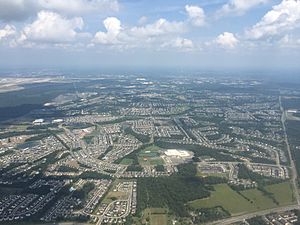
View of South Riding, with Freedom High School visible in the lower center
|
|
| Country | |
| State | |
| County | |
| Founded | January 1995 |
| Named for | South Yorkshire |
| Government | |
| • Type | Board of Directors |
| Area | |
| • Total | 6.92 sq mi (17.92 km2) |
| • Land | 6.85 sq mi (17.73 km2) |
| • Water | 0.07 sq mi (0.19 km2) |
| Elevation | 295 ft (90 m) |
| Population
(2010)
|
|
| • Total | 33,877 |
| • Estimate
(2020)
|
33,877 |
| • Density | 4,896.2/sq mi (1,890.45/km2) |
| Time zone | UTC−5 (Eastern (EST)) |
| • Summer (DST) | UTC−4 (EDT) |
| ZIP code |
20152 (Chantilly)
|
| Area code(s) | 703 |
| FIPS code | 51-74100 |
| GNIS feature ID | 2584921 |
South Riding is a special kind of town in Loudoun County, Virginia, USA. It's a planned community, which means it was carefully designed before people moved in. A group called the South Riding homeowner association started in January 1995. They help manage the community and provide services to everyone living there.
It's close to big roads like U.S. Route 50 and Virginia State Route 28. These roads make it easy to get to nearby tech hubs like Dulles and Reston. They also connect South Riding to other major work areas in Northern Virginia and Washington, D.C.. In 2020, about 33,877 people lived in South Riding.
Contents
History of South Riding
How South Riding Started
In January 1995, the land owners created South Riding Proprietary. This was a not-for-profit group to provide services to the future residents. In 2009, this group was given a special status by the Internal Revenue Service. South Riding Proprietary still owns and manages the community today.
Fun Things to Do in South Riding
Parks, Pools, and Golf
South Riding has many green spaces and about 6 miles of trails for walking or biking. The Dulles South Recreation & Community Center manages parks and activities. This center has a climbing wall, a big swimming pool, and a fun leisure pool. There's also a senior center and rooms you can rent for events.
South Riding is home to the South Riding Golf Club. It was designed by Dan Maples and opened in 1997. The club has won awards, like being named one of the "Top 100 Courses in the Mid-Atlantic." Golf Digest also called it the "Best New Course" in 1998.
The town has several outdoor pools, including South Riding Center Pool and Meadows Pool. There's also the Town Hall Pool and the Hyland Hills Swimming Pool and Splash Park. Plus, you can use the indoor pools at the Dulles South Recreation & Community Center.
Getting Around South Riding
South Riding is less than a mile south of U.S. Route 50. This road connects the town to Chantilly and Virginia State Route 28 to the east. Several other main roads cross through South Riding. These include Tall Cedars Parkway and Poland Road in the center. Loudoun County Parkway is slightly to the west.
Gum Spring Road forms the town's western border. The Fairfax County line is the town's eastern border. South Riding has a bus station in the Town Center. It's the starting point for the Route 88 bus. This bus connects South Riding to other towns like Stone Ridge. Residents can also easily reach Dulles Airport, which is only 10 miles away, for international flights.
South Riding's Location and Climate
Where is South Riding?
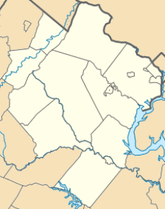
South Riding is located in the southeastern part of Loudoun County. Nearby towns include Arcola and Dulles to the north. Stone Ridge is to the west, and Conklin is to the south. Chantilly in Fairfax County is to the east.
The total area of South Riding is about 17.9 square kilometers (6.9 square miles). A small part of this, about 0.2 square kilometers (0.1 square miles), is water. The community gets its water from Elklick Run. This stream flows into Cub Run, which is part of the Bull Run watershed. Eventually, this water flows into the Potomac River.
Weather in South Riding
South Riding has a humid subtropical climate. This means it has hot, humid summers. Winters are usually mild to cool.
| Month | Jan | Feb | Mar | Apr | May | Jun | Jul | Aug | Sep | Oct | Nov | Dec | Year |
|---|---|---|---|---|---|---|---|---|---|---|---|---|---|
| Record high °F (°C) | 75 (23) | 79 (26) | 89 (31) | 93 (33) | 97 (36) | 102 (38) | 105 (40) | 104 (40) | 99 (37) | 94 (34) | 84 (28) | 79 (26) | 105 (40) |
| Average high °F (°C) | 42.5 (5.8) | 46.4 (8) | 55.5 (13) | 66.7 (19.2) | 75.1 (23.9) | 83.8 (28.7) | 87.9 (31) | 86.6 (30.3) | 79.4 (26.3) | 68.2 (20.1) | 57.5 (14.1) | 46 (7.7) | 66.3 (19) |
| Average low °F (°C) | 23.9 (-4.5) | 26 (-3.3) | 32.9 (0.5) | 42.1 (5.6) | 51.2 (10.6) | 61 (16.1) | 65.5 (18.6) | 64.2 (17.8) | 56.3 (13.5) | 43.8 (6.5) | 35.3 (1.8) | 27.1 (-2.7) | 44.1 (6.7) |
| Record low °F (°C) | -18 (-27) | -14 (-25) | -1 (-18) | 17 (-8) | 28 (-2) | 36 (2) | 41 (5) | 38 (3) | 30 (-1) | 15 (-9) | 9 (-12) | -4 (-20) | -18 (-27) |
| Average precipitation inches (mm) | 2.7 (68) | 2.7 (68) | 3.4 (86) | 3.5 (88) | 4.6 (115) | 4 (101) | 3.7 (93) | 3.5 (88) | 3.9 (99) | 3.3 (83) | 3.4 (86) | 3 (76) | 41.5 (1054) |
| Average snowfall inches (cm) | 7.3 (18.5) | 7.6 (19.3) | 2.8 (7.1) | 0.3 (0.7) | 0 (0) | 0 (0) | 0 (0) | 0 (0) | 0 (0) | 0 (0) | 0.5 (1.2) | 3.5 (8.8) | 22 (55.8) |
| Average precipitation days | 10 | 9 | 11 | 11 | 12 | 11 | 11 | 9 | 9 | 8 | 9 | 10 | 119 |
| Average snowy days | 4 | 3 | 2 | 0 | 0 | 0 | 0 | 0 | 0 | 0 | 0 | 2 | 10 |
News and Media
South Riding gets its news from two national newspapers: The Washington Post and The Washington Times. There's also a local newspaper called the Loudoun Times-Mirror. The town is also covered by AOL's Patch service, specifically its Chantilly section.
Schools and Learning
Local Schools
South Riding is part of the Loudoun County Public Schools system. It also has private schools. The town has one high school, Freedom High School, which serves all students in the area. Middle schoolers attend either J. Michael Lunsford Middle School or Mercer Middle School.
Public Elementary Schools
- Hutchison Farm Elementary School
- Cardinal Ridge Elementary
- Little River Elementary School
- Pinebrook Elementary
- Liberty Elementary School
Day Care and After-School Programs
- Montessori School of South Riding
- Everbrook Academy of South Riding
- Minnieland Academy at South Riding
- Kiddie Academy of South Riding
- The Madame Curie School of Science & Technology
- ALOHA Mind Math of South Riding
- East Gate Montessori School
- The Goddard School of Chantilly
- Winwood Children's Center
- C2 Education of South Riding
- South Riding KinderCare
- Primrose School of South Riding
- Huntington Learning Center of South Riding
- South Riding Learning Center
Private High Schools
- St. Paul VI Catholic High School
Public Libraries
South Riding residents can use the Gum Spring Library. This library is a branch of the Loudoun County Public Library system and is located in Stone Ridge.
People of South Riding
Population and Diversity
In 2021, the average household income in South Riding was $170,456. The population of South Riding has grown over time. In 2010, the population was 24,256, and by 2020, it had increased to 33,877.
South Riding is a diverse community. Here's a look at the different groups of people living there:
| Race / Ethnicity | Pop 2010 | Pop 2020 | % 2010 | % 2020 |
|---|---|---|---|---|
| White alone (NH) | 13,019 | 13,555 | 53.67% | 40.01% |
| Black or African American alone (NH) | 1,506 | 2,409 | 6.21% | 7.11% |
| Native American or Alaska Native alone (NH) | 39 | 47 | 0.16% | 0.14% |
| Asian alone (NH) | 6,995 | 13,161 | 28.84% | 38.85% |
| Pacific Islander alone (NH) | 10 | 27 | 0.04% | 0.08% |
| Some Other Race alone (NH) | 44 | 149 | 0.18% | 0.44% |
| Mixed Race/Multi-Racial (NH) | 837 | 1,866 | 3.45% | 5.51% |
| Hispanic or Latino (any race) | 1,806 | 2,663 | 7.45% | 7.86% |
| Total | 24,256 | 33,877 | 100% | 100% |
| Historical population | |||
|---|---|---|---|
| Census | Pop. | %± | |
| 2010 | 22,982 | — | |
| 2018 (est.) | 31,071 | 35.2% | |
As of the 2022 census, the population breakdown was:
- White: 41.4%
- Black: 9.9%
- Asian: 35.3%
- Hispanic: 9.0%
Between 2010 and 2022, the White population decreased by over 30%. The Asian population increased by more than 20%. The Latino population decreased slightly by 0.9%. Looking at age groups, 6.0% of the population is under 5 years old. About 30.3% are under 18 years old. People aged 65 or older make up about 5.3% of the total. Females make up 49.0% of the total population.
The number of people living per square mile also increased. In 2010, there were 3,516.1 people per square mile. By 2020, this number grew to 4,949.2 people per square mile.
Famous People from South Riding
- Kevin Paredes (born 2003) – He is a professional soccer player. He plays for the United States national team and was an Olympian.
See also
 In Spanish: South Riding (Virginia) para niños
 | John T. Biggers |
 | Thomas Blackshear |
 | Mark Bradford |
 | Beverly Buchanan |


