
South Side Flats (Pittsburgh) facts for kids
|
||||||||||||||||||||||||||||||||||||||||||||||||||||


The South Side Flats is a lively neighborhood in Pittsburgh, Pennsylvania. It's part of Pittsburgh's South Side area, right next to the Monongahela River. This neighborhood is famous for having lots of old homes from the 1800s. People sometimes call it Pittsburgh's Georgetown because of these historic buildings.
The South Side Flats has many cool places like restaurants and shops. It also has lots of homes where people live. The main street is East Carson Street, which is well-known for its fun nightlife in Pittsburgh.
Contents
A Look Back: South Side Flats History
The South Side area was once made up of several smaller towns. These included Birmingham and East Birmingham, named after the industrial city of Birmingham in England. Ormsby was another town, and South Pittsburgh was near the Smithfield Street Bridge. There was also Monongahela, named for the nearby river. All these towns became part of Pittsburgh in 1872.
Early Beginnings and John Ormsby
In 1763, a large area of land on the South Side was given to Major John Ormsby. This was a thank you for his help in building Fort Pitt. By the 1770s, Ormsby had built a home on this land. He also started a ferry service to connect his home with the community in Pittsburgh.
How Birmingham Was Founded
In 1811, Ormsby's son-in-law, Dr. Nathaniel Bedford, planned a new town on the flat land. He named it Birmingham to honor his own hometown. Dr. Bedford was the first doctor in the area now known as Allegheny County.
He named the streets after Ormsby's children: Mary, Jane, Sarah, and Sidney. These names are still used for streets in the South Side today. Carson Street was named after a sea captain who was a friend of Dr. Bedford. It was once part of the Washington Pike, a main road to Washington, Pennsylvania.
Growth of Industry and Steel
Birmingham quickly became a big industrial area. This was because it was easy to move goods by river and train. First, it was a center for making glass. Then, it became known for iron and steel.
In 1850, Benjamin Franklin Jones invested in an iron works on the South Side. Later, he teamed up with a banker named James H. Laughlin. Their company, Jones and Laughlin Steel Company, became the biggest employer in the South Side. By 1910, it had over 15,000 workers! In 1950, the factory expanded, and some homes had to be moved.
Many workers who came to live here were immigrants from Eastern Europe. They brought their cultures and traditions, and you can still see many of their churches, clubs, and bars in the South Side today.
Changes and New Beginnings
When the steel industry started to decline, it hit the neighborhood hard. The J&L Plant had layoffs, and the Levinson Steel Company closed in 1981. This factory site was later turned into a shopping center.
In the early 1980s, some important buildings were damaged by fires. The Arcade Theater, which was the first theater outside of Downtown Pittsburgh to have sound and air conditioning, was also destroyed. A Rite Aid pharmacy is now on that spot.
But the South Side began to rebuild. In 1982, the Pittsburgh History and Landmarks Foundation helped start the South Side Local Development Company. In 1985, East Carson Street was chosen for a special program to help historic main streets. The community worked together to redevelop the old J&L site.
The J&L/LTV steel plant closed in 1986. There was a plan to save some of the old factory buildings, but it didn't work out because they were unsafe. However, the old J&L sign was saved for future use. The city bought the site in 1993 and later turned it into the Southside Works complex. This project brought many national stores to the eastern part of the neighborhood.
Where is South Side Flats?
The South Side Flats is located at 40°25′43.76″N 79°59′8.08″W and covers about 0.936 square miles (2.42 square kilometers).
The South Side Riverfront Park runs along most of the border with the Monongahela River. Many events happen here, like the yearly Pittsburgh Dragon Boat Festival. The Three Rivers Heritage Trail also goes through this park.
Neighboring Areas
To the west, the South Side Flats borders the Pittsburgh neighborhood of South Shore. To the south, it borders the South Side Slopes. As the Flats curve, they border Arlington to the west and a small part of Baldwin to the south.
The Flats are also connected to three Pittsburgh neighborhoods across the Monongahela River by bridges:
- The Birmingham Bridge connects the Flats with the Bluff to the west.
- The Hot Metal Bridge connects the Flats with South Oakland to the northeast and Hazelwood to the east.
People of South Side Flats
| Historical population | ||
|---|---|---|
| Year | Pop. | ±% |
| 1940 | 22,476 | — |
| 1950 | 17,942 | −20.2% |
| 1960 | 12,586 | −29.9% |
| 1970 | 9,260 | −26.4% |
| 1980 | 7,894 | −14.8% |
| 1990 | 6,177 | −21.8% |
| 2000 | 5,726 | −7.3% |
| 2010 | 6,597 | +15.2% |
| Source:
|
||
In 2000, about 5,726 people lived in the South Side Flats. Most residents (95.2%) were White, with smaller percentages of African American, Native American, Asian, and other racial groups. About 1.3% of the population was Hispanic or Latino.
By 2010, the population had grown to 6,597 people. The neighborhood became more diverse, and there were fewer residents over 65 years old compared to 2000. Most homes were occupied, and many were rented.
Fun Facts About South Side Flats
- The famous Kaufmanns Department Store started as a tailor shop on Carson Street in the South Side in 1871.
- The South Side had Pittsburgh's very first electric railway! It ran from 13th and Carson to Mount Oliver Borough.
- The base of the Knoxville Incline was at 12th Street. This incline, built in 1890, had a unique 18-degree curve and was the longest incline ever built in Pittsburgh.
Gallery
-
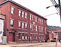
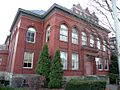
Bedford School, built in 1850, at 910 Bingham Street.
-
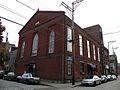
Former First Associate Reformed Presbyterian Church (now Gypsy Café), built 1854, at 20 South 14th Street.
-
City Theatre, built in 1859, at 1300 Bingham Street.
-
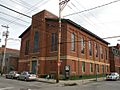
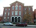
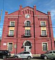
Birmingham Public School, built circa 1870, at 118–128 South 15th Street.
-
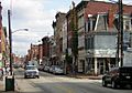
East Carson Street Historic District in the South Side Flats neighborhood of Pittsburgh, PA.
-
Samuel F.B. Morse School, built in 1874, at 2418 Sarah Street.
-
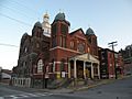
St. Adalbert Church, built in 1889, at 160 South Fifteenth Street.
-
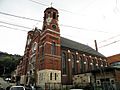
St. John the Baptist Ukrainian Catholic Church, built in 1895, at 109 South Carson Street.
-
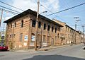
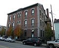
Former Garrison Foundry-Mackintosh Hemphill Company Offices, built in 1895 and 1902, at 901-911 Bingham Street.
-
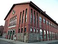
South Side High School, built in 1898, and then added to in 1924, at the corner of East Carson and South 10th Streets.
-
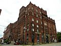
The old Duquesne Brewing Company Building, built in 1899, at Mary and 21st Streets.
-
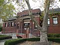
South Side Branch of the Carnegie Library of Pittsburgh, built in 1909, at 2205 East Carson Street.
-
South Side Market Building (aka the "South Side Market House"), built in 1915, at South 12th and Bingham Streets (Bedford Square).
-
Polish Army site at 97 S. 18th Street.
-
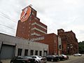
The Duquesne Brewing Company Clock (with AT&T logo on the face), built in 1933, at Mary and 21st Streets.


