Sparks, Nevada facts for kids
Quick facts for kids
Sparks, Nevada
|
|||
|---|---|---|---|
 |
|||
|
|||
| Nickname(s):
The Rail City, City of Promise
|
|||
| Motto(s):
"It's Happening Here!"
|
|||
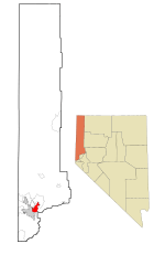
Location in Washoe County
|
|||
| Country | |||
| State | |||
| County | Washoe | ||
| Founded | 1904 | ||
| Incorporated | March 15, 1905 | ||
| Named for | John Sparks | ||
| Government | |||
| • Type | Council–manager | ||
| Area | |||
| • Total | 36.60 sq mi (94.80 km2) | ||
| • Land | 36.49 sq mi (94.51 km2) | ||
| • Water | 0.11 sq mi (0.29 km2) | ||
| Elevation | 4,413 ft (1,345 m) | ||
| Population
(2020)
|
|||
| • Total | 108,445 | ||
| • Density | 2,971.83/sq mi (1,147.42/km2) | ||
| Time zone | UTC−8 (PST) | ||
| • Summer (DST) | UTC−7 (PDT) | ||
| ZIP Codes |
89431, 89434, 89437
|
||
| Area code(s) | 775 | ||
| FIPS code | 32-68400 | ||
| GNIS feature ID | 0856391 | ||
| Reference #: | 88 | ||
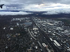
Sparks is a city in Washoe County, Nevada, United States. It was founded in 1904 and became an official city on March 15, 1905. Sparks is located just east of Reno.
In 2020, about 108,445 people lived in Sparks. This makes it the fifth largest city in Nevada. The city is named after John Sparks, who was the Governor of Nevada from 1903 to 1908. Sparks is part of the larger Reno–Sparks area.
Contents
History of Sparks, Nevada
In the past, the land where Sparks is now was home to the Washoe people. People from Europe and America started settling in the area in the early 1850s. Not many people lived there until 1904. That's when the Southern Pacific Railroad built a large area for train cars and repair shops.
The city that grew around these train facilities was first called Harriman. It was named after E. H. Harriman, who was the president of the Southern Pacific Railroad. But the city was quickly renamed Sparks after John Sparks, the governor of Nevada at that time.
Sparks stayed a small town until the 1950s. Then, as Reno grew, many new homes were built in Sparks, especially north of the railroad. In the 1970s, the area south of the railroad began to fill with warehouses and small factories.
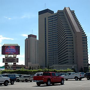
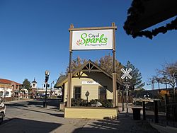
In 1984, the tall building for the Nugget Casino Resort was finished. This gave Sparks its first, and only, high-rise casino. In 1996, an area called Victorian Square became more developed. It's a place where people can walk around easily. It has a movie theater and hosts many outdoor events.
Geography and Climate in Sparks
Sparks covers a total area of about 93 square kilometers (35.9 square miles). Most of this area, about 92.6 square kilometers (35.7 square miles), is land. A small part, about 0.4 square kilometers (0.15 square miles), is water.
What is the Climate Like in Sparks?
Sparks has a semi-arid climate, which means it's quite dry. Because the air is often not very humid, especially in summer, temperatures can change a lot between day and night.
- In January, the average high temperature is about 9 degrees Celsius (48 degrees Fahrenheit). The average low is about -4 degrees Celsius (25 degrees Fahrenheit).
- In July, the average high temperature is about 33 degrees Celsius (92 degrees Fahrenheit). The average low is about 13 degrees Celsius (55 degrees Fahrenheit).
On average, there are about 60 days a year when the temperature reaches 32 degrees Celsius (90 degrees Fahrenheit) or higher. There are also about 140 days when the temperature drops to 0 degrees Celsius (32 degrees Fahrenheit) or lower.
The highest temperature ever recorded was 42 degrees Celsius (108 degrees Fahrenheit) on July 11, 2002. The lowest was -28 degrees Celsius (-19 degrees Fahrenheit) on February 7, 1989.
How Much Rain and Snow Does Sparks Get?
Sparks gets about 21.3 centimeters (8.38 inches) of rain each year. On average, there are 45 days with some rain or snow. The year 2017 was the wettest, with 31.4 centimeters (12.38 inches) of precipitation. The driest year was 2013, with only 8.3 centimeters (3.27 inches).
Sparks gets about 17.3 centimeters (6.8 inches) of snow each year. The most snow in one year was 59.2 centimeters (23.3 inches) in 2016.
| Climate data for Sparks, Nevada, 1991–2020 normals, extremes 1988–present | |||||||||||||
|---|---|---|---|---|---|---|---|---|---|---|---|---|---|
| Month | Jan | Feb | Mar | Apr | May | Jun | Jul | Aug | Sep | Oct | Nov | Dec | Year |
| Record high °F (°C) | 73 (23) |
75 (24) |
82 (28) |
88 (31) |
96 (36) |
104 (40) |
108 (42) |
102 (39) |
102 (39) |
94 (34) |
80 (27) |
68 (20) |
108 (42) |
| Mean maximum °F (°C) | 61.5 (16.4) |
65.9 (18.8) |
74.2 (23.4) |
80.6 (27.0) |
88.3 (31.3) |
95.8 (35.4) |
100.3 (37.9) |
98.5 (36.9) |
93.8 (34.3) |
84.0 (28.9) |
72.3 (22.4) |
62.7 (17.1) |
100.8 (38.2) |
| Mean daily maximum °F (°C) | 48.2 (9.0) |
52.9 (11.6) |
59.7 (15.4) |
65.0 (18.3) |
73.9 (23.3) |
83.9 (28.8) |
92.1 (33.4) |
90.8 (32.7) |
83.6 (28.7) |
71.6 (22.0) |
57.2 (14.0) |
47.0 (8.3) |
68.8 (20.5) |
| Daily mean °F (°C) | 36.5 (2.5) |
40.2 (4.6) |
45.8 (7.7) |
50.7 (10.4) |
58.5 (14.7) |
66.7 (19.3) |
73.7 (23.2) |
72.0 (22.2) |
64.9 (18.3) |
54.0 (12.2) |
43.2 (6.2) |
35.8 (2.1) |
53.5 (11.9) |
| Mean daily minimum °F (°C) | 24.7 (−4.1) |
27.4 (−2.6) |
32.0 (0.0) |
36.3 (2.4) |
43.0 (6.1) |
49.4 (9.7) |
55.4 (13.0) |
53.3 (11.8) |
46.1 (7.8) |
36.5 (2.5) |
29.2 (−1.6) |
24.5 (−4.2) |
38.2 (3.4) |
| Mean minimum °F (°C) | 9.8 (−12.3) |
13.9 (−10.1) |
19.3 (−7.1) |
23.5 (−4.7) |
31.2 (−0.4) |
36.6 (2.6) |
45.3 (7.4) |
43.8 (6.6) |
35.2 (1.8) |
24.2 (−4.3) |
14.8 (−9.6) |
9.0 (−12.8) |
5.0 (−15.0) |
| Record low °F (°C) | −3 (−19) |
−19 (−28) |
14 (−10) |
15 (−9) |
25 (−4) |
30 (−1) |
36 (2) |
38 (3) |
29 (−2) |
9 (−13) |
2 (−17) |
−17 (−27) |
−19 (−28) |
| Average precipitation inches (mm) | 1.28 (33) |
1.00 (25) |
0.85 (22) |
0.51 (13) |
0.69 (18) |
0.39 (9.9) |
0.42 (11) |
0.28 (7.1) |
0.24 (6.1) |
0.91 (23) |
0.70 (18) |
1.11 (28) |
8.38 (214.1) |
| Average snowfall inches (cm) | 2.2 (5.6) |
1.0 (2.5) |
1.0 (2.5) |
0.1 (0.25) |
0.0 (0.0) |
0.0 (0.0) |
0.0 (0.0) |
0.0 (0.0) |
0.0 (0.0) |
0.0 (0.0) |
0.8 (2.0) |
1.7 (4.3) |
6.8 (17.15) |
| Average precipitation days (≥ 0.01 in) | 6.3 | 5.7 | 5.1 | 3.4 | 4.3 | 2.5 | 1.9 | 1.8 | 1.5 | 3.1 | 4.0 | 5.4 | 45.0 |
| Average snowy days (≥ 0.1 in) | 0.9 | 1.0 | 0.5 | 0.1 | 0.0 | 0.0 | 0.0 | 0.0 | 0.0 | 0.0 | 0.4 | 0.9 | 3.8 |
| Source 1: NOAA | |||||||||||||
| Source 2: National Weather Service | |||||||||||||
People Living in Sparks
| Historical population | |||
|---|---|---|---|
| Census | Pop. | %± | |
| 1910 | 2,500 | — | |
| 1920 | 3,238 | 29.5% | |
| 1930 | 4,508 | 39.2% | |
| 1940 | 5,318 | 18.0% | |
| 1950 | 11,378 | 114.0% | |
| 1960 | 19,827 | 74.3% | |
| 1970 | 24,187 | 22.0% | |
| 1980 | 40,780 | 68.6% | |
| 1990 | 53,667 | 31.6% | |
| 2000 | 74,526 | 38.9% | |
| 2010 | 94,728 | 27.1% | |
| 2020 | 108,445 | 14.5% | |
| Source: | |||
The population of Sparks has grown a lot over the years. In 1910, about 2,500 people lived there. By 2020, the population had grown to over 108,000 people.
Who Lives in Sparks?
According to the 2020 U.S. Census, here's a look at the different groups of people living in Sparks:
- White (not Hispanic or Latino): 53.29%
- Hispanic or Latino (any race): 30.13%
- Asian: 6.58%
- Mixed race: 5.04%
- Black or African American: 2.84%
- Pacific Islander or Native Hawaiian: 0.89%
- Native American or Alaska Native: 0.82%
- Some other race: 0.42%
In 2018, about 23.5% of the people in Sparks were under 18 years old. About 15.3% were 65 years or older. More than half of the population (50.3%) were female. The average income for a household in Sparks was about $60,785 in 2018. About 9.9% of the people lived below the poverty line.
Arts and Fun in Sparks
Sparks has fun events and places for people to enjoy.
Cultural Events
One popular event is the Best in the West Nugget Rib Cook-off. This is a big outdoor cooking competition and festival.
Libraries in Sparks
Sparks has two public libraries. One is near downtown, and the other is in Spanish Springs. Both are part of the Washoe County Library System. The Sparks Library is quite large, at about 2,137 square meters (23,000 square feet).
Parks and Outdoor Activities
Sparks offers many places for outdoor fun and relaxation.
Nugget Event Center
The Nugget Event Center is a large outdoor concert area in downtown Sparks. It can hold up to 8,600 people for shows and events.
Sparks Marina Park
Sparks Marina Park is a special place built around a natural water source. You can do many water activities here, like windsurfing, sailing, swimming, and fishing. The park also has walking paths, a dog park, volleyball courts, playgrounds, and picnic areas.
Golf Courses
Sparks is home to two golf courses: Wildcreek and Red Hawk.
Education in Sparks
Public schools in Sparks are managed by the Washoe County School District. Here are some of the schools in the city:
High Schools
- Edward C. Reed High School
- Sparks High School
- Spanish Springs High School
- Hug High School
Middle Schools
- Sky Ranch Middle School
- Sparks Middle School
- Mendive Middle School
- Dilworth Middle School
- Yvonne Shaw Middle School
Elementary Schools
- Robert Mitchell Elementary School
- Alice Maxwell Elementary School
- Florence Drake Elementary School
- Greenbrae Elementary School
- Lena Juniper Elementary School
- Bud Beasley Elementary School
- Van Gorder Elementary School
- Alyce Taylor Elementary School
- Jesse Hall Elementary School
- Spanish Springs Elementary School
- Katherine Dunn Elementary School
- Miguel Sepulveda Elementary School
- Lloyd Diedrichsen Elementary School
- Excel Christian School (a private school)
Getting Around Sparks
Public Transportation
The Regional Transportation Commission of Washoe County (RTC) runs a bus system. This system connects the cities of Reno and Sparks.
Air Travel
Sparks is served by the nearby Reno–Tahoe International Airport.
Trains
The Union Pacific Railroad tracks run through the middle of Sparks, from east to west. Union Pacific has a large area for train cars and operations south of Interstate 80. This area is an important part of the city's industrial zone. Passenger train service to the Sparks Amtrak Station stopped in 2009. However, you can still catch a train in nearby Reno.
Roads
Interstate 80 goes through Sparks, running east to west. Several major roads run north and south through the city. These include:
- State Route 445 (Pyramid Way)
- El Rancho Drive
- Sullivan Lane
- Rock Boulevard
- Sparks Boulevard
- Vista Boulevard
- State Route 659 (McCarran Blvd)
Pyramid Way goes from downtown Sparks to Pyramid Lake, which is about 56 kilometers (35 miles) north. It is known as a Nevada Scenic Byway because of its beautiful views.
Sparks is also connected to south Reno by the Southeast Connector. This road helps people travel between Reno and Sparks more easily. It offers another way to get around besides busy roads like US-395/I-580 freeway.
There are also plans for a large road project to improve Pyramid Highway. This project will make it easier to connect Spanish Springs, a growing area, with the main freeway system. This will also help people travel to and from Sun Valley, another large community nearby.
Famous People from Sparks
Many notable people have connections to Sparks:
- Mädchen Amick (born 1970), actress, known for Twin Peaks
- T. J. Bell (born 1980), motorsport driver
- Bruce Breslow (born 1956), former mayor of Sparks
- Scott Cousins (born 1985), professional baseball player
- Brian Crane, cartoonist who draws Pickles
- Jacob Dalton (born 1991), Olympic gymnast
- Jim Gibbons (born 1944), former governor of Nevada
- Jena Malone (born 1984), actress, known for The Hunger Games
- Jake McGee (born 1986), professional baseball player
- Steve Portenga (born 1970), racing driver
- Brian Retterer (born 1972), NCAA champion swimmer
- Karl Rove (born 1950), political advisor
- Dan Serafini (born 1974), professional baseball player
- Vernon White (born 1971), mixed martial artist
Images for kids
See also
 In Spanish: Sparks (Nevada) para niños
 | Mary Eliza Mahoney |
 | Susie King Taylor |
 | Ida Gray |
 | Eliza Ann Grier |


