
St. Charles Streetcar Line facts for kids
Quick facts for kids St. Charles Streetcar line |
|
|---|---|

St. Charles Streetcar passing through the New Orleans Central Business District
|
|
| Overview | |
| Status | Operational |
| Owner | New Orleans Regional Transit Authority |
| Locale | New Orleans, Louisiana, USA |
| Termini | South Carrollton and South Claiborne Carondelet and Canal |
| Service | |
| Type | Streetcar using heritage streetcars |
| System | New Orleans Regional Transit Authority |
| Services | Route 12 |
| Operator(s) | New Orleans Regional Transit Authority |
| History | |
| Opened | 1835 |
| Technical | |
| Line length | 13.2 mi (21.2 km) |
| Character | Runs primarily in neutral ground (central median), except street running between Howard Avenue and Canal Street |
| Track gauge | 5 ft 2 1⁄2 in (1,588 mm) |
| Electrification | 600 V DC Trolley wire |
|
St. Charles Streetcar Line
|
|
.jpg)
A Perley Thomas streetcar on St. Charles Streetcar Line, 2021.
|
|
| Lua error in Module:Location_map at line 420: attempt to index field 'wikibase' (a nil value). | |
| Location | St. Charles Ave. route from central business district to Carrollton, New Orleans, Louisiana |
|---|---|
| Area | 15 acres (6.1 ha) |
| Built | 1835 |
| Built by | Perley A. Thomas, B. Booth & Co. |
| Architectural style | trolley system |
| NRHP reference No. | 73000873 |
| Significant dates | |
| Added to NRHP | May 23, 1973 |
| Designated NHL | August 25, 2014 |
The St. Charles Streetcar line is a very old and famous streetcar line in New Orleans, Louisiana. It has been running since 1835. This makes it the oldest streetcar line in the world that has never stopped operating! The New Orleans Regional Transit Authority (RTA) runs it.
This line is officially called Route 12. It travels along St. Charles Avenue, which is where it gets its name. Many local people and tourists use this streetcar. It is the busiest route in the RTA system. On most maps, you will see it marked in green. The streetcars on this line are also green.
Contents
What is the St. Charles Streetcar Route?
The St. Charles line begins in an area called Uptown. It starts at South Carrollton Avenue and South Claiborne Avenue. The streetcar travels along South Carrollton Avenue through the Carrollton neighborhood. It then turns onto St. Charles Avenue near the Mississippi River.
The streetcar passes by famous places like Audubon Park, Tulane University, and Loyola University New Orleans. It continues through Uptown New Orleans, including the beautiful Garden District. The line ends at Canal Street in the New Orleans Central Business District. This is right next to the French Quarter. The whole trip is about 13.2 miles (21.2 km) long.
Most of the time, the streetcar runs in the "neutral ground." This is a grassy area in the middle of the street. However, in the downtown area, it runs on the side of the street.
How Did the St. Charles Streetcar Begin?
Planning for this streetcar line started in 1831. Work began in February 1833. It was first known as the New Orleans and Carrollton Rail Road. This was the second railway built in the New Orleans area.
Passenger and freight services started on September 26, 1835. At first, it ran on public streets. Later, a special path was made in the "neutral ground" (the middle of the road). Carrollton was a separate city back then. The areas along the route were mostly empty. Two steam engines, named New Orleans and Carrollton, came from England.
From Steam to Horses and Mules
As more people moved to the area, the steam engines caused problems. They made a lot of smoke and noise. So, the streetcar company switched to cars pulled by horses and mules.
For many years, people wanted a faster way to travel than horses. They also wanted less noise than steam engines. Different systems were tried. One idea was an overhead cable system. Another idea used special engines that didn't make much smoke. These were called "fireless engines." They were even used in Paris!
The Arrival of Electric Streetcars
New Orleans first tried electric cars in 1884. This was during the World's Fair. But electric streetcars were not ready for wide use until the 1890s. The St. Charles line became electric on February 1, 1893. At the same time, the line was made longer. It went from St. Charles and Carrollton Avenues to a new car storage building at Willow Street.
Changes to the Route Over Time
In 1900, the St. Charles and Tulane streetcar lines were connected. They formed a big loop. Streetcars would leave Canal Street and go one way around the loop. Other streetcars would go the opposite way.
In 1922, the New Orleans & Carrollton Rail Road joined a bigger company. This company was called New Orleans Public Service Incorporated (NOPSI). It managed all the city's streetcar lines and electricity.
In 1950, a canal was filled in to build a highway. This changed the streetcar routes. The Tulane and St. Charles lines were separated. The St. Charles line was shortened to its current length.
Modern Updates and Accessibility
In 1972, automatic fareboxes were added. This meant streetcars no longer needed a separate conductor. The line still has one very old car from 1894. It is used for work, like sanding the tracks, but not for passengers. Most of the other cars on the line were built in 1923–24.
In 1973, the St. Charles line was recognized as a historic place. It was added to the National Register of Historic Places. Because the old cars are historic, it was hard to add wheelchair ramps. For a long time, it was the only line without wheelchair access.
In 1983, the RTA (New Orleans Regional Transit Authority) took over the streetcar line.
Recovering from Hurricane Katrina
In 2005, Hurricane Katrina caused a lot of damage. The streetcar service had to stop. Slowly, parts of the line were fixed and reopened. The entire line was back in service by June 22, 2008.
National Historic Landmark Status
In 2014, the St. Charles line became a National Historic Landmark. This means it is a very important place that shows the history of the United States. It is one of only two moving streetcar lines with this special honor. The other is the San Francisco cable car system.
Making the Streetcar Accessible for Everyone
In 2017, the RTA agreed to make the line more accessible. They planned to update six stops. They also decided to add at least one wheelchair-friendly car to the line. The old historic cars would not be changed.
In 2020, the RTA updated three streetcars. These cars were originally used on another line. They were painted green, like the St. Charles cars. They now have wheelchair access. These cars have a wheelchair symbol on them. The RTA also rebuilt six major streetcar stops. This made the St. Charles line fully accessible for people using wheelchairs. Wheelchair-accessible service started on December 1, 2020.
How Does the St. Charles Streetcar Operate?
The St. Charles Streetcar line runs all day, every day. During the daytime, a streetcar comes about every nine minutes. In the early morning and late night, they come every 18 minutes. In the middle of the night, they come every 36 minutes.
The main streetcars used are 35 cars built in 1923-24. They were made by the Perley Thomas Car Co. These cars have been repaired and updated many times over the years.
List of St. Charles Streetcar Stops
From Canal Street to Uptown
| Stop | Neighborhood(s) | Other streetcar lines | Notes | |
|---|---|---|---|---|
| Canal and Carondelet Streets | Downtown, Central Business District, French Quarter | This is where the St. Charles Streetcar line ends on the downtown side. You can transfer to the Canal Streetcar Line here. Carondelet Street turns into Bourbon Street in the French Quarter. | ||
| Traveling on St. Charles Avenue (going out) or Carondelet Street (coming in) | ||||
| St. Charles and Common Street (going out) | Downtown, Central Business District | |||
| St. Charles and Union Street (going out) Carondelet and Gravier Street (coming in) |
Downtown, Central Business District | |||
| Poydras Street | Downtown, Central Business District | This stop is near One Shell Square, the tallest building in New Orleans. | ||
| Lafayette Street (going out only) | Downtown, Central Business District | This stop is near Gallier Hall and Lafayette Square. | ||
| Girod Street | Central Business District, Arts and Warehouse District | |||
| Julia Street | Arts and Warehouse District | |||
| St. Charles and St. Joseph Street (going out) Howard Avenue and Carondelet Street (coming in) |
Arts and Warehouse District | |||
| Traveling on St. Charles Avenue from Lee Circle to Carrollton Avenue | ||||
| Lee Circle | Arts and Warehouse District | This stop is where the tracks for both directions meet. It's close to the Civil War Museum, Contemporary Arts Museum, National World War II Museum, and Ogden Museum of Southern Art. | ||
| Erato Street | Central City, Lower Garden District | |||
| Martin Luther King Jr. Boulevard/Melpomene Street | Central City, Lower Garden District | |||
| Euterpe Street | Central City, Lower Garden District | |||
| Felicity Street | Central City, Lower Garden District | |||
| St. Andrew Street | Central City, Lower Garden District | |||
| Josephine Street | Central City, Lower Garden District | |||
| Jackson Avenue | Central City, Lower Garden District | |||
| First Street | Central City, Garden District | |||
| Third Street | Central City, Garden District | |||
| Washington Avenue | Central City, Garden District | |||
| Sixth Street | Central City, Garden District | |||
| Eighth Street | Central City, Garden District | |||
| Louisiana Avenue | Milan, Tuoro | |||
| Foucher Street | Milan, Touro | |||
| Peniston Street | Milan, Touro | |||
| Constantinople Street | Milan, Touro | |||
| Milan Street | Milan, Touro | |||
| Napoleon Avenue | Milan, Touro, Uptown | |||
| Jena Street | Uptown | |||
| Cadiz Street | Uptown | |||
| Bordeaux Street | Uptown | |||
| Robert Street | Uptown | |||
| Duffosat Street (coming in only) | Uptown | |||
| Valmont Street | Uptown | |||
| Jefferson Avenue | Audubon, Uptown | |||
| Joseph Street | Audubon | |||
| Nashville Avenue | Audubon | |||
| State Street | Audubon | |||
| Webster Street | Audubon | |||
| Calhoun Street | Audubon | |||
| Exposition Boulevard | Audubon | |||
| Tulane/Loyola | Audubon | This stop is at the intersection of St. Charles and West Road. It serves Audubon Park, Tulane University, and Loyola University. | ||
| Tulane University | Audubon | This stop is at the intersection of St. Charles and Law Road. It serves Audubon Park and Tulane University. | ||
| Walnut Street | Audubon | This stop serves Audubon Park. | ||
| Broadway Street | Audubon | |||
| Lowerline Street | Audubon, Black Pearl, East Carrollton | |||
| Hilary Street | Black Pearl, East Carrollton | |||
| Burdette Street (coming in only) | Black Pearl, East Carrollton | |||
| Fern Street (going out only) | Black Pearl, East Carrollton | |||
| Traveling on South Carrollton Avenue from St. Charles to South Claiborne Avenue | ||||
| St. Charles Avenue | Black Pearl, East Carrollton, Leonidas | This stop is in the middle of Carrollton Avenue, right after the tracks turn near the Mississippi River. | ||
| Maple Street | East Carrollton, Leonidas | |||
| Freret Street | East Carrollton, Leonidas | |||
| Oak Street | East Carrollton, Leonidas | This stop is near the Oak Street shopping area. | ||
| Willow Street | East Carrollton, Leonidas | The tracks here lead to the Carrollton Station car barn. | ||
| Jeanette Street (coming in only) | East Carrollton, Leonidas | |||
| Birch Street (going out only) | East Carrollton, Leonidas | |||
| Spruce Street | East Carrollton, Leonidas | |||
| Sycamore Street | Fontainebleau/Marlyville, Leonidas | This stop serves Palmer Park. | ||
| South Claiborne Avenue | Fontainebleau/Marlyville, Leonidas | This is the last stop on the line, going out. | ||
Images for kids
-
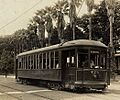
A 400 Series streetcar running on the St. Charles Avenue line in the 1910s.
-
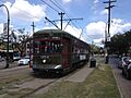
A 900 Series streetcar on the St. Charles line.
-
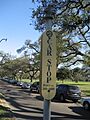
A typical streetcar stop sign along the line.
-
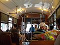
Inside a St. Charles streetcar.


