St. Paul, Alberta facts for kids
Quick facts for kids
Saint-Paul
Saint-Paul-des-Métis (1909–1936)
|
||
|---|---|---|
|
Town
|
||
| Town of St. Paul | ||

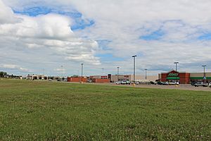
St. Paul on 40 Street south of 50th Avenue
|
||
|
||
| Country | Canada | |
| Province | Alberta | |
| Region | Northern Alberta | |
| Census division | 12 | |
| Municipal district | County of St. Paul No. 19 | |
| Founded | 1896 | |
| Incorporated | ||
| • Village | June 14, 1912 (as St. Paul de Metis) | |
| • Town | December 15, 1936 | |
| Area
(2021)
|
||
| • Land | 8.64 km2 (3.34 sq mi) | |
| Elevation | 646 m (2,119 ft) | |
| Population
(2021)
|
||
| • Total | 5,863 | |
| • Density | 678.7/km2 (1,758/sq mi) | |
| Time zone | UTC−7 (MST) | |
| • Summer (DST) | UTC−6 (MDT) | |
| Postal code span |
T0A 3A0 & T0A 4A0
|
|
| Area codes | +1-780, +1-587 | |
| Highways | Highway 29 Highway 881 |
|
St. Paul is a town in eastern Northern Alberta, Canada. It is surrounded by the County of St. Paul No. 19. The town was originally known as St-Paul-de-Métis or St-Paul-des-Métis from 1912 to 1936.
The area where St. Paul is located has a special history with the Métis people. Métis families were among the first to settle here. They played a big part in the fur trade and helped develop the region. The Métis people have both Indigenous and European ancestors. They added a lot to the culture of the area.
The town's name comes from a Catholic mission and church built in the late 1800s. This church was named after Saint Paul the Apostle. It became a central place for the local Métis community. People gathered there for religious, social, and cultural events.
Contents
History of St. Paul
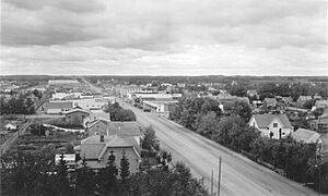
St. Paul began as a Métis settlement in 1896. A missionary named Albert Lacombe asked the Canadian government for land. He wanted this land to be set aside for Métis families to farm. The settlement was called Saint-Paul-des-Métis. It was on four areas of government land, leased for 99 years at a low cost.
Each Métis family received 80 acres of land. They also got livestock and farming tools. There was also shared land for everyone to use. Soon, a chapel, a school, a sawmill, and a windmill were built.
However, the settlement faced many challenges. There were bad storms and a fire in 1905. These problems led to the colony failing. The government lease ended in 1908.
One building from the original settlement is still standing today. It's called the Old St. Paul Rectory. This building was the main office for the Oblate priests. It is now recognized as an Alberta Provincial Historical Resource.
After the Métis settlement ended, the area was opened to other Canadians. In 1909, many French-Catholic Canadian families settled there. The community became the Village of St. Paul de Métis on June 14, 1912. Later, on December 15, 1936, it became the Town of St. Paul. At this time, the name "Métis" was removed. In 1920, the community built a 48-kilometer railroad track. This connected the village to the main Canadian railway system.
Population in St. Paul
In the 2021 Census, the Town of St. Paul had 5,863 people living there. This was a small increase from its 2016 population of 5,827. The town covers an area of 8.64 square kilometers. This means about 678 people live in each square kilometer.
Most people in St. Paul are of European background, about 71%. Indigenous people make up the next largest group, about 16% of the population. Most Indigenous residents are Cree or Métis. About 12.3% of the population are visible minorities. The largest group among them are Filipino Canadians.
Economy of St. Paul
The economy of St. Paul mainly relies on agriculture and service industries. Agriculture means farming and related activities. Service industries include businesses that provide services, like shops and restaurants. St. Paul is also part of Alberta's Lakeland tourism area. This means tourism is important for the town.
Fun Places to Visit
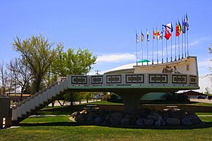
St. Paul is famous for having the world's first UFO landing pad! It was built in 1967 as part of Canada's 100th birthday celebrations. The idea was to attract both tourists and even visitors from other planets!
The landing pad is a big platform weighing 30 tonnes. It has a map of Canada on its back wall. This map is made from stones from every Canadian province. On June 3, 1967, the Minister of National Defence, Paul Hellyer, officially opened the pad.
The UFO landing pad was one of over 100 special projects the town organized. The idea came from the former town Mayor, Jules Van Brabant, and some local business owners. Local construction companies donated the materials. A local designer created the mushroom-shaped design.
A sign next to the pad shares a special message. It says the area is "international" and hopes for peace in space. It welcomes all visitors, from Earth or other galaxies, to the town. The UFO landing pad was even visited by Queen Elizabeth II and Prince Philip in 1978.
Famous People from St. Paul
- Ryley Barnes, a former professional volleyball player
- Kyle Brodziak, a professional hockey player
- Greg Evtushevski, a professional hockey player
- Alex Janvier, an Indigenous visual artist
- Brett Kissel, a professional country singer and songwriter
- Wilf Martin, a former professional hockey player
- Audrey Poitras, a former president of the Métis Nation of Alberta
- Marcel Rocque, a curler
- Jamie Sadlowski, a former professional long driver and golfer
- Stan Smyl, a former professional hockey player
- Bernard Trottier, a politician
- Calvin Vollrath, a professional fiddler and composer
 | Dorothy Vaughan |
 | Charles Henry Turner |
 | Hildrus Poindexter |
 | Henry Cecil McBay |


