
St. Stephan, Switzerland facts for kids
Quick facts for kids
St. Stephan
|
||
|---|---|---|

St. Stephan village
|
||
|
||

St. Stephan
Location in Switzerland

St. Stephan
Location in Canton of Bern
|
||
| Country | Switzerland | |
| Canton | Bern | |
| District | Obersimmental-Saanen | |
| Area | ||
| • Total | 60.89 km2 (23.51 sq mi) | |
| Elevation | 1,008 m (3,307 ft) | |
| Population
(Dec 2020 )
|
||
| • Total | 1,310 | |
| • Density | 21.51/km2 (55.72/sq mi) | |
| Postal code |
3772
|
|
| Surrounded by | Zweisimmen, Diemtigen, Adelboden, Lenk and Saanen | |

St. Stephan is a small town, also called a municipality, in the Bern canton of Switzerland. It is located in the Obersimmental-Saanen administrative district. The town is named after Saint Stephen, a very early Christian martyr.
Contents
A Look at St. Stephan's History

St. Stephan was first mentioned in records in 1352 as Sant Stephan.
The village started as a royal estate belonging to the Burgundian royal family. This estate was important because it was located in a mountain pass leading to Valais. In 994, the royal family gave St. Stephan to Selz Abbey, which was a monastery. Over time, the village became part of the lands owned by the Freiherr of Raron. Later, in 1456, it went to the Bubenberg family. Finally, in 1494, the city of Bern took control of St. Stephan.
The village church of St. Stephan was built a very long time ago, in the Early Middle Ages. The first church building was updated and made bigger in the 12th and 15th centuries. At first, it was a smaller church connected to the main church in Zweisimmen. In 1335, Interlaken Monastery became responsible for the church. In the 1400s, the people of St. Stephan wanted to have their own church parish, separate from the monastery. Even though the Pope and the Council of Basel agreed, the monastery kept control. Finally, in 1525, the villagers were allowed to form their own parish.
Three years later, in 1528, Bern adopted the new Protestant Reformation faith. Interlaken Monastery and most of the Bernese Oberland region did not want to change their religion. However, Bern made the Oberland, including St. Stephan, switch to the new faith that same year.
For a long time, the people of St. Stephan grew crops in the valley for their own food. Starting in the 1500s, they began trading for grain from other cities. They also started raising cattle for meat, milk, and cheese. They kept cattle both in the valley and in seasonal camps high in the mountains.
In 1912, a railroad connected St. Stephan to Zweisimmen. This brought many tourists to the mountain village. During World War II, in 1944, a military airport was built in the town. In the late 1990s, it became a civilian airport. Today, some people in St. Stephan still raise cattle or make cheese. Many also work in the tourism industry. About one-third of the working people travel to Zweisimmen or other nearby towns for their jobs.
Exploring St. Stephan's Geography
_038.jpg)
St. Stephan covers an area of about 60.9 square kilometers (23.5 square miles). About half of this land (50.6%) is used for farming. A large part (31.8%) is covered by forests. A smaller amount (2.4%) has buildings or roads. Very little (0.7%) is rivers or lakes. The rest (14.3%) is unproductive land, like rocky areas.
St. Stephan is located in the Bernese Oberland region, in the Simmental valley. It lies between the towns of Zweisimmen and Lenk. The municipality also includes a tall mountain called Albristhorn, which is 2,762 meters (9,062 feet) high.
The municipality is made up of several cooperative farming villages. These include Ried, Häusern, Grodey, Matten, Fermel, Obersteg, and Zu Hähligen. Interestingly, there isn't one specific place called "St. Stephan" itself; the name refers to the whole group of villages.
At the bottom of the valley, there is a paved airfield that is 2,050 meters (6,726 feet) long. It was originally built for the military but is now used for both civilian and military flights.
St. Stephan's Coat of Arms
The coat of arms for St. Stephan shows a picture of Saint Stephen. He is walking on a green hill. He has a golden halo around his head and is wearing purple clothes. In one hand, he holds an open red book, and in the other, he holds a green palm branch. He also carries a pouch with stones in it.
People and Population
_040.jpg)
As of 2011, St. Stephan had a population of 1,366 people. About 8.9% of these people were foreign nationals living in the town.
Most people in St. Stephan (about 95.7%) speak German as their main language. Albanian is the second most common language, followed by Serbo-Croatian.
In 2011, children and teenagers (ages 0-19) made up 22.5% of the population. Adults (ages 20-64) made up 57.4%, and seniors (over 64 years old) made up 20.1%.
Many people in St. Stephan were born there. In 2000, about 55.8% of the people living in St. Stephan were also born there.
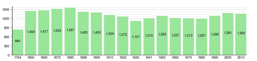
The population of St. Stephan has changed over time, as shown in the chart below:
Economy and Jobs

In 2011, St. Stephan had a low unemployment rate of 1.28%. This means most people who wanted jobs had them.
In 2008, there were 548 people working in the town.
- About 262 people worked in the primary sector, which includes farming and forestry.
- About 154 people worked in the secondary sector, like manufacturing and construction.
- About 132 people worked in the tertiary sector, which includes services like tourism, shops, and hotels.
Many people who live in St. Stephan also work there. In 2000, about 79.4% of the workers both lived and worked in the municipality. However, more people leave St. Stephan for work than come into it. About 15.1% of working people used public transportation to get to work, while 55.2% used a private car.
Religion in St. Stephan
Based on a 2000 survey, most people in St. Stephan (74.2%) belonged to the Swiss Reformed Church, which is a Protestant church. About 4.8% were Roman Catholic. A smaller number of people belonged to other Christian churches or were Muslim. About 3% of the population did not belong to any church.
-
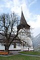
St. Stephan Church
-
Inside the church
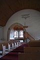
-
Stained glass windows in the church
-
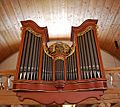
The church organ, built in 1778


Education and Schools
In St. Stephan, about 50.8% of the people have finished non-mandatory upper secondary education. This is like high school. About 9.3% have gone on to higher education, like a university.
The school system in the Canton of Bern starts with one year of optional Kindergarten. After that, there are six years of Primary school. Then, students go to three years of lower Secondary school. In secondary school, students are grouped based on their abilities. After lower secondary, students can continue their schooling or start an apprenticeship to learn a trade.
During the 2011-2012 school year, 97 students attended classes in St. Stephan. There was one kindergarten class with 22 students and three primary classes with 70 students. There was also one lower secondary class with 5 students.
Notable People from St. Stephan
- August Fetscherin (1849–1882) was a Swiss doctor. He was known for being the first Swiss doctor to study how a young girl developed after having her thyroid gland removed.
See also
 In Spanish: Sankt Stephan para niños
