
St Helen's, Isles of Scilly facts for kids
|
Enys Elyd
|
|
|---|---|

St Helen's
|
|

St Helen's
Location in Isles of Scilly
|
|
| Geography | |
| Coordinates | 49°58′23″N 6°19′30″W / 49.973°N 6.325°W |
| OS grid reference | SV900170 |
| Archipelago | Isles of Scilly |
| Area | 0.073 sq mi (0.19 km2) |
| Administration | |
|
United Kingdom
|
|
| Civil parish | Tresco |
| Demographics | |
| Population | 0 |
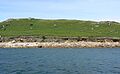
St Helen's (Cornish: Enys Elyd or Enys Elidius) is one of the many islands in the Isles of Scilly that no one lives on. It covers about 0.1885 square kilometers (0.073 square miles). On the south side of the island, you can find one of the oldest Christian sites in Scilly. This is an old religious area from the early Middle Ages. People believe it's what's left of St Elidius Hermitage, an 8th-century chapel. A saint named Saint Lide (also known as Elid or Elidius) is thought to have lived there.
The island also has the remains of an old hospital. This hospital was used to keep sailors with the plague separate from others. St Helen's is a big part of a special protected area called a Site of Special Scientific Interest. Some parts of it are even protected as ancient monuments. You can get to the island by hiring a boat or by taking special trips during the summer. The Isles of Scilly Wildlife Trust looks after St Helen's today.
Contents
Island Geography: Where is St Helen's?
St Helen's is the third largest island that no one lives on in the Isles of Scilly. It's located in the northern part, between the islands of Tresco and St Martin's. The island covers about 18.85 hectares (46.6 acres) and rises to 42 meters (138 feet) high.
Some smaller islands nearby are considered part of the St Helen's group. These include Foreman's Island, Men-a-vaur, Northwethel, Round Island, and Teän. The island is mostly made of a type of rock called granite. You can land on a sandy beach on the south side. Here, you'll see what's left of a granite dock and small sand dunes. The old hospital building is on a flat area behind these dunes. Further inland, the religious site is at the bottom of the hill. To the east of this site, there's an old well and walls from old fields.
Ancient History: What are Cairns?
Bronze Age Cairns on St Helen's
The stone piles called cairns on St Helen's are a big part of the 387 cairns still found on the Isles of Scilly. Because of this, they are protected as ancient monuments. These cairns were built during the Bronze Age. On the island, there are four special "ring cairns" on a gentle slope facing northwest.
The first cairn is 4 meters (13 feet) wide. It has a ring of earth with stones sticking out, about 1 meter (3 feet) wide and 0.2 meters (0.7 feet) high. The second cairn is oval, 4 meters (13 feet) by 3 meters (10 feet), with a ring 0.4 meters (1.3 feet) wide and 0.2 meters (0.7 feet) high. It includes two flat stones placed on their edges. The third cairn is 6 meters (20 feet) wide with a ring of stones about 1 meter (3 feet) wide and 0.3 meters (1 foot) high. The fourth cairn is 4 meters (13 feet) wide, with a ring of stones about 0.7 meters (2.3 feet) wide and 0.2 meters (0.7 feet) high.
Island History: From Hermits to Hospitals
Early Christian Chapel: A Place of Worship
On the south side of St Helen's, there's an old religious site from the early Middle Ages. People believe it's what's left of St Elidius Hermitage, an 8th-century chapel. Saint Lide (also known as Elid or Elidius) is thought to have lived there and possibly been buried there.
Archaeologists have dug up the site and found that it started as a place for a single hermit. It had one round hut and a small prayer room. Later, it grew into a shared hermitage with several rectangular huts for people to live in, surrounding a church and prayer rooms. Five graves from the early hermitage were also found east of the living area. There was also a system of fields to grow food for the hermitage and later for the people at the Pest House.
In the early 11th century, a small church was built. Around 1120 AD, this church was given to Tavistock Abbey. This meant more pilgrims visited the site because it was a shrine to Saint Elidius. Many changes were made to the site over time. Digs have also found decorated roof tiles and parts of a 12th-century marble shrine. This shrine is believed to have once held Saint Elidius's relics (special objects connected to a saint). People also say there was once a path from the abbey church at Tresco to the church on St Helen's Isle. Today, there's an outdoor church service every year on August 8th to celebrate the feast of St Elidius at the small ruined church.

St Helen's Pool: A Safe Harbor
St Helen's Pool is an area of water near St Helen's island. It was a safe place for ships to anchor, even though ships might feel some rocking from the waves when the tide is high.
There's proof that in the later Middle Ages, the monks from Tresco might have collected fees from ships for anchoring in St Helen's Pool. This is because it was thought to be the main harbor for the islands during medieval times.
The Pest House: An Old Hospital
St Helen's Isolation Hospital, also called the Pest House, was a special station built in 1764. Its job was to keep people with the plague separate from others. These were usually sailors from ships visiting Old Grimsby and St Helen's Pool. It was built after a law was passed in 1754. This law said that any ship with the plague, coming from north of Cape Finisterre and heading for England, had to anchor off this island.
The station included the hospital building, a slipway (a ramp for boats), and a large quay (a dock) to serve it. The pest house was still used to take patients from ships that were kept separate. The hospital building is a rectangular building without a roof. It is 7 meters (23 feet) by 5.5 meters (18 feet) on the outside, with a two-room part on its east side. The walls are 0.6 meters (2 feet) wide and 3 meters (10 feet) high. They are made of stones held together with mortar. The building has recently been fixed and made stable so it doesn't fall down. This was done with help from English Heritage. There is also a graveyard near the pest house. It is known to have the grave of a 27-year-old naval surgeon who was sent to help the sick but died himself within a week. Many passengers from Africa and Asia who also died at the station are buried there.
Island Wildlife: Plants and Animals
The island is part of the St Helen's (with Northwethel and Men-a-vaur) Site of Special Scientific Interest (SSSI). It's special because of its rare plants and the seabirds that nest there. The SSSI was first recognized in 1971 and covers all the land above the average high-water mark.
Flora: The Plants of St Helen's
In 1940, the highest land on St Helen's was covered in a type of plant community called maritime heath. It had plants like ling (Calluna vulgaris) and bell heather (Erica cinerea). But this was destroyed by fires from bombs dropped by German planes during World War II. There were more fires in the dry weather of 1949. When a plant expert named J E Lousley studied the plants in 1957, the soil was very thin, only one or two inches deep, grey, and full of granite chips. The most common plants were buck's-horn plantain (Plantago coronopus) and English stonecrop (Sedum anglicum). The fires likely also affected the number of lichens and mosses.
By 1971, the plants had still not returned to how they were before the fires. By 1987, a plant called Hottentot fig (Carpobrotus edulis) had spread over much of the area. By 2002, much of this plant had disappeared, possibly because of salt spray or very cold weather. In the last SSSI check in 2009, the plants on the island, including the heath, were thought to be in "a favourable condition," meaning they were doing well. Lousley also found large areas of cliffs and rocks covered with Hottentot fig. This plant spreads when gulls carry it to their nests. It can then grow and spread over bare ground and other plants.
The lower land on the south side of the hill has deeper soil with black humus (decayed plant matter) and white sand. This area is mostly covered by a thick growth of bracken (Pteridium aquilinum) and bramble (Rubus ulmifolius). It has more types of plants compared to many other islands. This is probably because St Helen's is more protected from salt spray since it's surrounded by other islands. Also, people have lived on the island for a long time, which has allowed new plant species to grow. This could be from people bringing them or from animals grazing (eating plants), which helped create deeper soils on the lower ground.
Around the old hospital, there's tall grass and bushes with flowering plants like hemlock (Conium maculatum), hogweed (Heracleum sphondylium), and good numbers of balm-leaved figwort (Scrophularia scorodonia). It's unusual for a small island in Scilly to also have grey willow (Salix cinerea), wood spurge (Euphorbia amygdaloides), and small reed (Calamagrostis epigejos). In the past, the areas around the buildings would have been farmed or grazed by animals. To let visitors get to the August church service, the tall plants are cut around the ruined buildings and on the path from the landing place.
On the northwest side of the island, there's an area of grassland near the sea. It has lots of thrift (Armeria maritima), sea beet (Beta vulgaris subsp. maritima), and tree mallow (Lavatera arborea). Also on the north side, directly across from Round Island, an expert named Issac North found a deep crack in the rocks in 1850. This crack was richly covered in sea spleenwort (Asplenium marinum).
Shore Dock: A Rare Plant
Shore dock (Rumex rupestris) is one of the rarer types of docks and is a special plant listed in the United Kingdom Biodiversity Action Plan (BAP). It's one of the reasons why the Isles of Scilly is a Special Area of Conservation (SAC). It was seen in 1957 by Lousley, but it hasn't been seen since and is thought to be gone from St Helen's. However, it was seen nearby on Teän in 2005.
Fauna: The Animals of St Helen's
It's often hard to record the animals on the outer islands of the Isles of Scilly. This is because they are difficult to reach and people don't spend much time there.
Mammals on St Helen's
St Helen's has a long history of people living there. When Issac North visited the islands in 1850, he reported seeing goats and deer. The deer were still there in 1865, and in 1870, sheep were said to be running wild. A guide book from 1919 said that St Helen's only animals were goats, deer, rabbits, and sea birds. The Scilly shrew (Crocidura suaveolens) was seen on low cliffs in 1964. Rabbits haven't been seen since 1980.
Birds of St Helen's
In 2006, Cooper recorded a few great black-backed gulls (Larus marinus) nesting. There were also some herring gulls (Larus argentatus) and a small group of kittiwakes (Rissa tridactyla) on the eastern cliffs. Parslow (2007) recorded a large group of lesser black-backed gulls (Larus fuscus) and a small group of puffins (Fratercula arctica). A survey in 2000 found five active nests of Manx shearwaters (Puffinus puffinus).
Other Islands in the St Helen’s Group
Foreman’s Island
Foreman's Island is a low-lying island covering 0.37 hectares (0.91 acres). It's located on the south side of St Helen's Pool, between Teän and Tresco. It's one of several rocks and small islands important for seabirds that nest there. The common froghopper (Philaenus spumarius) has been found on Foreman's Island.
Men-a-vaur
Men-a-vaur is northwest of St Helen's. It's made up of three large granite rocks covering 0.55 hectares (1.4 acres) and rising to 38 meters (125 feet) high. It's part of the SSSI because of its seabirds, with eight different species nesting there. The number of razorbills (Alca torda) is very important for the country. Along with fulmars (Fulmaris glacialis) and guillemots (Uria aalge), these are the largest groups in the Isles of Scilly. Other birds include kittiwake, great black-backed gull, lesser black-backed gull, herring gull, shag (Phalacrocorax aristotelis), and puffin. Peregrine falcons (Falco peregrinus) and ravens (Corvus corax) also nest there in some years.
Lousley recorded common scurvygrass (Cochlearia officinalis), tree mallow, and a type of orache (Atriplex spp). However, flowering plants don't always stay there. A rare rove beetle called (Omalium allardi) has also been found.
Northwethel
Northwethel is an island covering 4.63 hectares (11.4 acres) and standing 15.2 meters (50 feet) high. It's in Old Grimsby Channel, near Grimble Porth, Tresco. The island has two hills connected by a low stretch of land. There's a sandy beach where you can land on the south side, and a small pool of slightly salty water behind the sea bank.
People have lived on Northwethel since the Bronze Age. There's a field of up to nine cairns, including one with a chamber 5.5 meters (18 feet) wide. Two cover stones are still in place. The chamber is 3.0 meters (10 feet) long, 1.36 meters (4.5 feet) wide in the middle, and 0.45 meters (1.5 feet) at the entrance. There's also an old field system and a settlement with probably six hut circles (round stone foundations of old huts). Some of these hut circles are built into the field walls. There are three or four unevenly shaped fields, 30.0 meters (98 feet) to 50.0 meters (164 feet) across. The hut circles are 4.0 meters (13 feet) to 6.0 meters (20 feet) wide inside. Many old items like flint, bone, and pottery have been found here and are now at the Isles of Scilly Museum on St Mary's.
It is said that 1,500 Parliamentarian soldiers landed on the island, thinking they were on Tresco. A roughly rectangular area with two drystone walls might be a "Parliamentary army shelter." On the west side of the island, you can see the remains of a rusty ship.
The botanist J E Lousley visited the island in May 1957. He found fifty-four types of plants, even though most of the island was covered in a thick tangle of bracken and bramble up to 1 meter (3 feet) high, making it hard to walk through. Unusual plants (for the Isles of Scilly) found in the slightly salty pool include sea-milkwort (Glaux maritima), fennel-leaved pondweed (Stuckenia pectinata), and red goosefoot (Chenopodium rubrum). A visit by John Hunt in the 1980s found a "healthy" growth of bracken. The fern soft shield-fern (Polystichum setiferum), once thought to be very rare on the islands, has now been found on all the islands where people live (except Bryher) and also on Northwethel.
Round Island
Round Island is an island covering 4.09 hectares (10.1 acres) to the north of St Helen's. It has an unmanned lighthouse at its highest point. It's part of the Pentle Bay, Merrick and Round Islands Site of Special Scientific Interest (SSSI).
Teän
Teän is an island covering 16.13 hectares (39.9 acres). It's located between St Helen's to the northwest and St Martin's to the east. The island has a long history of people living there and was named the Teän Site of Special Scientific Interest (SSSI) in 1971. It's also included in the Isles of Scilly Geological Conservation Review because islands are linked by a sandy bar or tombolo there.
Images for kids
-
St Helen's
-
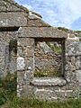
The Ruined Pest House, St Helen's
