
St John's, Worcester facts for kids
Quick facts for kids St John's |
|
|---|---|
 St John's Church |
|

St John's
|
|
| Population | 8,982 2021 Census |
| • London | 137 mi (220 km) SE |
| District | |
| Shire county | |
| Region | |
| Country | England |
| Sovereign state | United Kingdom |
| Post town | Worcester |
| Postcode district | WR2 |
| Dialling code | 01905 |
| Police | West Mercia |
| Fire | Hereford and Worcester |
| Ambulance | West Midlands |
| EU Parliament | West Midlands |
| UK Parliament |
|

St John's is a lively area in the west of Worcester, England. It's located in Worcestershire, just west of the city centre and the River Severn. People often call St John's the "Village in the City." This is because it used to be a separate town before it became part of Worcester in 1837. Even today, the people who live here feel like they belong to a special community.
St John's is one of the fifteen areas, called wards, that make up the city of Worcester. It is about 1.2 kilometers (less than a mile) west of the city centre. The main road, the A44, runs through St John's. This road is the most direct way to get from Worcester city centre to Hereford. The area includes the streets around St John's Church, like Bromyard Road, Bransford Road, and Bromwich Lane. Sometimes, the whole area west of the River Severn is called St John's. This includes the University, the Worcestershire County Cricket Club ground, and Cripplegate Park.
Contents
What's in a Name?
The name St John's probably comes from John the Baptist, a very important saint. The full name of the local church parish is 'St John-in-Bedwardine,' which also refers to John the Baptist.
A Glimpse into History

St John's played a part in the English Civil War, a big conflict in England's past. A leader from the Parliament's side, named Charles Fleetwood, managed to cross the River Teme. He then pushed his way into St John's, forcing the King's soldiers to retreat.
Parliamentary soldiers damaged the nearby parish church. They even used its walls to sharpen their weapons, and you can still see the marks on the stone today! The church tower was used as a lookout spot. However, the spire was shot off by cannon fire, likely from Oliver Cromwell's army. After the war, Parliament gave money to help fix the church.
Parts of the St John in Bedwardine Parish Church date back to the late 1100s. However, much of the church was rebuilt in the 1800s.
St John's was once a town on its own, only becoming part of Worcester in 1837. It grew because it was on important roads leading west from the city towards Mid Wales. It was also close to the River Severn Bridge, a key crossing that connected Worcester to western parts of the country. This location attracted many people to trade and live in St John's. The area even offered places for Welsh traders to stay, as they weren't allowed to sleep on the streets inside the city walls. St John's had its own market and a bullring, which helped it stay independent from the city. The bullring was outside the city walls.
In more recent times, St John's has become home to many students. This is because the University of Worcester has grown a lot. St John's was also the first area in Worcester to have tall apartment buildings, known as high-rise flats.
People of St John's
The 2021 Census showed that St John's is a diverse area. Most residents (93.9%) are White British. Other groups include 2.2% Mixed, 1.8% Asian, and 1.5% Black. When it comes to religion, 50.8% of people said they were Christian. About 46.8% said they had no religion, and 1.1% were Muslim. Other religions made up less than 1%.
Getting Around St John's
Walking and Cycling
You can easily walk or cycle towards the city centre. One popular route goes through Cripplegate Park. Another path takes you past the Worcestershire County Cricket Club ground and over the Worcester Bridge, which crosses the River Severn. From the Worcester Bridge, you can enjoy beautiful views of Worcester Cathedral. There's also the Sabrina Bridge, which was updated in 2020, located near the Worcester Arena.
Buses
St John's has many bus stops, and three public bus routes pass through the area.
- The No. 44 bus, run by First Midlands, takes passengers from Crowngate Bus Station in Worcester to Malvern, Worcestershire.
- The 31, 31b, and 31c buses travel from the University of Worcester to the city centre.
Old Railway Station
St John's used to have its own railway station called Henwick Railway Station. It was on the line to Malvern and Hereford. It also served trains on a branch line that no longer exists, which went to Bromyard. The station closed on April 3, 1965. It's unlikely to reopen because a nursing home was built on the old site. However, the Signal Box and Level Crossing are still there.
St John's Geography
The Heart of the Suburb

The main part of St John's includes the A44 (Bromyard Road) and the B4206 (Malvern Road). The B4485 (Bransford Road) connects to Malvern Road. The A44 rises a bit from New Road. This helps it avoid the frequent flooding that affects the New Road cricket ground and nearby sports fields. In the past, floods on New Road often cut off access between Worcester City Centre and St John's. However, road improvements in 2018 raised the level of New Road, making sure access is maintained.
In St John's, you'll find large buildings like Sainsbury's and Aldi supermarkets. There are also three tall apartment buildings, a sports centre, a Catholic church, a Church of England church, and a library. You can also find a post office, dentists, a chiropractic clinic, barbers, butchers, and many other local shops.
An important landmark is the Church of St John in Bedwardine, which is a Church of England church.
Weather in St John's
St John's usually has a mild climate with warm summers and gentle winters. However, it can experience more extreme weather. Flooding around New Road is often a problem. In the winters of 2009–10 and 2010–11, the area had long periods of very cold temperatures and heavy snow. The River Severn, close to St John's, even partly froze over in Worcester during these cold spells. On the other hand, Worcester recorded a very hot temperature of 37 °C (99 °F) on August 3, 1990.
| Climate data for Worcester | |||||||||||||
|---|---|---|---|---|---|---|---|---|---|---|---|---|---|
| Month | Jan | Feb | Mar | Apr | May | Jun | Jul | Aug | Sep | Oct | Nov | Dec | Year |
| Mean daily maximum °C (°F) | 8 (46) |
9 (48) |
11 (52) |
14 (57) |
18 (64) |
20 (68) |
23 (73) |
23 (73) |
19 (66) |
15 (59) |
11 (52) |
7 (45) |
15 (59) |
| Mean daily minimum °C (°F) | 3 (37) |
4 (39) |
4 (39) |
6 (43) |
8 (46) |
12 (54) |
13 (55) |
13 (55) |
11 (52) |
8 (46) |
6 (43) |
4 (39) |
8 (46) |
| Average precipitation mm (inches) | 63.2 (2.49) |
51.2 (2.02) |
46.5 (1.83) |
77.7 (3.06) |
45.9 (1.81) |
52.3 (2.06) |
43.3 (1.70) |
53.9 (2.12) |
63.4 (2.50) |
93.3 (3.67) |
69.5 (2.74) |
77.8 (3.06) |
738 (29.1) |
Fun and Leisure
Cripplegate Park
In 1878, a law was passed that said land, now known as Cripplegate Park, would become a public park for everyone to enjoy. In the 1940s, a bowling green was added, and it's still there today. There's also a bowling alley along the Bromyard Road.
There used to be a unique, almost circular house in the park. It had been a café, a library, a place to get ration books, and a clinic. It seemed to be the caretaker's house for the park, which used to be its garden and farmland. There was even a paddling pool for visitors. The house and paddling pool were removed when the tall apartment buildings were built and the roads were changed.
Today, the park has public tennis courts and an interactive game. The Worcester Music Festival is held there every August.
The Fountain
The fountain in the park was made in 1858 by Hardy & Padmore. It was first meant to help cool down the market hall. However, it was found to be leaking, and the market hall needed a lot of money for repairs. So, after a year, the fountain was moved and set up in the park for £300. It was fixed up in 2004 for £28,000, and the lion masks on it were replaced.
Learning in St John's
Primary Schools

St John's is home to a few of Worcestershire's primary schools. The most central one is Our Lady Queen of Peace RC Primary School, which opened in 1971. Its school uniform is mainly purple. Other primary schools nearby include Pitmaston Primary School, Oldbury Park Primary School, and St. Clement's Primary School.
High Schools
The only high school in St John's is Christopher Whitehead Language College. It was formed in 1983 when a boys' school and a girls' school joined together. It teaches about 1100 students, both boys and girls. In 2005, the school became a language college. It has sports fields near the river and also uses modern artificial turf pitches on its own site. The school also uses the facilities at the St John's sports centre, which is right next door. You can enter the school from Malvern Road or the A44.
The University

The University of Worcester officially became a university in 2005. Its main campus, located on the west side of the River Severn, is called the St John's Campus. This is likely because it's so close to the St John's area. The University has many facilities, including two full-size artificial turf pitches for hockey and football. Around 18,000 students have graduated from the University. Its excellent science facilities, especially the Darwin Building, are known for making it one of the best learning places in the UK.
A big expansion for the University happened in 2010 when they opened their Business School in the city centre. This school is in a beautiful Georgian building that used to be the city hospital. Next to this building is The Hive, which is Europe's first library that is both a university library and a public library. The Queen opened it in 2012.
Sports in St John's
Worcestershire County Cricket Club

Worcestershire County Cricket Club has been a part of St John's since 1896. That's when they first played at New Road, which is still their home ground today. The club has a rich history and has been home to many famous cricketers like Graeme Hick and Moeen Ali. The New Road ground often floods in winter because it's so close to the river. It was badly affected by floods in July 2007, which caused several matches to be cancelled.
Famous singer Elton John even played a concert at the ground in 2006.
Worcester Wolves Basketball

In May 2000, the Worcester Wolves Basketball Team was formed. They started playing at the University of Worcester's new sports hall. Twelve years later, the club became part of the top league in British Basketball. The club's growth is largely thanks to the development of the University of Worcester. Many fans are from St John's because the team worked with local schools early on. Players from the team would run after-school basketball sessions at schools like Oldbury Park Primary School. This encouraged many students to go and watch their coaches play at the University of Worcester, where the Wolves are based. A new sports building, the Worcester Arena, was built by the riverside in 2012. It can hold 1,500 people. Since the 2013/2014 season, it has been the home for the Worcester Wolves' games.
Worcester St Johns Cycling Club
The Worcester St Johns Cycling Club was started in 1888. It has always been a racing club and found success early on. Ernest Payne joined the club in 1903 and went on to win an Olympic Gold Medal at the London Games in 1908.
Oldbury Park Tigers Football Club
Oldbury Park Tigers FC is a community football club that has many different youth teams across the city. It was created in 2001 when a group of parents and students from Oldbury Park Primary School set up the team. Since it started, it has grown to have 11 teams and over 140 players. It is currently sponsored by The Co-operative, which has a supermarket in St John's.
Images for kids
-
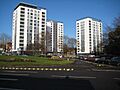
High-rise flats in St John's, Worcester

