Stanfield, Oregon facts for kids
Quick facts for kids
Stanfield, Oregon
|
|
|---|---|

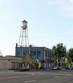
Buildings and water tower in Stanfield
|
|

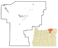
Location in Oregon
|
|
| Country | United States |
| State | Oregon |
| County | Umatilla |
| Incorporated | 1910 |
| Area | |
| • Total | 1.73 sq mi (4.47 km2) |
| • Land | 1.73 sq mi (4.47 km2) |
| • Water | 0.00 sq mi (0.00 km2) |
| Elevation | 591 ft (180 m) |
| Population
(2020)
|
|
| • Total | 2,144 |
| • Density | 1,241.46/sq mi (479.37/km2) |
| Time zone | UTC-8 (Pacific) |
| • Summer (DST) | UTC-7 (Pacific) |
| ZIP code |
97875
|
| Area code(s) | 541 |
| FIPS code | 41-69900 |
| GNIS feature ID | 2411967 |
Stanfield is a city located in Umatilla County, Oregon, in the United States. In 2010, about 2,043 people lived there. By 2020, the population had grown to 2,144. Stanfield is part of the larger Pendleton and Hermiston area, which is a group of towns connected by their economy.
Contents
Geography of Stanfield
Stanfield is located in the state of Oregon. The United States Census Bureau says that the city covers about 1.53 square miles (3.96 square kilometers). All of this area is land, meaning there are no large lakes or rivers within the city limits.
History of Stanfield
The place where Stanfield is now was first called "Foster." It was named after John R. Foster from Portland. He worked with a company called Allen & Lewis. This company bought a large piece of land, about 4,000 acres, northeast of Echo.
They started a big ranch there. Soon, a store and a small community grew up around the ranch. Everything was named after Mr. Foster. In 1882, a train stop and siding for the Oregon Railway & Navigation Company were also named "Fosters."
A post office, which is where mail is handled, was opened in 1883 and also called Foster. However, the name of the town changed in 1909 to Stanfield. It was renamed after Robert N. Stanfield Jr.. He later became a U.S. senator for Oregon. A U.S. senator is a person elected to represent their state in the United States Congress.
Population Changes in Stanfield
The population of Stanfield has changed a lot over the years. Here's how many people have lived in the city during different census years:
| Historical population | |||
|---|---|---|---|
| Census | Pop. | %± | |
| 1910 | 318 | — | |
| 1920 | 278 | −12.6% | |
| 1930 | 204 | −26.6% | |
| 1940 | 241 | 18.1% | |
| 1950 | 845 | 250.6% | |
| 1960 | 745 | −11.8% | |
| 1970 | 891 | 19.6% | |
| 1980 | 1,568 | 76.0% | |
| 1990 | 1,568 | 0.0% | |
| 2000 | 1,979 | 26.2% | |
| 2010 | 2,043 | 3.2% | |
| 2020 | 2,144 | 4.9% | |
| U.S. Decennial Census | |||
Stanfield's Population in 2010
In 2010, the city of Stanfield had 2,043 people living there. These people lived in 682 households, and 513 of these were families. The city had about 1,335 people per square mile. There were 735 housing units, which are places where people can live.
Most of the people in Stanfield were White (66.9%). About 27.2% were from other racial backgrounds. Also, 35.9% of the population identified as Hispanic or Latino.
Many households (41.5%) had children under 18 years old. Most households (55.7%) were married couples living together. The average household had 3 people, and the average family had 3.42 people.
The average age of people in Stanfield was 31.8 years. About 31.6% of residents were under 18. Also, 8.3% were 65 years old or older. The population was almost evenly split between males (50.5%) and females (49.5%).
See also
 In Spanish: Stanfield (Oregón) para niños
 | Madam C. J. Walker |
 | Janet Emerson Bashen |
 | Annie Turnbo Malone |
 | Maggie L. Walker |

