Stark Mountain facts for kids
Quick facts for kids Stark Mountain |
|
|---|---|
| General Stark Mountain | |
| Highest point | |
| Elevation | 3,662 ft (1,116 m) |
| Prominence | 222 ft (68 m) |
| Isolation | 1.32 mi (2.12 km) |
| Listing | List of mountains of Vermont |
| Geography | |
| Country | United States |
| State | Vermont |
| County | Washington |
| Town | Fayston |
| Parent range | Green Mountains |
| Topo map | USGS Mount Ellen 1:24,000 |
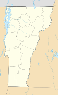
Stark Mountain is a cool mountain in the Green Mountains of Vermont, a state in the United States. People also call it General Stark Mountain. It's located in a town called Fayston, which is in Washington County. The very top of the mountain is about 3,662 feet (1,116 meters) high!
Stark Mountain got its name from a brave soldier named General John Stark. He was a hero in a big battle called the Battle of Bennington, which happened way back in 1777.
Contents
Water Flow: Where Rain Goes
Stark Mountain is part of the area that drains into Lake Champlain. Imagine all the rain and snow that falls on the mountain. This water flows into streams and rivers.
How Water Reaches Lake Champlain
The water from Stark Mountain eventually makes its way to Lake Champlain. From there, it flows into the Richelieu River in Québec, Canada. Then, it joins the mighty Saint Lawrence River and finally reaches the Gulf of Saint Lawrence in the ocean.
Rivers Around Stark Mountain
On the east side of Stark Mountain, water flows into Mill Brook. This brook then joins the Mad River, which flows into the Winooski River. Finally, the Winooski River empties into Lake Champlain.
On the west side of the mountain, water flows into the Huntington River. This river also connects to the Winooski River, and then into Lake Champlain. So, all the water from Stark Mountain ends up in the same big lake!
Hiking and Skiing Adventures
Stark Mountain is a great place for outdoor activities like hiking and skiing.
Exploring the Long Trail
The famous Long Trail goes right over the top of Stark Mountain. This trail is about 2.2 miles (3.5 kilometers) north of another mountain called Mount Ellen.
The easiest way to get onto this part of the Long Trail is by using the Jerusalem Trail. This trail is in Starksboro, Vermont, and it's also named after General John Stark!
Stark's Nest: A Mountain Hut
Just east of the Camel's Hump State Forest in Starksboro, you'll find a special place called Stark's Nest. It's located on the north peak of Stark Mountain, which is about 3,644 feet (1,111 meters) high.
In the winter, Stark's Nest is a warm hut for skiers at the Mad River Glen ski area. It's a perfect spot to take a break from the cold. In the summer, this hut becomes a lodge where hikers can stay overnight.
Hiking to Stark's Nest
You can hike to Stark's Nest from a place called Appalachian Gap using the Long Trail. This hike is about 2.5 miles (4 kilometers) long. You'll climb about 1,267 feet (386 meters) in height.
Another way to reach Stark's Nest is from the bottom of the Mad River Glen ski area. You take the Stark Mountain Trail, which is also about 2.5 miles (4 kilometers) long. This path is steeper, with a climb of about 2,036 feet (621 meters).
 | Valerie Thomas |
 | Frederick McKinley Jones |
 | George Edward Alcorn Jr. |
 | Thomas Mensah |


