Mount Ellen (Vermont) facts for kids
Quick facts for kids Mount Ellen |
|
|---|---|

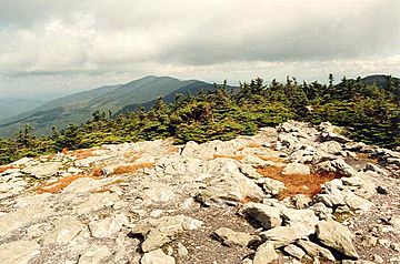
Mount Ellen seen from Mount Abraham
|
|
| Highest point | |
| Elevation | 4,083 ft (1,244 m) |
| Prominence | 2,132 ft (650 m) |
| Listing | |
| Geography | |
| Country | United States |
| State | Vermont |
| County | Washington |
| Town | Warren |
| Parent range | Green Mountains |
| Topo map | USGS Mount Ellen 1:24,000 |
Mount Ellen is a tall mountain located in the Green Mountains of Vermont, a state in the United States. It sits on the northern edge of the Green Mountain National Forest.
The top of Mount Ellen is in the town of Warren. However, parts of the mountain also reach into the nearby towns of Fayston and Lincoln. Mount Ellen is connected to Lincoln Peak to its south. Together, these mountains are home to the popular Sugarbush Resort, a place where people go to ski.
Mount Ellen is one of the few mountains in Vermont that is over 4,000 feet (about 1,219 meters) high. At 4,083 feet (1,244 meters), it is tied with Camel's Hump as the third-highest mountain in Vermont.
Contents
Exploring Mount Ellen's History
Have you ever wondered how a mountain gets its name? For Mount Ellen, the exact reason for its name is a bit of a mystery!
Theories Behind the Name
There are two main ideas about how Mount Ellen got its name:
- One idea is that Joseph Battell named it. He was a writer and nature-lover from Vermont. He might have named the mountain after a character named Ellen from his book, "Ellen, or the Whisperings of an Old Pine," which was published in 1903.
- Another idea suggests the mountain was named after Ellen Douglas. She was a main character in a famous poem called The Lady of the Lake, written by Sir Walter Scott in 1810.
Water Flowing from Mount Ellen
Mountains play a big role in how water moves across the land. Mount Ellen is part of a large area where all the rain and melting snow eventually flow into Lake Champlain. This whole area is called a watershed.
How Water Reaches Lake Champlain
Water from Mount Ellen takes different paths to reach Lake Champlain:
- On the eastern side of the mountain, water flows into a stream called Mill Brook. Mill Brook then joins the Mad River, which flows into the Winooski River. Finally, the Winooski River empties into Lake Champlain.
- On the western side of the mountain, water flows into the New Haven River. This river then joins Otter Creek, which also flows into Lake Champlain.
From Lake Champlain, the water continues its journey north into the Richelieu River in Quebec, Canada. The Richelieu River then flows into the Saint Lawrence River, and eventually, all this water reaches the Gulf of Saint Lawrence and the Atlantic Ocean.
Hiking Adventures on Mount Ellen
Mount Ellen is a great place for hiking! A famous long-distance trail, the Long Trail, goes right over the top of Mount Ellen. This trail runs between two mountain passes: Lincoln Gap and Appalachian Gap.
Finding Your Way on the Trails
The closest side trail to Mount Ellen's summit is called the Jerusalem Trail.
- You can start hiking the Jerusalem Trail in Starksboro, Vermont.
- After hiking about 2.4 miles (3.9 km), the Jerusalem Trail meets the Long Trail.
- From this meeting point, if you walk south on the Long Trail for about 1.8 miles (2.9 km), you will reach the summit of Mount Ellen.
- If you walk east from the intersection, you'll find the Glen Ellen Shelter about 0.4 miles (0.6 km away).
- Walking north for about 1.0 mile (1.6 km) will take you to Stark's Nest.
Skiing Fun at Mount Ellen
During the winter, parts of Mount Ellen become a snowy playground for skiers and snowboarders!
Sugarbush Resort
The eastern side of Mount Ellen is home to some of the ski trails for Sugarbush Resort. This resort offers many slopes for people to enjoy winter sports.
 | Ernest Everett Just |
 | Mary Jackson |
 | Emmett Chappelle |
 | Marie Maynard Daly |


