State Line Avenue facts for kids

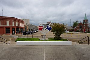
State Line Avenue is a special road in Texarkana, United States. It runs north and south for about 11 miles (18 km) right along the border between Texas and Arkansas. This unique street actually divides the city of Texarkana into two parts, one in each state!
Even though it's called "State Line Avenue," the exact middle of the road isn't always the state line. Instead, the lanes of traffic going south are in Texarkana, Texas (in Bowie County, Texas), and the lanes going north are in Texarkana, Arkansas (in Miller County, Arkansas). Imagine driving on a road where one side is in Texas and the other is in Arkansas! This road isn't one long, continuous street; it has two main parts that are separated by a gap of about one mile (1.6 km) near the downtown area.
Contents
Exploring State Line Avenue
Where the Road Begins and Ends
State Line Avenue starts at Broad Street. For many years, until 1980, it used to end at the old Texarkana Union Station, which was a train station. Near the western part of downtown, there's a special bridge called the "Texas Viaduct." This bridge carries cars over a busy rail yard to connect to the southern part of State Line Avenue.
The Two-State Building
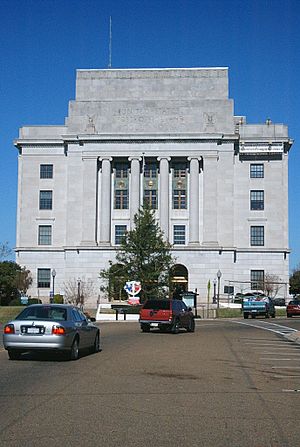
As you travel north through downtown Texarkana, State Line Avenue does something really interesting. The street actually splits around a central area, and in the middle of this split is the city's U.S. Post Office and Federal Building. This building is famous because it's the only one of its kind in the United States that is physically located in two different states at the same time! One part of the building is in Texas, and the other is in Arkansas.
Just one block north of this unique building, State Line Avenue crosses several major highways: US 67, US 71, and US 82. From there, US 71 joins State Line Avenue and continues heading north.
Shopping and Travel Along the Line
Further north, State Line Avenue continues to carry US 71. This part of the road is lined with many stores and shops. After about 3 miles (4.8 km), State Line Avenue meets I-30. This intersection is a busy spot with many hotels, showing how important this area is for travelers. At this interchange, US 59 also joins State Line Avenue, traveling north with US 71.
State Line Avenue continues its journey north, carrying both US 59 and US 71, until it reaches the bridge over the Red River.
Major Roads You'll Find
This table shows some of the important roads that cross or meet State Line Avenue in both Texas and Arkansas.
| Texas | Arkansas | |||||
|---|---|---|---|---|---|---|
| ← Denison | Red River | Fulton → | ||||
| ← Northridge Country Club | Lakeridge Dr. | Sugar Hill Road | AR 296 → | |||
| ← Aledo | Interstate 30 | North Little Rock → | ||||
| ← Laredo | ||||||
| ← Loop 14 | Texas Blvd | Arkansas Blvd | Texarkana Regional Airport → | |||
| ← Presidio | Dr. Martin Luther King, Jr. Blvd/ East 7th Street |
Sabula → | ||||
| ← Alamogordo | Krotz Springs → | |||||
| Brunswick → | ||||||
| ← Loop 151 to US 59 | The Loop | I-49 → | ||||
 | Sharif Bey |
 | Hale Woodruff |
 | Richmond Barthé |
 | Purvis Young |


