
Stepney, Kingston upon Hull facts for kids
Quick facts for kids Stepney |
|
|---|---|
 Stepney Lane, Stepney |
|
| OS grid reference | TA088304 |
| Unitary authority | |
| Ceremonial county | |
| Region | |
| Country | England |
| Sovereign state | United Kingdom |
| Post town | HULL |
| Postcode district | HU5 |
| Dialling code | 01482 |
| EU Parliament | Yorkshire and the Humber |
| UK Parliament |
|
Stepney is a part of Kingston upon Hull, a city in England. It's located north of the city centre, along the main road that goes from Hull to Beverley (the A1079). A long time ago, before the mid-1800s, Stepney was just a small village outside the main city area of Hull.
Contents
Exploring Stepney's Location
Today, Stepney is a busy part of the city of Hull. The main road from Hull to Beverley (the A1079) goes right through it. Stepney is mostly found around where this main road meets Stepney Lane.
To the west of Stepney, you'll find Pearson Park, a nice green space. The area's rough borders are Queens Road and Sculcoates Lane to the north. To the east is the Beverley and Barmston Drain, a large water channel, and beyond that is Wincolmlee. To the south, Stepney connects to more city areas along Beverley Road, which leads to the city centre.
Stepney is mainly a residential area, meaning lots of houses. You'll also find shops and services along the main road, plus some smaller businesses. The original village street from before the 1850s is still there. You can spot it by a slight bend in Beverley Road and a section of older, two-story houses.
Stepney's Journey Through Time
Let's look at how Stepney has changed over the years.
Early Roads and Waterways
After Hull was founded by Edward I in 1293, people started building permanent roads to nearby towns. One of these roads went to Beverley. In 1302, a group decided on the best paths for these roads. The road to Beverley later became a "turnpike" in 1744. This meant people had to pay a fee to use it, which helped pay for its upkeep.
The Beverley and Barmston Drain was approved in 1798. It was the biggest local drain, running north to south, about a third of a mile east of Stepney. A bridge on Stepney Lane, built around 1800, still crosses this drain today. There was also a smaller drain called Cottingham Drain. It was covered up in the late 1900s, and parts of it are now a path or have buildings on top.
The name "Stepney" likely comes from "Stepping Stone" or "Stepstone." This is because there used to be a mounting block nearby. A mounting block was a stone or set of steps used to help people get onto horses or into carriages.
Growth of a Hamlet
Around the late 1700s, a large house called Stepney Lodge was built. By 1817, more houses started appearing along Stepney Lane.

By the 1850s, Stepney had houses along the south side of Stepney Lane. There were also two pubs, the Bull Inn and the Rose Tavern, at the main crossroads. A paper mill called Stepney Mills was also here. Other houses like "Stepney House" and Stepney Lodge were further north.
Zion Chapel (also known as Stepney Chapel) was built in 1849. It was a simple, classical-style building with a smooth, stuccoed front. It was for the Methodist New Connexion church. James Rank, whose son Joseph Rank became famous for his flour mills, had a mill in Stepney in the mid-1800s. These mills first used wind power. In the 1850s and 60s, Stepney was still very much a farming area. There were vineyards at Stepney Lodge and a large plant nursery growing many different types of plants.
Expanding City Life
From the 1850s onwards, Stepney grew a lot. The Victoria Dock Branch Line, a railway line, opened in 1853. It went around Hull, passing through Stepney about 600 feet south of Stepney Lane. A train station, Stepney station, opened at the same time.
Pearson Park opened in 1862, giving people a new place to relax. In 1869, the 1849 Methodist chapel was replaced by a larger, Gothic-style building made of red and white bricks. This building was later taken down around 1982. Many large buildings were constructed along Beverley Road and the road to Pearson Park in the 1860s and 70s, including Dorchester House.
By the 1890s, the city had grown so much that it included Stepney and even stretched further north. The Hull and Barnsley Railway (built in 1885) now ran along the east side, next to the Barmston Drain. Most of Stepney was now built up with houses, except for the grounds of Stepney Lodge and some allotments (small plots of land for growing food). There was also a small goods yard at Stepney station and railway sidings near Sculcoates Goods station. The houses on the smaller streets off the main road were generally smaller than the big houses on Beverley Road.

In 1886 and 1887, the Hull School Board opened a new school in Stepney. It cost £11,470 to build and was designed in the Queen Anne Revival style. The school had a main two-story block with an attic and a bell tower for ventilation. Boys were on the ground floor, girls on the first, and younger children in a separate area. This new school could hold 889 children and replaced some older schools. In 1908, the school was made bigger with a separate building for the younger children.
Modern Developments and Changes
The Hull Street Tramways started a horse-drawn tram route on Beverley Road in 1875. In the 1890s, the city council took over the company and decided to make the tram route electric. A tram depot was opened south of Stepney Lane in 1898.
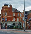
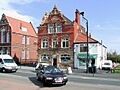
South of the railway line on Beverley Road, the Northern Library opened in 1895. It was built in a Gothic brick style. A branch of the Hull Savings Bank opened in 1901, across Beverley Road from the railway station. The 'Bull Inn' pub was rebuilt around 1903, and the Rose Tavern was also rebuilt around the same time.
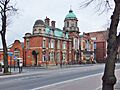
Beverley Road Baths opened in 1905, next to the Stepney school. It had an Edwardian Baroque design with a copper dome and a beautiful Art Nouveau tiled entrance. The baths were renovated from June 2020 to August 2021 and are now a Grade II Listed building, meaning they are historically important. The land where Stepney Lodge once stood was built over with new houses between the 1890s and 1920s.
Around the early 1900s, a bottling factory was built on the north side of Park Lane. This factory was later taken down in the late 1900s. The coal sidings and timber yard south of Stepney station became a saw mill by 1910. By the 1920s, it had turned into a billiard hall and a cinema called The Coliseum, which opened in 1912. Another saw mill, which later became a furniture factory, developed further west.
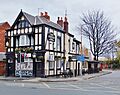
Stepney station closed in 1964, and the Victoria Dock Branch Line closed in 1969. The old railway track at Stepney was later turned into a path for walking and cycling. The former "Coliseum" cinema (which was later called the Rialto and then The National) closed in 1961 and became a bowling alley. Sadly, it burned down in 1974. In 1966, the paper company A. Mayfield and Sons, located at Stepney Mills, stopped doing business.
In 1976, a company called General Accident built office buildings on Beverley Road. The site of the "Coliseum" cinema was redeveloped into an Aldi supermarket in the 1990s. A small industrial area called Temple Street Industrial Estate was built in the late 1980s and early 1990s. Around 1995, a housing development for Chinese people was built on Park Lane. The old "Temple Street goods yard" and "corporation yard" sites were turned into playing fields with a sports hall in the early 2000s. A building combining a medical centre, a supermarket, a car park, and a takeaway restaurant was built in 2002 on the site of the former "General Accident" building.
Stepney in Books and Culture
The poet Douglas Dunn wrote a book of poems in 1967 called Terry Street. This book is named after the street in Stepney where he lived in the late 1960s.
Images for kids
-
Beverley Road Baths, built 1905 (2013)
-
The Rose Hotel, built around 1900 (2008)
-
The Station Inn, formerly next to the Victoria Dock Branch Line (2013)
-
The Bull Inn, built 1903–4 (2009)
-
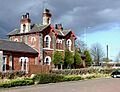
Stepney Railway station building (rear), built 1853 (2009)
-
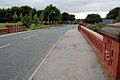
Bridge over the Beverley and Barmston Drain, on Sculcoates Lane, built 1889 (2008)
-
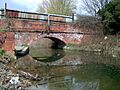
Bridge over the Beverley and Barmston Drain, on Stepney Lane (2009)
,_Hull.jpg)


