Steuben, New York facts for kids
Quick facts for kids
Steuben, New York
|
|
|---|---|

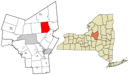
Location in Oneida County and the state of New York.
|
|
| Country | United States |
| State | New York |
| County | Oneida |
| Government | |
| • Type | Town Council |
| Area | |
| • Total | 42.70 sq mi (110.59 km2) |
| • Land | 42.65 sq mi (110.47 km2) |
| • Water | 0.05 sq mi (0.12 km2) |
| Elevation | 1,519 ft (463 m) |
| Population
(2010)
|
|
| • Total | 1,100 |
| • Estimate
(2016)
|
1,125 |
| • Density | 26.38/sq mi (10.18/km2) |
| Time zone | UTC-5 (Eastern (EST)) |
| • Summer (DST) | UTC-4 (EDT) |
| ZIP code |
13354
|
| Area code(s) | 315 |
| FIPS code | 36-71212 |
| GNIS feature ID | 0979525 |
Steuben is a small town located in Oneida County, New York, in the United States. In 2010, about 1,100 people lived there.
The town is named after Baron von Steuben. He was a general from Prussia who helped the American side during the American Revolutionary War. The Town of Steuben is about 18 miles (29 km) northwest of Utica.
Contents
A Look at Steuben's Past
Steuben is part of a special land gift given to Friedrich Wilhelm von Steuben. He received this land after the American Revolutionary War. He even had a summer home, a log cabin, right in the town. You can visit his burial site at a state historic spot east of Steuben village.
The town of Steuben was first created in 1792. It was formed from a part of the Town of Whitestown. Later, in 1796, some of Steuben's land was used to create two new towns: Floyd and Rome. Steuben became smaller again in 1797 when the Town of Western was formed from its land.
Where is Steuben?
According to the United States Census Bureau, the town covers an area of about 42.7 square miles (110.59 square kilometers). Almost all of this area is land.
Who Lives in Steuben?
| Historical population | |||
|---|---|---|---|
| Census | Pop. | %± | |
| 1800 | 552 | — | |
| 1810 | 1,105 | 100.2% | |
| 1820 | 1,461 | 32.2% | |
| 1830 | 2,091 | 43.1% | |
| 1840 | 1,993 | −4.7% | |
| 1850 | 1,754 | −12.0% | |
| 1860 | 1,554 | −11.4% | |
| 1870 | 1,264 | −18.7% | |
| 1880 | 1,223 | −3.2% | |
| 1890 | 1,005 | −17.8% | |
| 1900 | 902 | −10.2% | |
| 1910 | 785 | −13.0% | |
| 1920 | 786 | 0.1% | |
| 1930 | 690 | −12.2% | |
| 1940 | 581 | −15.8% | |
| 1950 | 540 | −7.1% | |
| 1960 | 586 | 8.5% | |
| 1970 | 735 | 25.4% | |
| 1980 | 897 | 22.0% | |
| 1990 | 1,006 | 12.2% | |
| 2000 | 1,172 | 16.5% | |
| 2010 | 1,100 | −6.1% | |
| 2016 (est.) | 1,125 | 2.3% | |
| U.S. Decennial Census | |||
In 2000, there were 1,172 people living in Steuben. The population density was about 27.4 people per square mile. This means there weren't too many people living close together.
About 27.3% of the people in Steuben were under 18 years old. The average age of people living in the town was 38 years.
Places in Steuben
Here are some of the communities and locations you can find in the town of Steuben:
- Boody Hill – A hill located northwest of the main Steuben area.
- Bowen Hill – Another hill, found north of Fink Hollow.
- East Steuben – A small community (hamlet) in the northeastern part of the town.
- Fink Hollow – A hamlet located north of the main Steuben area.
- Maple Mountain – A mountain located northwest of Steuben.
- Merrick Corner – A hamlet south of Steuben.
- Oakes Hill – A hill located northwest of Steuben.
- Penn Mountain – A mountain located west of East Steuben.
- Sixty Corners – A spot northeast of Steuben, close to the historic site.
- Steuben – This is the main village, sometimes called "Steuben Corners." It's on NY 274.
- Steuben Memorial State Historic Site – A special historic place near the eastern edge of the town.
- Steuben Valley – A hamlet at the southern border of the town, southeast of the main Steuben village.
See also
 In Spanish: Steuben (Nueva York) para niños

