
Stockton, New Jersey facts for kids
Quick facts for kids
Stockton, New Jersey
|
||
|---|---|---|
|
Borough
|
||

The Stockton Inn
|
||
|
||

Location of Stockton in Hunterdon County highlighted in red (left). Inset map: Location of Hunterdon County in New Jersey highlighted in orange (right).
|
||

Census Bureau map of Stockton, New Jersey
|
||

Stockton, New Jersey
Location in Hunterdon County, New Jersey

Stockton, New Jersey
Location in New Jersey

Stockton, New Jersey
Location in the United States
|
||
| Country | ||
| State | ||
| County | ||
| Incorporated | April 14, 1898 | |
| Government | ||
| • Type | Borough | |
| • Body | Borough Council | |
| Area | ||
| • Total | 0.62 sq mi (1.61 km2) | |
| • Land | 0.55 sq mi (1.41 km2) | |
| • Water | 0.07 sq mi (0.19 km2) 12.10% | |
| Area rank | 537th of 565 in state 26th of 26 in county |
|
| Elevation | 121 ft (37 m) | |
| Population
(2020)
|
||
| • Total | 495 | |
| • Estimate
(2023)
|
494 | |
| • Rank | 552nd of 565 in state 26th of 26 in county |
|
| • Density | 906.2/sq mi (349.9/km2) | |
| • Density rank | 394th of 565 in state 11th of 26 in county |
|
| Time zone | UTC−05:00 (Eastern (EST)) | |
| • Summer (DST) | UTC−04:00 (Eastern (EDT)) | |
| ZIP Code |
08559
|
|
| Area code(s) | 609 | |
| FIPS code | 3401970980 | |
| GNIS feature ID | 0885409 | |
| Website | ||

Stockton is a small town, called a borough, located in Hunterdon County, New Jersey. It sits right on the Delaware River, which forms the border with Pennsylvania. In 2020, about 495 people lived here.
Stockton became an official borough on April 14, 1898. It was formed from parts of Delaware Township.
Contents
History of Stockton
Stockton is found along the Delaware River, just north of Lambertville. This area was first known by different names. It was called Reading Ferry, and later Howell's Ferry.
How Stockton Got Its Name
The name changed to Centre Bridge Station to match a post office and small village on the Pennsylvania side of the river. In 1851, a railroad station and a local post office were built. At this time, the community was named Stockton. It was named after U.S. Senator Robert Field Stockton. He helped create the Delaware and Raritan Canal, which was very important for transportation.
Stockton quickly grew into a busy town. Mills and quarries (places where stone is dug) started up in the area. In 1852, the Belvidere Delaware Railroad arrived, which helped the town become even more successful. In 1898, Stockton officially became its own borough, separate from Delaware Township.
Historic Places to Visit
Stockton has some interesting old buildings. The Stockton Inn, also known as Colligan's Stockton Inn, was first built in 1710. Its Dog & Deer Tavern opened in 1796. This inn was even the inspiration for a famous song called "There's a Small Hotel" from a 1936 Broadway musical.
The Delaware River Mill Society works to protect and share the history of the Prallsville Mills. John Prall Jr. owned this site in 1794, and the area became known as Prallsville.
The Delaware River Mill Society is a group that restores and takes care of the historic John Prall Jr. House and the Prallsville Mills Complex. This site was added to the National Register of Historic Places in 1973. It became part of the D & R Canal State Park in the same year. When New Jersey couldn't pay for the restoration in 1976, local people formed the society to save the site.
Today, Prallsville Mills hosts many cultural and environmental events. Visitors can explore 10 historic buildings. These include an 1877 grist mill (for grinding grain), a 1790 linseed oil mill, an 1850 saw mill, and a 1900 grain silo. Concerts, art shows, and other events help raise money to keep the site running. Artist Ty Hodanish has his studio and gallery, called The Art Colony, in the Linseed Mill. The Mill is also part of the Delaware River Scenic Byway.
Where is Stockton Located?
Stockton covers a total area of about 0.62 square miles (1.61 square kilometers). Most of this is land, with a small part being water.
The borough shares its borders with Delaware Township in Hunterdon County. It also borders Solebury Township in Bucks County, Pennsylvania, across the river. Prallsville is a small community right on the border with Delaware Township.
Who Lives in Stockton?
| Historical population | |||
|---|---|---|---|
| Census | Pop. | %± | |
| 1900 | 590 | — | |
| 1910 | 605 | 2.5% | |
| 1920 | 519 | −14.2% | |
| 1930 | 556 | 7.1% | |
| 1940 | 478 | −14.0% | |
| 1950 | 488 | 2.1% | |
| 1960 | 520 | 6.6% | |
| 1970 | 619 | 19.0% | |
| 1980 | 643 | 3.9% | |
| 1990 | 629 | −2.2% | |
| 2000 | 560 | −11.0% | |
| 2010 | 538 | −3.9% | |
| 2020 | 495 | −8.0% | |
| 2023 (est.) | 494 | −8.2% | |
| Population sources: 1900–1920 1900–1910 1910–1930 1940–2000 2000 2010 2020 |
|||
The 2010 United States census counted 538 people living in Stockton. Most residents were White (98.33%). A small number were Asian (0.93%) or from two or more races (0.74%). About 0.56% of the population was Hispanic or Latino.
In 2010, about 19.5% of the people were under 18 years old. The average age in Stockton was 47.7 years.
Education in Stockton

Stockton is part of the South Hunterdon Regional School District. This district serves students from Lambertville, Stockton, and West Amwell Township. Students from pre-kindergarten through twelfth grade attend schools in this district.
As of the 2022–23 school year, the district had 827 students and 108 teachers. This means there were about 7.7 students for every teacher. The schools in the district are:
- South Hunterdon Regional Elementary School (PreK–4)
- South Hunterdon Regional Middle School (5–8)
- South Hunterdon Regional High School (9–12)
Stockton has one of the nine seats on the regional school district's board of education.
Changes to Stockton's School System
Historically, Stockton had its own school district for students in grades K–6. The only school building, the District No. 98 Schoolhouse, had been used since 1872.
In 2013, voters from Lambertville, Stockton, and West Amwell Township decided to combine their school districts. This created one large regional district for all students from Pre-K to 12th grade. The Stockton school building closed after the 2017–2018 school year. Now, elementary students from Stockton go to schools in Lambertville and West Amwell.
Students in eighth grade from all of Hunterdon County can apply to special high school programs. These are offered by the Hunterdon County Vocational School District. This district provides career and technical education at its campuses.
Getting Around Stockton
_at_Hunterdon_County_Route_523_(Stockton-Flemington_Road)_in_Stockton,_Hunterdon_County,_New_Jersey.jpg)
As of 2010, Stockton had about 4.09 miles of roads. The town itself takes care of 2.50 miles of these roads.
The main roads that go through Stockton are Route 29 and County Route 523.
The Centre Bridge-Stockton Bridge
The Centre Bridge-Stockton Bridge connects Stockton, New Jersey, to Solebury Township, Pennsylvania. It stretches 825 feet over the Delaware River. This bridge does not charge a toll to cross.
The first bridge at this spot opened in 1814. It was a covered bridge, but it was destroyed in a flood in 1841. This flood caused a lot of damage to many bridges along the Delaware River.
Famous People from Stockton
Many interesting people have lived in or are connected to Stockton:
- Anne Elstner (1899–1981) – An actress famous for her role in the radio show Stella Dallas.
- Chet Huntley (1911–1974) – A well-known television newscaster who co-anchored the Huntley-Brinkley Report for NBC.
- JP Miller (1919–2001) – A writer who wrote many teleplays during the early days of television.
- Lansing Pilch – A retired United States Air Force major general.
- Carolyn Rovee-Collier (1942–2014) – A leading expert in how children's minds develop.
Images for kids
-
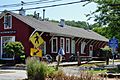
Former station for the Belvidere Delaware Railroad


See also
 In Spanish: Stockton (Nueva Jersey) para niños
