
Strahan, Tasmania facts for kids
Quick facts for kids StrahanTasmania |
|||||||||
|---|---|---|---|---|---|---|---|---|---|

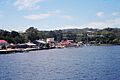
A view of Strahan, taken from a boat in Macquarie Harbour
|
|||||||||

Strahan
Location in Tasmania
|
|||||||||
| Population | 634 (2021 census) | ||||||||
| Postcode(s) | 7468 | ||||||||
| Elevation | 20 m (66 ft) | ||||||||
| Location |
|
||||||||
| LGA(s) | West Coast Council | ||||||||
| State electorate(s) | Braddon | ||||||||
| Federal Division(s) | Braddon | ||||||||
|
|||||||||
Strahan (pronounced STRAWN) is a small town on the west coast of Tasmania. It used to be a busy port, but now it's a popular spot for tourists. Strahan is located on Macquarie Harbour. In 2021, about 634 people lived there.
Strahan Harbour and Risby Cove are part of the northern end of Macquarie Harbour. This area is known for its beautiful views and connection to the wilderness.
Contents
Strahan's History as a Port
Strahan first grew as a port for mining towns nearby. It was first called Long Bay or Regatta Point. In 1881, the town was renamed after the new Governor, Sir George Cumine Strahan. It officially became a town in 1892.
Strahan was very important for the timber industry. Many trees, especially Huon Pine, were cut down around Macquarie Harbour. These trees were then shipped out from Strahan. For many years, ships also carried people and goods from this port.
Fishing and Tourism in Strahan

Strahan has always been home to a small fishing fleet. These brave fishers sail out into the tough conditions of the west coast and through a narrow entrance called Hell's Gates. Strahan is also the closest town to Cape Sorell.
It is often called the 'gateway' to the wild south-west of Tasmania. Boats, planes, and helicopters use Strahan as their starting point for trips into this amazing wilderness.
Exploring the Wild Rivers
The Huon Pine industry used to harvest trees from around the harbour. They also got timber from rivers like the King River, the Franklin River, and the Gordon River.
Strahan is where you can find the only airport in Western Tasmania that can be used in all weather. It also has an important weather station.
Many boat trips start from Strahan. You can visit Sarah Island, which was once a very harsh prison settlement. You can also take a boat trip down the lower Gordon River.
Strahan is a main entry point to the Franklin-Gordon Wild Rivers National Park. This park became part of the Tasmanian Wilderness World Heritage Area in 1982. For several years, Strahan was a key place for people who wanted to protect the Franklin River from a proposed dam.
Local Entertainment
Strahan is home to the Round Earth Theatre Company. This group offers tours of Sarah Island. They also perform a daily play called The Ship That Never Was. This play is about Sarah Island and has been performed over 5,000 times, making it Australia's longest-running play!
Strahan's Railway Connections
Strahan was a stop on the old Strahan to Zeehan railway. This stop was also known as Strahan Wharf. The railway was owned by the government. It ran past the wharf and then south around the harbour before heading north to Zeehan.
Strahan was also connected to the old Mount Lyell railway line at a station called Regatta Point. Today, Regatta Point is the start of the West Coast Wilderness Railway, which is still running.
Strahan's Weather
Strahan has an oceanic climate. This means it has cool, wet summers and cool to cold, very rainy winters. Because it's on Tasmania's West Coast, Strahan often gets strong winds and heavy rain from storms coming from the Southern Ocean. On average, Strahan has about 15.7 clear days each year.
Temperatures don't change much between summer and winter. Even in summer, temperatures can drop below 3°C (37°F). Very hot weather is rare. A temperature of 35°C (95°F) or higher happens only about once every three years. The highest temperature ever recorded was 38.6°C (101.5°F) in February 1982. The lowest was -3.0°C (26.6°F) in June 1983. Snow rarely falls at sea level, but it often snows in the low hills just a few kilometers inland from Strahan.
| Climate data for Strahan Aerodrome | |||||||||||||
|---|---|---|---|---|---|---|---|---|---|---|---|---|---|
| Month | Jan | Feb | Mar | Apr | May | Jun | Jul | Aug | Sep | Oct | Nov | Dec | Year |
| Record high °C (°F) | 38.0 (100.4) |
38.6 (101.5) |
36.1 (97.0) |
27.8 (82.0) |
22.5 (72.5) |
19.9 (67.8) |
18.3 (64.9) |
22.1 (71.8) |
27.0 (80.6) |
31.9 (89.4) |
32.9 (91.2) |
36.7 (98.1) |
38.6 (101.5) |
| Mean daily maximum °C (°F) | 20.8 (69.4) |
21.3 (70.3) |
19.5 (67.1) |
16.8 (62.2) |
14.3 (57.7) |
12.6 (54.7) |
12.2 (54.0) |
13.1 (55.6) |
14.4 (57.9) |
16.1 (61.0) |
17.9 (64.2) |
19.8 (67.6) |
16.6 (61.9) |
| Mean daily minimum °C (°F) | 10.7 (51.3) |
10.8 (51.4) |
9.8 (49.6) |
8.4 (47.1) |
7.4 (45.3) |
5.5 (41.9) |
5.2 (41.4) |
5.7 (42.3) |
6.3 (43.3) |
7.3 (45.1) |
8.3 (46.9) |
9.7 (49.5) |
7.9 (46.2) |
| Record low °C (°F) | 0.6 (33.1) |
2.6 (36.7) |
0.8 (33.4) |
−0.2 (31.6) |
−0.4 (31.3) |
−3.0 (26.6) |
−2.7 (27.1) |
−2.5 (27.5) |
−2.4 (27.7) |
−1.1 (30.0) |
0.9 (33.6) |
1.1 (34.0) |
−3.0 (26.6) |
| Average precipitation mm (inches) | 82.5 (3.25) |
68.8 (2.71) |
105.7 (4.16) |
114.0 (4.49) |
158.5 (6.24) |
155.3 (6.11) |
181.6 (7.15) |
181.1 (7.13) |
151.5 (5.96) |
119.3 (4.70) |
94.0 (3.70) |
94.6 (3.72) |
1,552.2 (61.11) |
| Average precipitation days | 15.9 | 12.9 | 18.1 | 19.4 | 23.2 | 21.7 | 23.5 | 25.0 | 23.1 | 21.9 | 18.5 | 18.2 | 241.4 |
| Average afternoon relative humidity (%) | 62 | 60 | 64 | 69 | 75 | 76 | 75 | 71 | 69 | 64 | 61 | 63 | 67 |
| Source: Bureau of Meteorology | |||||||||||||
Images for kids
-
A view of Strahan, taken from a boat in Macquarie Harbour
-
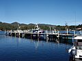
Strahan port and fishing vessels
See also
 In Spanish: Strahan para niños
