
Straits of Mackinac Shipwreck Preserve facts for kids
Quick facts for kids Straits of Mackinac Shipwreck Preserve |
|
|---|---|

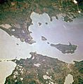
Aerial view of the waters protected within the Straits of Mackinac Shipwreck Preserve.
|
|

Straits of Mackinac Shipwreck Preserve
Location in Michigan
|
|
| Location | Lake Huron, Lake Michigan, Cheboygan County, Emmet County, Mackinac County, Michigan, USA |
| Nearest city | Mackinaw City, Michigan |
| Area | 148 square miles (380 km2) |
| Governing body | Michigan Department of Natural Resources |
The Straits of Mackinac Shipwreck Preserve is a special underwater area in Michigan. It covers about 148 square miles (383 square kilometers) in and around the Straits of Mackinac. This preserve is like an underwater museum. It protects many old shipwrecks and interesting natural spots.
The preserve is split into two parts by the famous Mackinac Bridge. It includes waters near towns like Mackinaw City and St. Ignace. It also covers parts of the shorelines of several islands. These islands are Bois Blanc Island, Mackinac Island, Round Island, and St. Helena Island.
Sunken Ships of the Straits
The waters of the Straits of Mackinac have seen many ships sink over the years. This area often had thick fog, making it hard for ships to see. Also, many ships traveled through these busy waters. Before radar was invented in the 1940s, it was even more dangerous.
To help guide ships, many lighthouses were built around the preserve. Even with these lights, accidents still happened. One more recent shipwreck in the preserve is the Cedarville. This large ship was carrying limestone when it sank in 1965 after hitting another vessel.
Underwater Wonders
Besides shipwrecks, the preserve also has cool natural features underwater. Divers can explore rock formations made of Mackinac breccia near Mackinac Island. One of these is called the "Rock Maze." It is located offshore from Arch Rock.
Further east from Arch Rock, explorers found something amazing in 2007. They discovered a drowned waterfall formation. This underwater waterfall, called Mackinac Falls, is about 100 feet (30 meters) tall!
Images for kids
-
Aerial view of the waters protected within the Straits of Mackinac Shipwreck Preserve.
