
Stuart, Virginia facts for kids
Quick facts for kids
Stuart, Virginia
|
|
|---|---|

Historic Patrick County Courthouse
|
|

Location of Stuart, Virginia
|
|
| Country | United States |
| State | Virginia |
| County | Patrick |
| Founded | 1792 |
| Government | |
| • Type | Mayor-Council |
| Area | |
| • Total | 3.04 sq mi (7.87 km2) |
| • Land | 3.04 sq mi (7.87 km2) |
| • Water | 0.00 sq mi (0.00 km2) |
| Elevation | 1,345 ft (410 m) |
| Population
(2010)
|
|
| • Total | 1,408 |
| • Estimate
(2019)
|
1,271 |
| • Density | 418.37/sq mi (161.53/km2) |
| Time zone | UTC−5 (Eastern (EST)) |
| • Summer (DST) | UTC−4 (EDT) |
| ZIP code |
24171
|
| Area code(s) | 276 |
| FIPS code | 51-76256 |
| GNIS feature ID | 1500182 |
Stuart is a town in Patrick County, Virginia, United States. It is the main town, also known as the county seat, for Patrick County. In 2010, about 1,408 people lived there. The town of Stuart got its name from Confederate General J.E.B. Stuart, who was born nearby in Ararat, Virginia.
Contents
History of Stuart, Virginia
Stuart has a long and interesting history, starting way back in the 1700s. It began as a small settlement and grew into the town it is today.
How Stuart Began: From Taylorsville to a Town (1792–1860)
The town of Stuart was first named Taylorsville, Virginia, in 1792. It was named after an early settler, George Taylor. Stuart has been the main town of Patrick County since 1791. This was when the county was first created from part of Henry County, Virginia.
Captain Eliphaz Shelton, who was part of the Patrick County Revolutionary War Militia, gave the land for the new courthouse and town. The Patrick County Courthouse was built right in the middle of the town. The area around the courthouse, called the Stuart Uptown Historic District, still has many old government, bank, church, and business buildings from the mid-1800s to mid-1900s.
By 1850, Taylorsville had grown quite a bit. It had about 50 homes and businesses. The 1850 census showed 18 families with 50 adults and 60 children living near the courthouse. People worked as farmers, innkeepers, merchants, lawyers, doctors, and more. The Danville and Wytheville Turnpike, which is now part of U.S. Route 58, was built in the 1850s. This road helped people travel and trade.
Growth and Change: Railroads and New Names (1860–1916)
After the American Civil War, people in Taylorsville wanted to make the economy stronger. They focused on building railroads to connect to bigger markets. The Danville and New River Railroad was started in 1873. The train line reached Martinsville, Virginia by 1881. In 1883, people in Patrick County agreed to spend $150,000 to make the line longer. The first train arrived in Taylorsville in August 1884.
Because of the railroad, Taylorsville grew a lot. In 1884, it officially became a town and was renamed Stuart. This was to honor Confederate Major General J.E.B. Stuart, who was born about 20 miles west of town.
After the railroad was finished, Stuart kept growing. The population went up by 25% from 300 people in 1884 to 371 in 1900. More people worked for the railroad, as salesmen, or in other new jobs. The railroad also created two different parts of town: "uptown" and "downtown." The original courthouse area was "uptown" on a hill. A new area with factories and shops grew "downtown" next to the railroad, along the Mayo River. Both areas were important and worked together. The town's first telephone line connected the downtown train station to the uptown Hotel Perkins.
Modern Times: New Services and Roads (1917–1945)
Before 1915, Stuart did not have public water or sewer systems. People got their water from private wells or nearby springs. There were no streetlights, and people used oil lamps inside their homes. Roads were not paved, and sidewalks were made of wood. After the water system was put in, people liked it a lot. By 1926, the town had grown so much that more improvements were needed.
In 1916, the Clark Power and Light Company brought the first electric light system to Stuart. Customers paid a small fee each month. If enough people signed up, the lights would stay on all night. Later, other companies took over, and in 1938, Appalachian Electric Power Company bought them out.
The first telegraph came to Stuart when the railroad was finished in 1884. The first telephone was reportedly at the Hotel Perkins. By 1923, ten phone lines served the county. In 1937, the Lee Telephone Company bought all the private lines. Today, Centurylink provides phone service to Patrick County.
Traveling to Stuart was hard until the first paved road from Martinsville reached the town in 1925. More roads were paved in the following years, connecting Stuart to North Carolina and Hillsville, Virginia. Today, State Routes 8 and U.S. Route 58 serve the town and county. Route 58 is a big, four-lane highway that goes across the entire state of Virginia.
By 1940, Stuart's population had grown to 600 people. Many of the buildings you see today were built by then. The Patrick County Bank, for example, built its large Classical building across from the courthouse in 1911. The two main churches, Stuart United Methodist Church and Stuart Baptist Church, also built their current buildings in the early 1900s.
Stuart Today
Stuart is a town that welcomes everyone. It has a growing downtown area and new shops along the Highway 58 road. Some new additions include a walking trail along the Mayo River, a new Farmer's Market in the town center, and improved sidewalks on Main Street.
Important historical places like the Stuart Uptown Historic District, Goblintown Mill, and Patrick County Courthouse are listed on the National Register of Historic Places. This means they are recognized as special places that should be protected.
Geography of Stuart
Stuart is located at 36°38′25″N 80°16′26″W / 36.64028°N 80.27389°W. The town covers about 0.7 square miles (1.9 km2) of land.
Stuart is a hilly town located in a small valley. It is surrounded by the beautiful Blue Ridge Mountains. The Mayo River flows right through the middle of the town and continues through Patrick County.
Climate in Stuart
Stuart has a climate with warm summers and mild winters. The hottest month is usually July, and the coldest is January. It gets a good amount of rain throughout the year. Snowfall is usually light, with most of it falling in January and February.
| Climate data for Stuart, Virginia (1991–2020 normals, extremes 1913–present) | |||||||||||||
|---|---|---|---|---|---|---|---|---|---|---|---|---|---|
| Month | Jan | Feb | Mar | Apr | May | Jun | Jul | Aug | Sep | Oct | Nov | Dec | Year |
| Record high °F (°C) | 79 (26) |
82 (28) |
88 (31) |
95 (35) |
98 (37) |
101 (38) |
105 (41) |
102 (39) |
99 (37) |
95 (35) |
88 (31) |
86 (30) |
105 (41) |
| Mean daily maximum °F (°C) | 48.1 (8.9) |
51.9 (11.1) |
59.3 (15.2) |
69.6 (20.9) |
76.4 (24.7) |
82.8 (28.2) |
86.1 (30.1) |
84.6 (29.2) |
79.3 (26.3) |
70.6 (21.4) |
60.0 (15.6) |
51.2 (10.7) |
68.3 (20.2) |
| Daily mean °F (°C) | 36.7 (2.6) |
39.5 (4.2) |
46.2 (7.9) |
55.6 (13.1) |
63.9 (17.7) |
71.2 (21.8) |
74.8 (23.8) |
73.5 (23.1) |
67.8 (19.9) |
57.4 (14.1) |
46.9 (8.3) |
39.7 (4.3) |
56.1 (13.4) |
| Mean daily minimum °F (°C) | 25.2 (−3.8) |
27.2 (−2.7) |
33.1 (0.6) |
41.6 (5.3) |
51.3 (10.7) |
59.5 (15.3) |
63.5 (17.5) |
62.3 (16.8) |
56.3 (13.5) |
44.2 (6.8) |
33.8 (1.0) |
28.3 (−2.1) |
43.9 (6.6) |
| Record low °F (°C) | −17 (−27) |
−5 (−21) |
2 (−17) |
15 (−9) |
29 (−2) |
31 (−1) |
46 (8) |
44 (7) |
33 (1) |
21 (−6) |
7 (−14) |
−3 (−19) |
−17 (−27) |
| Average precipitation inches (mm) | 4.13 (105) |
3.15 (80) |
4.04 (103) |
4.18 (106) |
5.00 (127) |
5.25 (133) |
5.36 (136) |
5.18 (132) |
5.05 (128) |
3.50 (89) |
3.36 (85) |
4.08 (104) |
52.28 (1,328) |
| Average snowfall inches (cm) | 2.0 (5.1) |
2.1 (5.3) |
0.5 (1.3) |
0.1 (0.25) |
0.0 (0.0) |
0.0 (0.0) |
0.0 (0.0) |
0.0 (0.0) |
0.0 (0.0) |
0.0 (0.0) |
0.0 (0.0) |
1.7 (4.3) |
6.4 (16) |
| Average precipitation days (≥ 0.01 in) | 9.6 | 8.6 | 9.8 | 10.4 | 12.4 | 12.5 | 13.2 | 12.1 | 10.1 | 8.9 | 8.3 | 10.0 | 125.9 |
| Average snowy days (≥ 0.1 in) | 1.0 | 1.1 | 0.4 | 0.1 | 0.0 | 0.0 | 0.0 | 0.0 | 0.0 | 0.0 | 0.0 | 0.5 | 3.1 |
| Source: NOAA | |||||||||||||
People of Stuart: Demographics
| Historical population | |||
|---|---|---|---|
| Census | Pop. | %± | |
| 1890 | 332 | — | |
| 1900 | 371 | 11.7% | |
| 1910 | 388 | 4.6% | |
| 1920 | 401 | 3.4% | |
| 1930 | 588 | 46.6% | |
| 1940 | 720 | 22.4% | |
| 1950 | 849 | 17.9% | |
| 1960 | 974 | 14.7% | |
| 1970 | 947 | −2.8% | |
| 1980 | 1,131 | 19.4% | |
| 1990 | 965 | −14.7% | |
| 2000 | 961 | −0.4% | |
| 2010 | 1,408 | 46.5% | |
| 2019 (est.) | 1,271 | −9.7% | |
| U.S. Decennial Census | |||
In 2010, Stuart had 1,408 people living there. The town had 629 households and 315 families. This means there were about 1,301.5 people for every square mile. Most people (86.4%) were White, and 8.9% were African American. About 3.1% of the population was Hispanic or Latino.
There were 449 households in total. About 25.8% of these had children under 18 living with them. Many households (42.1%) were made up of single people. About 19.8% of households had someone aged 65 or older living alone. The average household had 2.09 people, and the average family had 2.85 people.
The population in Stuart was spread out by age. About 22.4% were under 18, and 19.8% were 65 or older. The average age in town was 40 years old.
Learning in Stuart: Education
The Patrick County Public School System has six elementary schools and one high school. Stuart Elementary School and Patrick County High School are both located within the town.
Stuart Elementary School teaches about 500 students each year, from pre-kindergarten to seventh grade. This school often ranks among the best in Virginia for its test scores and academic success.
Patrick County High School serves about 1,000 students in grades 8–12. It is a fully recognized school. The high school has won many awards in both academics and sports. For example, they have been champions in cross country, football, and women's basketball. U.S. News & World Report has even ranked Patrick County High School as one of the top public high schools in America.
Services for the Community
Stuart has important public services for its residents. It has the first hospital in Virginia to be called a "Critical Access Hospital." This means it provides important healthcare services to the community.
The town also offers public water and sewer services to people in the Stuart-Patrick Springs area. While Stuart does not have an airport, it has local media outlets. These include the 1270 AM WHEO Radio Station, Cable 5 TV, and The Enterprise, which is the town's weekly newspaper.
Fun in Stuart: Notable Events
Stuart hosts several fun events throughout the year.
- The Easter Brothers' Homecoming Gospel Sing is an annual festival held every July. It celebrates the Easter Brothers, a local music group that became famous.
- Stuart also has the oldest continuous beach music festival on the East Coast, called "Hot Fun in the Summertime."
- Other popular events include the Virginia Peach Festival, The Stuart Apple Dumpling and Strawberry Festivals, The Stuart Food and Wine Festival, The 4th of July Celebration, The Patrick County Fair, and various musical events on the Crooked Road Music Trail.
Famous People from Stuart
Many notable people have connections to Stuart, Virginia:
- Gerald Baliles: He was the 65th governor of Virginia.
- Martin Clark: An author and a judge for the Virginia Circuit Court.
- Brad Clontz: A professional baseball player.
- Beatrice Farnham: A talented artist.
- Turner Foddrell: A Piedmont blues and folk acoustic guitarist, singer, and songwriter.
- Chris Pritt: A member of the West Virginia House of Delegates.
- Mary Sue Terry: The first female attorney general of Virginia.
- Wood Brothers: A famous NASCAR racing team.
Images for kids
-
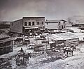
Stuart Train Depot, around 1895.
-
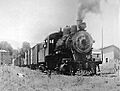
Engine, Danville and Western Railway, around 1900.
-
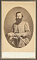
General J. E. B. Stuart, who the town of Stuart is named after.
-
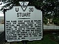
Virginia state historic marker in Stuart.
-
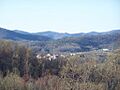
Stuart nestled within the Blue Ridge Mountains.
-
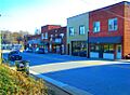
Historical Street in Downtown Stuart.


See also
 In Spanish: Stuart (Virginia) para niños
