Sunrise Mountain (Nevada) facts for kids
Quick facts for kids Sunrise Mountain |
|
|---|---|

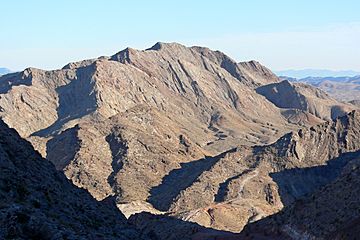
Sunrise Mountain seen from road/trail up Frenchman Mountain
|
|
| Highest point | |
| Elevation | 3,366 ft (1,026 m) NAVD 88 |
| Prominence | 924 ft (282 m) |
| Geography | |
| Location | Clark County, Nevada, U.S. |
| Topo map | USGS Frenchman Mountain |
Sunrise Mountain is a mountain located east of Las Vegas in Clark County, Nevada. It stands tall at about 3,366 feet (1,026 meters) above sea level.
Contents
Why is Sunrise Mountain Confusing?
Even though Sunrise Mountain has its own name, many people in the Las Vegas Valley often call a different, taller mountain "Sunrise Mountain." This other mountain is actually named Frenchman Mountain. The reason for this mix-up is simple: the sun appears to rise from behind Frenchman Mountain when viewed from Las Vegas.
The "Sunrise" Benchmark
This confusion has been around for many years. In 1947, the U.S. National Geodetic Survey placed a special marker, called a benchmark, on top of Frenchman Mountain. A benchmark is a permanent marker used by surveyors to mark a point with a known elevation. Interestingly, this benchmark was officially named "Sunrise," which added to the confusion between the two mountains.
Sunrise Mountain During World War II
During World War II, Sunrise Mountain played a small but important role. The United States Army used the summit of the mountain to maintain an airway beacon. An airway beacon is like a very bright light that helps airplanes find their way, especially at night or in bad weather.
Remains of the Beacon
Even as recently as 2007, you could still find parts of the old tower from this beacon on the mountain's summit. These remains are a small reminder of the mountain's history and its connection to air travel during the war.
 | Charles R. Drew |
 | Benjamin Banneker |
 | Jane C. Wright |
 | Roger Arliner Young |

