
Tägerig facts for kids
Quick facts for kids
Tägerig
|
||
|---|---|---|

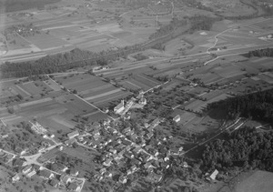
Tägerig village
|
||
|
||

Tägerig
Location in Switzerland

Tägerig
Location in Canton of Aargau
|
||
| Country | Switzerland | |
| Canton | Aargau | |
| District | Bremgarten | |
| Area | ||
| • Total | 3.29 km2 (1.27 sq mi) | |
| Elevation | 396 m (1,299 ft) | |
| Population
(Dec 2020 )
|
||
| • Total | 1,470 | |
| • Density | 446.8/km2 (1,157/sq mi) | |
| Postal code |
5522
|
|
| Surrounded by | Hägglingen, Mellingen, Niederwil, Stetten, Wohlenschwil | |


Tägerig is a small town, also called a municipality, located in the Bremgarten district in Switzerland. It's part of the canton of Aargau, which is like a state or region in Switzerland.
Contents
History of Tägerig
People lived in the Tägerig area a very long time ago, even before written records existed. We know this because shaped flint tools have been found north of the village.
The first time Tägerig was mentioned in official papers was in the 12th century. It was called Tegrank then, and later Tegeranc in 1189.
For a long time, Tägerig was part of a special area called Twingherrschaft. In the 14th century, this area was a fief (land given by a lord in exchange for loyalty) of the Habsburg family. They gave it to the Knights of Rüssegg. Over the years, it was passed to different noble families, including the Freiherren of Wohlen and Segesser of Brunegg. In 1543, the city of Mellingen took control.
Tägerig first belonged to the main church in Niederwil. Later, in 1669, a smaller chapel was built in Tägerig. After a big fire in 1838, a new church was built in 1846. In 1864, Tägerig got its own separate parish (church community).
In the 18th century, many people in Tägerig worked in farming and the straw plaiting industry (making things from woven straw). But as the straw industry became less important in the late 1800s and early 1900s, the number of people living in Tägerig went down. By the 1920s, most people traveled to nearby towns like Mellingen and Baden for work. Even today, many people who live in Tägerig commute to jobs elsewhere.
Geography of Tägerig

Tägerig covers an area of about 3.3 square kilometers (about 1.3 square miles). A large part of this land, about 43%, is used for farming. Forests cover about 39% of the area. The rest of the land, about 15.5%, has buildings or roads, and a small part (2.4%) is made up of rivers or other natural areas.
The municipality is located in the Reuss river valley. It includes the main village of Tägerig, which is on the flat valley floor, and smaller settlements called hamlets like Büschikon, which are in the surrounding hills.
Tägerig's Coat of Arms
The coat of arms for Tägerig has a special description called a blazon. It says: Azure two Keys Argent in saltire and in chief a Mullet of Five Or.
This means:
- Azure is blue.
- Two Keys Argent means two silver keys.
- In saltire means the keys are crossed like an "X".
- In chief means at the top of the shield.
- A Mullet of Five Or means a gold five-pointed star.
So, the coat of arms is a blue shield with two silver keys crossed over each other, and a gold five-pointed star at the top.
People and Population
Tägerig has a population of about 1,350 people. About 13% of the people living here are from other countries.
Most people in Tägerig speak German (about 93%). Albanian is the second most common language, and Serbo-Croatian is third.
In Tägerig, about 14% of the population are children aged 0-9 years old, and 10% are teenagers aged 10-19. Most adults are between 20 and 59 years old. About 18% of the population is 60 years old or older.
Many homes in Tägerig have 3 or 4 people living in them. The average number of people per home is about 2.5. Most homes are single-family houses.
In 2007, the most popular political party in Tägerig was the SVP. Other popular parties included the CVP, the SP, and the FDP.
About 74% of adults in Tägerig (aged 25-64) have finished either high school or gone on to higher education like university. There are about 132 students attending primary school in the municipality.
Here's how Tägerig's population has changed over time:
- 1803: 517 people
- 1850: 990 people
- 1900: 606 people
- 1950: 726 people
- 1990: 1,061 people
Economy and Jobs
In 2007, Tägerig had a low unemployment rate of about 2.25%. This means most people who wanted jobs had them.
The economy of Tägerig is divided into three main parts:
- Primary sector: This includes jobs like farming. About 28 people work in this area.
- Secondary sector: This includes jobs in manufacturing and construction. About 51 people work in this area.
- Tertiary sector: This includes jobs in services, like shops, offices, and healthcare. About 116 people work in this area.
Many people who live in Tägerig also work in the municipality. However, many residents (about 536 people) travel outside Tägerig for their jobs. Only a small number of people (about 55) travel into Tägerig for work. About 14% of working people use public transportation, while 55.5% use a private car to get to work.
Religion

Based on a 2000 count, about 53% of the people in Tägerig were Roman Catholic. About 27.5% belonged to the Swiss Reformed Church.
See also
 In Spanish: Tägerig para niños
