Tablas de Daimiel National Park facts for kids
Quick facts for kids Tablas de Daimiel National Park |
|
|---|---|
|
IUCN Category II (National Park)
|
|
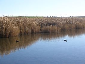
Tablas de Daimiel
|
|
| Area | 3,030 ha (11.7 sq mi) |
| Established | 1973 |
| Governing body | Ministry of the Environment |
| Official name: Las Tablas de Daimiel | |
| Designated: | 4 May 1982 |
| Reference #: | 235 |
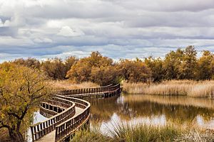
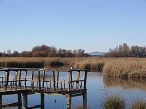
The Tablas de Daimiel National Park (Parque Nacional de las Tablas de Daimiel) is a special wetland area. It is located on the La Mancha plain in Ciudad Real, Spain. This area is mostly dry, but the park is a vital watery oasis.
The park covers about 3,000 hectares, which makes it the smallest of Spain's fifteen national parks. Efforts are being made to make the park even bigger. This expansion aims to help the wetland recover. The park has been harmed because too much water has been taken from its natural sources.
Besides being a national park, Tablas de Daimiel is important worldwide.
- It is a wetland listed under the Ramsar Convention, which protects wetlands.
- It is a key part of the Biosphere reserve called Mancha Húmeda.
- It is a Special Protection Area for birds, meaning it's a safe place for them.
Contents
History of Tablas de Daimiel
Like many wetlands in Spain, Tablas de Daimiel was once a popular place for hunting waterfowl. As far back as 1325, a prince named Don Juan Manuel wrote about how good the Gigüela riverbanks were for falconry. The area also provided fish and power for water mills.
In 1575, King Philip II ordered that the Tablas should be well cared for. Its value for hunting helped protect the area for a long time. In the 1950s, the government wanted to drain wetlands in La Mancha. However, Franco, who enjoyed duck hunting there, made the Tablas a National Hunting Reserve in 1966.
In 1963, a group called the International Union for the Conservation of Nature (IUCN) started a project to save wetlands. This project, called MAR, listed important wetlands around the world. The goal was to protect wetland habitats, not just specific animals. Because of this, Tablas de Daimiel was declared a National Park in 1973.
- In 1980, the national park grew larger.
- UNESCO added Las Tablas to a biosphere reserve.
- In 1982, Las Tablas joined the Ramsar Convention list. This is an international agreement to protect wetlands.
- In 1987, Las Tablas became a Special Protection Area for birds. This was under the European Union's Birds Directive.
What Makes the Park Special?
This park is the last example of a special type of wetland. These wetlands are found in the dry central part of Spain. The park is downstream from the Upper Guadiana Basin. This means it plays a big role in how nutrients move through the environment.
The park's landscape often gets flooded at different times of the year. Until recently, this flooding came from both rivers and underground water. The park covers about 19.28 square kilometers. When it's fully flooded, about 17 square kilometers are underwater.
Tablas de Daimiel is one of Spain's most important water ecosystems. It was likely the biggest inland wetland. It is also very important for many migratory birds. Birds like ducks and geese stop here on their long journeys.
Plants and Animals of the Park
Las Tablas de Daimiel has two types of water, which creates a unique environment. The Guadiana river brings fresh water. Its smaller river, the Gigüela, brings salty water.
Park Flora: Plants and Trees
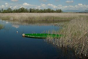
The fresh water from the Guadiana helps the Common Reed (Phragmites australis) grow. The salty water from the Gigüela helps marsh plants grow, especially the Great Fen-sedge (Cladium mariscus).
The Great Fen-sedge used to be very common here. It formed one of the largest areas of this plant in Western Europe. You could also find groups of Bulrushes (g. Typha, Scirpus lacustris, Scirpus maritimus) and Rush (g. Juncus) in shallower spots.
Charophytes are special algae that form underwater meadows. These meadows are a key feature of the park. They are made of different types of Chara (Chara hispida, Chara major, Chara canescens). Locals call them "ovas." They can form a thick, continuous carpet. The only trees in the park are tamarisk (Tamarix gallica, Tamarix canariensis).
Park Fauna: Animals and Birds
Migratory Birds of the Park
Many birds visit the park during their migrations. These include:
- Purple Heron (Ardea purpurea)
- Grey Heron (Ardea cinerea)
- Little Egret (Egretta garzetta)
- Black-crowned Night Heron (Nycticorax nycticorax)
- Great Bittern (Botaurus stellaris)
- Red-crested Pochard (Netta rufina)
- Northern Shoveler (Anas clypeata)
- Wigeon (Anas penelope)
- Northern Pintail (Anas acuta)
- Common Teal (Anas crecca)
- Eurasian Hobby (Falco subbuteo)
- Slavonian Grebe (Podiceps auritus)
- Black-necked Grebe (Podiceps nigricollis)
- Black-winged Stilt (Himantopus himantopus)
- Zitting Cisticola (Cisticola juncidis)
- Bearded Reedling (Panurus biarmicus)
Resident Animals of the Park
Some animals live in the park all year round. The European freshwater crayfish (Austropotamobius pallipes) used to be very common. It was an important source of income for local families. Sadly, it is now almost gone from these waters.
After the Northern pike (Esox lucius) was introduced, other native fish species became endangered. These include the Barbus (Barbus barbus), the Common carp (Cyprinus carpio), and the Chub (Leuciscus cephalus).
In spring and summer, you might see amphibians and reptiles. These include the European tree frog (Hyla arborea), the Perez's frog (Pelophylax perezi), and the Common Toad (Bufo bufo). You might also spot snakes like the Grass Snake (Natrix natrix) or the water snake Natrix maura.
Mammals found in the park include the European Polecat (Mustela putorius), the Red Fox (Vulpes vulpes), and the European Otter (Lutra lutra). The Water Vole (Arvicola amphibius) also lives here. Nearby, you can find the European Rabbit (Oryctolagus cuniculus), the Cape Hare (Lepus capensis), the Least Weasel (Mustela nivalis), and the Boar (Sus scrofa).
Challenges for Conservation
In recent years, the park has faced big problems. Farmers around the park need a lot of water for their crops. This has led to too much water being taken from underground sources. As a result, the water level in the ground has dropped.
The main underground water source, called "aquifer 23," has not been able to refill. This is due to overuse of water from a farming plan started in 1952. Also, there was not enough action from authorities. The amount of water allowed for users is almost double the amount that naturally refills each year.
To avoid a fine from the European Union, Spain proposed a plan in 1995. This plan involved building an aqueduct and pipes to bring water from the Tagus river to the upper Guadiana basin. This new water was only for cities and protected areas, not for farming. However, many people did not like this plan. They felt it meant the underground water sources would never recover. They also thought it was wrong to replace the natural water system with an artificial one. Conservation groups believed the solution should come from within the Guadiana basin itself.
Some environmental groups even suggested that the park should lose its biosphere reserve status. They felt its natural system was too broken. In 2008, UNESCO suggested the park lose its status. Or, Spain would be given a deadline to fix the damage. Spain was given time to make things better.
A special plan for the Upper Guadiana started in 2008. It had a budget of 5 million euros and would last 29 years. Its goal was to restore the wetlands. The European Union's Water Directive requires wetlands to be healthy by 2015. But it allows more time for very difficult cases, like Tablas de Daimiel. So, the deadline for this park is 2027. This plan includes a water bank system. It aims to set limits on water use based on social and environmental needs. It also looks at how efficiently water is used.
In May 2009, a plan was announced to use recycled water to help the wetland. But some environmentalists were doubtful. They pointed out that the underground water source would still not be refilled.
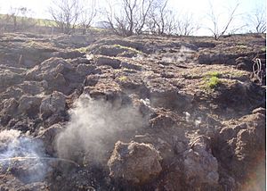
In the hot summer of 2009, dry peat caught fire underground in the area. These fires were not new to the region. They had affected peatlands near the Guadiana in past years. But when they appeared in the National Park, it showed how much the wetland had been damaged.
In early 2010, heavy rainfall helped improve the situation. However, experts say that the park won't truly get better without greatly reducing the amount of land used for irrigated cereals. Also, traditional dry-land crops and horticulture (which use water more efficiently) should be kept. The plan also includes buying water rights. This allows water to be used for the park's benefit. It also helps give water to more efficient users, like small farms growing vines and vegetables. These farms use less water and make more money per cubic meter of water.
Despite these plans, Spain's economic situation has meant there isn't enough money for this work.
European funding often goes to replanting forests on land that was cleared for growing cereals. Also, under Europe's current Common Agricultural Policy, cereals get more money than other crops. A review of this policy is planned for 2013. The decisions made then will be very important for the future of the Mancha Húmeda. Other local activities like solar electricity, ecotourism, and better quality farm products could also help. Environmental services, like carbon storage, are also important.
See also
 In Spanish: Parque nacional de las Tablas de Daimiel para niños
- Lagunas de Ruidera
 | Stephanie Wilson |
 | Charles Bolden |
 | Ronald McNair |
 | Frederick D. Gregory |


