Tenmile Creek (Coos County, Oregon) facts for kids
Quick facts for kids Tenmile Creek |
|
|---|---|

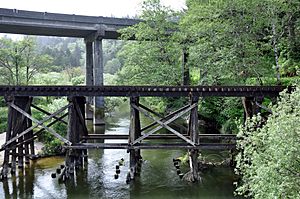
The creek passes under U.S. Route 101 and a railway trestle after leaving Tenmile Lake.
|
|
|
Location of the mouth of Tenmile Creek in Oregon
|
|
| Country | United States |
| State | Oregon |
| County | Coos |
| Physical characteristics | |
| Main source | Tenmile Lake Lakeside 14 ft (4.3 m) 43°34′24″N 124°10′24″W / 43.57333°N 124.17333°W |
| River mouth | Pacific Ocean 3 ft (0.91 m) 43°33′42″N 124°13′55″W / 43.56167°N 124.23194°W |
| Length | 3 mi (4.8 km) |
Tenmile Creek is a small river in Oregon, United States. It flows out of Tenmile Lake near the town of Lakeside. The creek is located in Coos County.
This creek flows generally west for about 3 miles (5 kilometers). It starts at the lake and ends in the Pacific Ocean. The name "Tenmile Creek" comes from its distance. It is about ten miles away from Winchester Bay. This was one of the first pioneer towns along that part of the coast.
The Creek's Journey
Tenmile Creek begins its journey at Lakeside. It winds its way generally west from there. The town of Lakeside is on the creek's right side.
A bit west of Lakeside, the creek enters the Siuslaw National Forest. It then flows under U.S. Route 101, a major highway. Soon after the highway, another creek called Eel Creek joins it. Eel Creek flows out of Eel Lake and enters Tenmile Creek from the right.
Tenmile Creek then turns south, flowing next to the highway. At Spinreel Campground, Saunders Creek joins Tenmile Creek from the left. Finally, Tenmile Creek turns northwest. It enters the Oregon Dunes National Recreation Area. The creek meanders through these sand dunes until it reaches the ocean.
How the Lakes Formed
Tenmile Lake is the biggest lake in a chain of lakes. It's also the southernmost one. These lakes formed behind a ridge of dunes along the Oregon Coast. This area is south of the Umpqua River.
The lakes developed after the last ice age. As the Earth warmed, sea levels rose. This caused the lower parts of Tenmile Creek and its smaller streams to fill with water. Later, sand dunes blocked these streams. This created lakes at different heights within the Tenmile drainage basin (the area of land that drains into the creek). Other large lakes in this chain include Clear Lake, Eel Lake, and North Tenmile Lake. All these lakes drain towards Lakeside. Lakeside is about 8 miles (13 km) south of Reedsport. It is also about 0.5 miles (0.8 km) east of U.S. Route 101.
Fun Activities
The United States Forest Service manages Spinreel Campground. This campground is near where Tenmile and Saunders Creeks meet. It's also at the edge of the sand dunes.
Spinreel Campground has a boat ramp for boats without motors. It also has a special area for dune buggies. At the campground, you can go fishing for steelhead. Steelhead are a type of rainbow trout that live in the ocean. You can also have a picnic or camp there in an recreational vehicle (RV).
 | George Robert Carruthers |
 | Patricia Bath |
 | Jan Ernst Matzeliger |
 | Alexander Miles |


