
The Battery (Charleston) facts for kids


The Battery is a famous seawall and walking path in Charleston, South Carolina. It's named after a group of cannons (an 'artillery battery') that defended the coast during the American Civil War. The Battery stretches along the edge of the Charleston peninsula, where the Ashley River and Cooper River meet to form Charleston Harbor. It's a popular spot for locals and visitors to enjoy the views.
Contents
Where is The Battery Located?
The Battery starts near East Bay Street and goes all the way to Murray Boulevard and King Street. The higher part of the seawall, called High Battery, runs along East Battery street. From the High Battery, you can see important historical sites like Fort Sumter, Castle Pinckney, and Fort Moultrie. You can also spot the World War II aircraft carrier USS Yorktown (CV-10) and Sullivan's Island.
Sometimes, people call The Battery and White Point Garden "Battery Park." However, the City of Charleston sees them as separate places. "Battery Park" is not an official name.
A Look Back: History of The Battery
The area where The Battery is today has been important for defense for a long time. Early forts like Fort Broughton (around 1735) and Fort Wilkins (during the American Revolution and War of 1812) were built on White Point. This point was named for the many white oyster shells found there.
In the 1700s, people used rocks and heavy materials to strengthen the shore along the Cooper River. By 1838, this fortified area became a public walking path. The area now known as White Point Garden was first used as a public park in 1837. During the American Civil War, it became a place for cannons to defend the city.
Many forts and defense points were located around The Battery over the years. For example, Colleton Bastion was near Water and Meeting Streets. During the Siege of Charleston, British forces faced several forts, including Fort Johnson and Wilkins' Fort. Later, during the Quasi-War (around 1795), Fort Mechanic stood where the Edmondston–Alston House is today. During the Civil War, Battery Ramsay was located in White Point Garden.
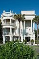
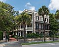
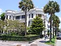
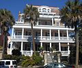
Beautiful Homes Along The Battery
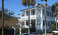
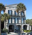
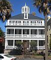
The Battery is famous for its grand, old homes, many built before the Civil War. These homes show off beautiful Antebellum architecture. Some of the well-known houses include:
- The Louis DeSaussure House (1 East Battery)
- The Roper House (9 East Battery)
- The William Ravenel House (13 East Battery)
- The Edmondston–Alston House (21 East Battery)
- The Charles Drayton House (25 East Battery)
- The George Chisolm House (39 East Battery)
- The Villa Margherita (4 South Battery)
- The William Washington House (8 South Battery)
- The Col. John A.S. Ashe House (26 South Battery)
- The James Spear House (30 South Battery)
- The Col. John Ashe House (32 South Battery)
The Battery Today

In 2004, a report showed that The Battery was getting old and might not protect Charleston well during hurricanes. So, in 2012, the city started a big project to fix it. This $3.2 million restoration helped make sure The Battery stays strong and safe for years to come.
Images for kids
-
Porcher-Simonds House, 29 East Battery
-
Edmondston-Alston House, 21 East Battery
-
Intersection of Atlantic and E Battery Streets
-
20 South Battery, a boutique hotel
-
George Chisolm House, 39 East Battery
-
William Ravenel House, 13 East Battery
-
Col. John Ashe House, 32 East Battery


