The Monarch (Canadian Rockies) facts for kids
Quick facts for kids The Monarch |
|
|---|---|

The Monarch
|
|
| Highest point | |
| Elevation | 2,895 m (9,498 ft) |
| Prominence | 555 m (1,821 ft) |
| Parent peak | Mount Brett (2984 m) |
| Listing | Mountains of British Columbia |
| Geography | |
| Location | British Columbia, Canada |
| Parent range | Ball Range, Canadian Rockies |
| Topo map | NTS 82.O.04 |
| Geology | |
| Age of rock | Cambrian |
| Type of rock | sedimentary rock |
| Climbing | |
| First ascent | 1913 Conrad Kain with Interprovincial Boundary Survey |
| Easiest route | Scrambling |
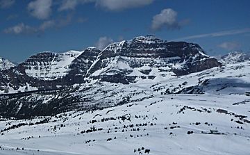
The Monarch is a tall mountain in the Canadian Rockies in British Columbia, Canada. It stands about 2,895-metre (9,498-foot) high. This mountain is special because it sits right on the edge of two big parks: Kootenay National Park and Mount Assiniboine Provincial Park. It's also near the Continental Divide, which is like a big line that separates where water flows either east or west. Even though you can't see it from the main roads, The Monarch is easy to spot from the ski slopes at Sunshine Village resort. The closest higher mountain is Mount Bourgeau, which is about 10 kilometers (6 miles) away to the north.
Contents
Mountain History
First Climbers
The first time someone successfully climbed The Monarch was in 1913. A famous climber named Conrad Kain made the climb. He was part of a group called the Interprovincial Boundary Survey. This group was mapping the area.
Naming The Monarch
In a report from the survey, the mountain was called "Monarch Mountain." They said it was a beautiful mountain that stood out in the Simpson Pass area. The mountain's name became official in 1924. This happened when the Geographical Names Board of Canada approved it.
Geology of The Monarch
How the Mountain Formed
The Monarch is made of sedimentary rock. This type of rock forms from layers of sand, mud, and tiny bits of sea creatures. These layers were laid down a very long time ago, from the Precambrian to the Jurassic periods.
Rock Movement
These rocks formed in shallow seas. Over millions of years, huge forces pushed these sedimentary rocks. This movement happened during an event called the Laramide orogeny. It caused the older rocks to be pushed up and over younger rocks. This is how the mountain got its shape.
Climate and Weather
Mountain Climate
The Monarch is in a subarctic climate zone. This means it has very cold and snowy winters. The summers are usually mild. Temperatures can drop below -20 °C ( -4 °F). With the wind chill, it can feel even colder, sometimes below -30 °C (-22 °F).
Water Flow
When snow melts or rain falls on The Monarch, the water flows off the mountain. This water goes into small streams that feed into the Simpson River. The Simpson River then flows into the Vermilion River.
 | Aaron Henry |
 | T. R. M. Howard |
 | Jesse Jackson |


