The Oaks, New South Wales facts for kids
Quick facts for kids The OaksNew South Wales |
|||||||||||||||
|---|---|---|---|---|---|---|---|---|---|---|---|---|---|---|---|

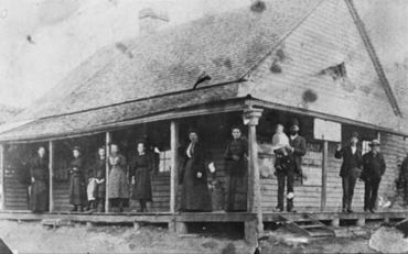
The Oaks Post Office in 1890
|
|||||||||||||||
| Population | 2,525 (2016 census) | ||||||||||||||
| Established | 1820s | ||||||||||||||
| Postcode(s) | 2570 | ||||||||||||||
| Elevation | 290 m (951 ft) | ||||||||||||||
| Location | |||||||||||||||
| LGA(s) | Wollondilly Shire | ||||||||||||||
| State electorate(s) | Wollondilly | ||||||||||||||
| Federal Division(s) | Hume | ||||||||||||||
|
|||||||||||||||
The Oaks is a town in the Macarthur Region of New South Wales, Australia. It is part of Wollondilly Shire, located on the edge of the Sydney Basin. The town is about 82 kilometers (51 miles) south-west of Sydney. It is also 13 kilometers (8 miles) west of Camden. The Oaks sits 290 meters (951 feet) above sea-level. In 2016, The Oaks and its nearby areas had a population of 2,525 people.
Even though coal mining was important for a long time, The Oaks has mostly stayed a pretty country area. It is close to Sydney, which has led to some new buildings.
Contents
First Peoples of The Oaks
The land around The Oaks was once home to the Tharawal people. Their traditional lands stretched from Botany Bay to Jervis Bay. They also lived in the Burragorang area. The Tharawal people and European settlers had many conflicts. This happened especially between 1812 and 1816. A sad event occurred at Cataract Gorge. Here, a group of Gandangara people near Appin were attacked by soldiers. At least fourteen Aboriginal people, including children, died. The bodies of two men were hung in trees as a warning. This was done on Governor Macquarie's orders.
New diseases brought by Europeans greatly affected the Aboriginal people. The Tharawal and Gandangara people eventually moved closer to The Oaks. In the 1920s, members of both groups worked for Europeans. They were placed on special reserves. Their children were also taken from their families. This practice continued until the 1960s.
How The Oaks Got Its Name
The Oaks was simply called "Oaks" until 1895. In 1795, an exploration trip happened. Governor Hunter and George Bass were on this trip. They were looking for cows that had wandered off. These cows were from a government farm in Farm Cove. The small herd of 8 cows had grown to about 40. The area where they found the cows was named "Cow Pasture Plains."
In 1803, John Warby became the boss of the wild cattle. He was also a local police officer. Warby helped guide many exploring groups. He was the first person to explore the Oaks region. A plant expert named George Caley also explored the area. He was there between 1802 and 1804. Caley gave the name "The Oaks" to the area. He did this because there were many She-oak trees there.
In 1815, Governor Macquarie set up cattle yards in "The Oaks." These yards were also in Cawdor and Brownlow Hill. Wild cattle were brought here to be tamed. On July 7, 1822, Major Henry Colden Antill took over the Oaks cattle station. Many cattle were later moved to Bathurst. The cattle stations closed in 1826.
Early Settlers and Farms
The area was surveyed between 1822 and 1827. This was when land grants were given out. The first grant was given in 1823 to John Wild. He was a former officer in the army. Wild had been in charge of government cattle at Cawdor. He started a farm called "Vanderville." He built a home in the late 1820s. Aboriginal people and convicts helped him. Wild mostly raised cattle. But he also had sheep and pigs. He grew wheat and tobacco, and had a dairy farm.
In October 1822, William Fisher was a police officer in "The Oaks." He was later recommended to be the main police officer in Cawdor. He lost this job but became a district police officer in August 1824.
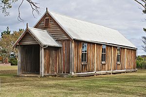
St. Mathews Anglican Church was built around 1838-1839. The families of John Wild and Major Russell built it. It was for their workers and families. The church was made from local timber. It still stands today. It has been repaired twice to keep it safe. The church cemetery has the gravestone of Henry Kable Jr. He was the son of Henry Kable. Other coffins were moved here from Burragorang Valley. This was before the valley was flooded to build Warragamba Dam.
Farming in The Oaks
Farmers from Camden, Campbelltown, and The Oaks used to graze their cattle in the Burragorang Valley. Francis Barrallier explored this valley in 1802-1803. He was asked by Governor King to find a way through the Blue Mountains. Farmers likely drove their cattle along what is now Burragorang Road. This road goes from The Oaks to the Burragorang Valley. Robert Dixon surveyed it in 1827. It was just a basic track for bullock carts. Later, it was improved because of traffic from silver mines.
It became hard to find enough workers. This was after convict transportation to New South Wales stopped in 1840. Convicts then received their ticket of leave, which meant they were free. Free settlers with large land areas sold or rented parts of their land. They sold to former convicts because they could not afford enough workers. The main type of farming then changed. From the 1840s, it focused on wheat. A wheat mill was built in the area. The 1850s were a time of growth for the area.
In the early 1860s, a plant disease called wheat rust destroyed the wheat industry. Farmers then changed what they grew. They focused on market gardening, dairy farming, and making hay. They also built hay presses. Oranges and milk became important products.
Mining in The Oaks Area
George Caley explored the Burragorang Valley again in 1806. He also tried to cross the Blue Mountains but could not. However, he found coal in the valley. He also discovered Thirlmere Lakes. Later, Billy Russell and Billy George found Galena, a lead ore. This led to a short period of mining activity at Yerranderie. People became interested in mining Lead and Silver in 1890. But real growth in silver mining happened in 1898. This was when John Vigar Bartlett started finding enough ore to make money.
In 1891, mining for iron ore began. This was in the area between The Oaks and Picton. After some economic growth in the 1920s, the Great Depression hit hard. Many people moved away from the community. Coal mining and timber cutting also happened in the Burragorang Valley. This was at Nattai on a small scale in the 1930s. But it soon became the main economic activity. After World War II, the town grew again. However, many people lost their jobs at the local mines in the early 1980s.
The Village of Vanderville
Emmeline Wild was the widow of John Benton Wild. In 1858, she gave 100 acres (0.4 square kilometers) of her "Vanderville" land. This land was for starting a new village. It was located by the Werriberri Creek. This is a Tharawal name for the song of the willie wagtail bird. Flooding caused the settlement to move to higher ground.
When a post office opened later in 1858, the village was officially named "The Oaks." Land lots were advertised for sale in Sydney. By 1860, there were about 8 houses in the village. There were also 2 blacksmith shops, a wine saloon, a school, and a hotel. The Oaks Hotel opened by 1863. It closed about 100 years later. It then became a sanatorium for people with Tuberculosis. People thought the high altitude was good for patients' health.
The original St. Mathews Church was now too far from the new village. So, St. Luke's Church was built in 1892. It was built on a town plot to serve the new village.
 | Georgia Louise Harris Brown |
 | Julian Abele |
 | Norma Merrick Sklarek |
 | William Sidney Pittman |


