The Priest (mountain) facts for kids
Quick facts for kids The Priest ( DePriest) |
|
|---|---|

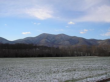
Priest Mountain as seen from Massies Mill, Va. 12-5-2010
|
|
| Highest point | |
| Elevation | 4,063 ft (1,238 m) |
| Prominence | 800 ft (240 m) |
| Geography | |
| Location | Nelson County, Virginia |
| Parent range | Blue Ridge Mountains |
| Topo map | USGS Massies Mill |
| Climbing | |
| Easiest route | Hike |
The Priest (also known as DePriest) is a tall mountain located in Nelson County, Virginia. It's the highest point in the entire county! This mountain is part of the beautiful Blue Ridge Mountains, which are famous for their misty, blue appearance. The Priest is a great place for outdoor adventures and exploring nature.
Contents
Exploring The Priest Mountain
The Priest mountain stands proudly in Nelson County, Virginia. Its very top, called the peak, is the highest spot in the whole county! Imagine standing on the highest point around – that's what you'd be doing on The Priest.
Where is The Priest Located?
This mountain is a part of the amazing Blue Ridge Mountains. It's found about 3.5 miles (5.5 kilometers) east of another mountain called Maintop Mountain. The Priest is also located within the Priest Wilderness area, which is part of the huge George Washington National Forest. This means it's a wild and natural place!
Water Flowing from The Priest
The Priest mountain is important for the water that flows from it. All the rain and snow that falls on the mountain eventually makes its way into the Tye River. This area is called a drainage basin or watershed, which is like a giant funnel that collects water and sends it to a main river.
- Water from the north side of The Priest flows into Coxs Creek, then into the Tye River.
- Water from the south side flows into Rocky Run, also heading to the Tye River.
- Water from the west side goes into Shoe Creek, then into the Piney River, and finally into the Tye River.
All this water eventually joins the larger James River.
Hiking the Appalachian Trail
One of the most exciting things about The Priest is that the famous Appalachian Trail runs right over its top! The Appalachian Trail is a super long hiking path, stretching for 2,193 miles (3,529.29 kilometers) from Georgia all the way to Maine. It's a National Scenic Trail, meaning it's protected for its natural beauty.
You can reach the top of The Priest by hiking on the Appalachian Trail. There's a starting point, called a trailhead, along Virginia State Route 56. The hike to the summit is quite a climb, gaining about 3,000 feet (914 meters) in height from the bottom to the very top!
Amazing Crabtree Falls
On the northwest side of The Priest, you'll find Crabtree Falls. This is a beautiful series of waterfalls that tumble down the mountain. It's one of the tallest waterfalls east of the Mississippi River! You can use the Crabtree Falls trail and Forest Development Road 826 to get to the Appalachian Trail and then continue your hike to the summit of The Priest. It's a wonderful spot to visit and see the power of nature.
 | Sharif Bey |
 | Hale Woodruff |
 | Richmond Barthé |
 | Purvis Young |

