The Summit, Queensland facts for kids
Quick facts for kids The SummitQueensland |
|||||||||||||||
|---|---|---|---|---|---|---|---|---|---|---|---|---|---|---|---|

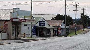
Granite Belt Drive (main street), The Summit, 2015
|
|||||||||||||||
| Population | 436 (2021 census) | ||||||||||||||
| • Density | 26.42/km2 (68.4/sq mi) | ||||||||||||||
| Postcode(s) | 4377 | ||||||||||||||
| Elevation | 923.5 m (3,030 ft) | ||||||||||||||
| Area | 16.5 km2 (6.4 sq mi) | ||||||||||||||
| Time zone | AEST (UTC+10:00) | ||||||||||||||
| Location |
|
||||||||||||||
| LGA(s) | Southern Downs Region | ||||||||||||||
| State electorate(s) | Southern Downs | ||||||||||||||
| Federal Division(s) | Maranoa | ||||||||||||||
|
|||||||||||||||
The Summit is a small country town and area in Queensland, Australia. It is part of the Southern Downs Region. In 2021, about 436 people lived in The Summit.
This area is special because it shares a border with New South Wales.
Contents
Exploring The Summit's Location
The Summit is mostly made up of farms. You can also find some buildings around the railway station. The New England Highway goes through the town from north to south. It runs very close to the Southern railway line.
The highway used to be the main street of the town. Now, it goes around the town to the east. Cannon Creek forms the border on the southwest side of the area.
A Look Back at The Summit's Past
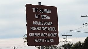
The town got its name from The Summit railway station. This station was named "The Summit" because it was the highest point on the Southern railway line. This railway line goes from Warwick to Wallangarra. The highest point is 923.5 meters (about 3,029 feet) above sea level.
Early Schools and Churches
The Summit State School first opened its doors on August 29, 1921. This school has been teaching local children for over 100 years.
The Summit Methodist Church started holding services on August 18, 1915. Later, in 1977, the Methodist Church joined with other churches to form the Uniting Church in Australia. So, it became The Summit Uniting Church. This church closed on November 18, 2017. The building is still there, but it is now a house.
St John's Anglican Church was officially opened on November 28, 1926. The Seventh-Day Adventist Church opened in 1989.
Who Lives in The Summit?
The number of people living in The Summit changes over time.
- In 2011, there were 484 people.
- In 2016, the population was 409 people.
- In 2021, the number of residents was 436 people.
Learning in The Summit
The Summit State School is a government primary school. It teaches students from Prep (the first year of school) to Year 6. Both boys and girls attend this school. In 2018, there were 31 students.
There is no high school in The Summit itself. Students who want to go to secondary school usually go to Stanthorpe State High School. This school is located in Stanthorpe, which is south of The Summit.
Community Places in The Summit
The Summit has several important places for the community.
Public Hall
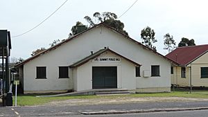
The Summit Public Hall is a place where people can gather for events. It is located at 101 Granite Belt Drive, right across from the railway station.
Churches in The Summit
- St John's Anglican Church is at 7 Teale Road. It is part of the Stanthorpe Parish.
- The Summit Seventh Day Adventist Church is at 25 Church Road.
 | James Van Der Zee |
 | Alma Thomas |
 | Ellis Wilson |
 | Margaret Taylor-Burroughs |


