Throop, New York facts for kids
Quick facts for kids
Throop, New York
|
|
|---|---|
| Motto(s):
Small town atmosphere, outstanding quality of life
|
|

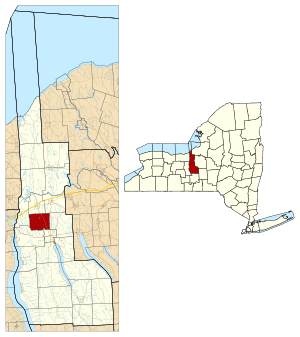
Location in Cayuga County and New York
|
|
| Country | United States |
| State | New York |
| County | Cayuga |
| Settled | 1790 |
| Created | 1859 |
| Government | |
| • Type | Town Council |
| Area | |
| • Total | 18.70 sq mi (48.42 km2) |
| • Land | 18.59 sq mi (48.14 km2) |
| • Water | 0.11 sq mi (0.29 km2) |
| Elevation | 620 ft (189 m) |
| Population
(2010)
|
|
| • Total | 1,990 |
| • Estimate
(2016)
|
1,958 |
| • Density | 105.35/sq mi (40.68/km2) |
| Time zone | UTC-5 (Eastern (EST)) |
| • Summer (DST) | UTC-4 (EDT) |
| ZIP code |
13021
|
| Area code(s) | 315 |
| FIPS code | 36-011-73770 |
| GNIS feature ID | 0979544 |
Throop (pronounced TROOP) is a small town located in Cayuga County, New York, United States. It sits just north of the city of Auburn. Throop is part of the scenic Finger Lakes region of New York. In 2010, about 1,990 people lived there. The town is named after Enos T. Throop, who used to be the Governor of New York and lived in Cayuga County.
History of Throop
The land where Throop is now was once used for hunting by the Cayuga people. Later, this area became part of the Central New York Military Tract. This was land set aside for soldiers who fought in wars. People started settling here around 1790.
The town of Throop was officially created in 1859. It was formed from parts of three other towns: Aurelius, Mentz, and Sennett. Throop is known for its many houses painted in different colors. You can see everything from light gray to a shiny bronze.
Throop's Geography
Throop covers a total area of about 48.4 square kilometers (about 18.7 square miles). Most of this area, about 48.1 square kilometers (18.6 square miles), is land. A small part, about 0.3 square kilometers (0.11 square miles), is water.
New York State Route 38 is a main road that runs north and south through Throop.
The Owasco Outlet is a small river that flows through the town. It starts at Owasco Lake and flows north towards the Seneca River.
People of Throop
| Historical population | |||
|---|---|---|---|
| Census | Pop. | %± | |
| 1860 | 1,348 | — | |
| 1870 | 1,302 | −3.4% | |
| 1880 | 1,188 | −8.8% | |
| 1890 | 1,056 | −11.1% | |
| 1900 | 1,038 | −1.7% | |
| 1910 | 960 | −7.5% | |
| 1920 | 958 | −0.2% | |
| 1930 | 990 | 3.3% | |
| 1940 | 1,083 | 9.4% | |
| 1950 | 1,251 | 15.5% | |
| 1960 | 1,559 | 24.6% | |
| 1970 | 1,757 | 12.7% | |
| 1980 | 1,797 | 2.3% | |
| 1990 | 1,792 | −0.3% | |
| 2000 | 1,824 | 1.8% | |
| 2010 | 1,990 | 9.1% | |
| 2016 (est.) | 1,958 | −1.6% | |
| U.S. Decennial Census | |||
According to the 2000 census, 1,824 people lived in Throop. There were 700 households, and 539 of them were families. The population density was about 97.8 people per square mile.
About 30.9% of households had children under 18 living there. Most households, 65.3%, were married couples living together. About 19.3% of all households were people living alone.
The population was spread out by age. About 23.1% were under 18 years old. About 28.4% were between 25 and 44 years old. The average age in Throop was 40 years. For every 100 females, there were about 102.7 males.
Places in Throop
- Cold Spring – This is a small community, called a hamlet, located at the northern edge of Auburn on NY-38.
- Polk Corners – You can find this spot west of Throopsville.
- Sawyers Corner – Another hamlet north of Auburn, also on NY-38.
- Throop – This is the main hamlet of Throop. It's located east of Sawyers Corner, near the eastern border of the town.
- Throopsville – This hamlet is west of Sawyers Corners, near the Owasco Outlet. People first settled here in 1799.
See also
 In Spanish: Throop (Nueva York) para niños


