Tickencote facts for kids
Quick facts for kids Tickencote |
|
|---|---|
 St Peter's Church, Tickencote |
|
| Area | 2.02 sq mi (5.2 km2) |
| Population | 67 2001 census |
| • Density | 33/sq mi (13/km2) |
| OS grid reference | SK990096 |
| • London | 83 miles (134 km) SSE |
| Unitary authority | |
| Shire county | |
| Ceremonial county | |
| Region | |
| Country | England |
| Sovereign state | United Kingdom |
| Post town | STAMFORD |
| Postcode district | PE9 |
| Dialling code | 01780 |
| Police | Leicestershire |
| Fire | Leicestershire |
| Ambulance | East Midlands |
| EU Parliament | East Midlands |
| UK Parliament |
|
| Website | Village website |
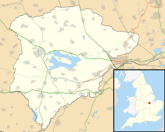
Tickencote is a small village in Rutland, a county in the East Midlands of England. It's famous for St Peter's Church, which has an amazing Norman arch.
In 2001, only 67 people lived there. By 2011, the population was still small, so it was counted with the nearby village of Great Casterton.
Contents
Exploring Tickencote's Location
Tickencote is located along the A1 highway, which was once an old Roman road called Ermine Street. The village stretches from the Bloody Oaks area to the Casterton road junction.
To the north-west of Tickencote is Empingham. On its southern side, it shares a border with Great Casterton. The village's boundaries cross the A1 highway in a few places.
Roadside Services
If you're traveling north on the A1, you'll find the Bloody Oaks Service Station. It has an OK Diner where you can grab a bite to eat. There's also a JET petrol station to refuel your car. This service station is a handy stop for northbound travelers.
Walking and Cycling Paths
The Rutland Round is a special footpath that goes right through Tickencote. It follows the B1081 road and even passes under the A1 highway.
You can also cycle through the village on National Cycle Route 63. This route takes you from Cross Roads Farm, along the B1081, and continues towards Stamford.
Local Nature Reserves
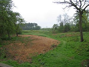
Tickencote is home to two interesting nature spots. One is Bloody Oaks Quarry, a 1.3-hectare nature reserve. It's also a SSSI, which means it's a very important place for nature. This area used to be a quarry where limestone was dug out.
You can find some special plants here, like chalk milkwort, which is rare in northern England. Other plants include horseshoe vetch, yellow-wort, and common thyme. You might even spot beautiful Pyramidal and Bee Orchids.
Tickencote Marsh is another important nature reserve, covering 3 hectares. It's a marshy area in the valley of the River Gwash. This type of marsh is becoming rare, so it's important to protect it. You can see plants like lesser pond-sedge and marsh horsetail growing there.
Tickencote's Past
The name 'Tickencote' means 'shed of young goats'. It gives us a clue about what the area might have been like long ago.
St Peter's Church

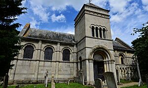
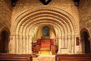
The village is famous for St Peter's Church, Tickencote. It has an amazing Norman chancel arch. This arch is very old and has many detailed carvings. You can see zigzags, animals, and other patterns. The church was partly rebuilt in 1792 by Samuel Pepys Cockerell.
From 1909 to 1912, a vicar named Lonsdale Ragg worked at the church. He later became an important church leader in Gibraltar.
Famous Visitors and Writers
The poet John Clare used to visit the Flowerpot Inn in Tickencote. This building is now a private home called Flower Pot Cottage. In 1903, the writer William Le Queux wrote a book called The Tickencote Treasure, inspired by the village.
Tickencote Hall
Tickencote Hall was a large house built in 1705. It was the home of the Wingfield family. They helped restore the church. The hall was taken down in 1950.
Road Changes Over Time
In 1960, a new road called the Stamford Bypass was built. It ended with a roundabout in Tickencote. This roundabout was known for trucks sometimes tipping over.
Later, in 1971, a new section of the dual carriageway was opened. This made travel easier and safer.
The Old Watermill
Tickencote also had a watermill that stopped being used in the 1930s. Records suggest there was a mill here as early as the 4th century AD. The current mill building has a sign saying it was built in 1731 by John Wingfield.
 | Sharif Bey |
 | Hale Woodruff |
 | Richmond Barthé |
 | Purvis Young |


