Tippah County, Mississippi facts for kids
Quick facts for kids
Tippah County
|
|
|---|---|

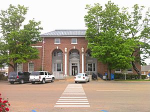
The Tippah County courthouse in Ripley
|
|

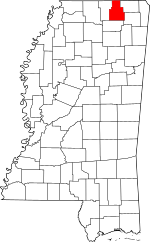
Location within the U.S. state of Mississippi
|
|
 Mississippi's location within the U.S. |
|
| Country | |
| State | |
| Founded | 1836 |
| Named for | Chickasaw language word meaning "Cut off" |
| Seat | Ripley |
| Largest city | Ripley |
| Area | |
| • Total | 460 sq mi (1,200 km2) |
| • Land | 458 sq mi (1,190 km2) |
| • Water | 2.1 sq mi (5 km2) 0.5% |
| Population
(2020)
|
|
| • Total | 21,815 |
| • Estimate
(2023)
|
21,287 |
| • Density | 47.4/sq mi (18.31/km2) |
| Time zone | UTC−6 (Central) |
| • Summer (DST) | UTC−5 (CDT) |
| Congressional district | 1st |
Tippah County is a special area called a county. It is found in the northern part of Mississippi, a state in the United States. In 2020, about 21,815 people lived here.
The main town and center of the county is Ripley. This is where the county government offices are located. The name "Tippah" comes from the Chickasaw language. It means "cut off." This name was given because of a creek that flows through the area. The creek and nearby hills seemed to "cut off" one part of the land from another.
Did you know that one of President Bill Clinton's great-grandfathers is buried in Tippah County?
Contents
Geography of Tippah County
Tippah County covers about 460 square miles. Most of this area is land, around 458 square miles. A small part, about 2.1 square miles, is water.
Main Roads in Tippah County
These are the important highways that run through Tippah County:
Neighboring Counties
Tippah County shares its borders with these other counties:
- Hardeman County, Tennessee (to the north)
- Alcorn County (to the northeast)
- Prentiss County (to the southeast)
- Union County (to the south)
- Benton County (to the west)
Protected Natural Areas
Part of the Holly Springs National Forest is located within Tippah County. This is a large area of protected land.
People of Tippah County
| Historical population | |||
|---|---|---|---|
| Census | Pop. | %± | |
| 1840 | 9,444 | — | |
| 1850 | 20,741 | 119.6% | |
| 1860 | 22,550 | 8.7% | |
| 1870 | 20,727 | −8.1% | |
| 1880 | 12,867 | −37.9% | |
| 1890 | 12,951 | 0.7% | |
| 1900 | 12,983 | 0.2% | |
| 1910 | 14,631 | 12.7% | |
| 1920 | 15,419 | 5.4% | |
| 1930 | 18,658 | 21.0% | |
| 1940 | 19,680 | 5.5% | |
| 1950 | 17,522 | −11.0% | |
| 1960 | 15,093 | −13.9% | |
| 1970 | 15,852 | 5.0% | |
| 1980 | 18,739 | 18.2% | |
| 1990 | 19,523 | 4.2% | |
| 2000 | 20,826 | 6.7% | |
| 2010 | 22,232 | 6.8% | |
| 2020 | 21,815 | −1.9% | |
| 2023 (est.) | 21,287 | −4.3% | |
| U.S. Decennial Census 1790-1960 1900-1990 1990-2000 2010-2013 |
|||
In 2020, there were 21,815 people living in Tippah County. These people lived in 7,834 households. About 5,394 of these households were families.
Communities in Tippah County
Tippah County has several towns and communities.
City
- Ripley (This is the main county seat)
Towns
Census-Designated Place
- Chalybeate (This is a special kind of community recognized for census data)
Unincorporated Communities
These are smaller places that are not officially organized as cities or towns:
- Brownfield
- Tiplersville
- Lake Mohawk
- Dry Creek
- Cotton Plant
- Camp Hill
Local News and Media
You can find local news about Tippah County at TippahNews.com.
Education in Tippah County
The county has two main school districts for students:
- North Tippah School District
- South Tippah School District
For higher education, Northeast Mississippi Community College serves students from Tippah County.
See also
 In Spanish: Condado de Tippah (Misisipi) para niños


