
Tiruvallur district facts for kids
Quick facts for kids
Tiruvallur district
Thiruvallur district
|
|
|---|---|
| Country | |
| State | |
| Region | Pallava Nadu, Tondai Nadu |
| Headquarters | Tiruvallur |
| Talukas | Avadi RK Pet Ponneri Gummidipoondi Uthukottai Tiruvallur Poonamallee Tiruttani Pallipattu |
| Area | |
| • Total | 3,423 km2 (1,322 sq mi) |
| Population
(2011)
|
|
| • Total | 2,721,363 |
| • Rank | 4 |
| • Density | 795.02/km2 (2,059.10/sq mi) |
| Languages | |
| • Official | Tamil |
| Time zone | UTC+5:30 (IST) |
| PIN |
602001.600XXX,601XXX,631XXX
|
| Telephone code | 044 |
| Vehicle registration | TN-12, 13, 18, 20. |
| Largest metro | Avadi |
| Sex ratio | 983 ♂/♀ |
| Literacy | 83.33% |
| Central location: | 13°8′N 79°54′E / 13.133°N 79.900°E |
| Avg. summer temperature | 37.9 °C (100.2 °F) |
| Avg. winter temperature | 18.5 °C (65.3 °F) |
Tiruvallur district, also known as Thiruvallur district, is one of the 38 districts in the Indian state of Tamil Nadu. It is an important administrative area. The city of Tiruvallur is the main headquarters of the district. This district has a mix of busy city areas and peaceful rural areas. Its eastern part is mostly urban, while the northern part shows some influence from the culture of Andhra Pradesh due to its location. In 2011, the district had a population of over 3.7 million people. For every 1,000 males, there were 987 females.
The district is divided into three main parts for administration: Tiruvallur, Tiruttani, and Ponneri. These divisions contain several smaller areas called taluks. There are also 46 firkas and 820 villages that collect revenue. For local development, there are 12 blocks, five municipalities, and ten town panchayats.
Contents
What's in a Name? The Story of Tiruvallur
The name "Tiruvallur" comes from a Tamil phrase, "tiru evvull?". "Tiru" is a special word often added to names of temple towns in South India. It means "highness" or "sacred". "Evvull" means "where do I sleep?". So, Tiruvallur means a place where the god Veera Raghavar asked a saint for a place to sleep for one night.
Tiruvallur was first called Tiru-evallur. This name describes the sleeping position of the god Vishnu, also known as "Perumal", in the Veeraragava temple. Over time, people started calling it Trivellore and then Tiruvallur. Today, the Veeraragava Temple is very famous. Many people visit it, especially on Amavasya (the start of the dark moon period before the new moon), which is a special day for the god and the town.
The Tiruvallur district was created by splitting the older Chengalpattu district. This happened around the time of the 1991 Census. Parts of the old Chengalpattu district, including Tiruvallur, Tiruttani, Uthukkottai, and Pallipattu, joined with Ponneri and Gummindipoondi from another area to form this new district. Currently, Tiruvallur district has 9 taluks: Avadi, RK Pet, Ponneri, Gummidipoondi, Uthukottai, Tiruvallur, Poonamallee, Tiruttani, and Pallipattu.
In the past, this region was ruled by many different groups. It started with the Pallavas in the 7th century. Later, the Golkonda rulers and then the Moghul emperors of Delhi took control. In the 18th century, this area saw many battles during the Carnatic wars. These wars were fought between the English and French who were trying to gain control of India. The town of Pulicat was an early Dutch trading post, set up in 1609. It was given to the British in 1825. After this, the whole region came under British rule until India became independent on August 15, 1947.
How Tiruvallur District is Governed
Tiruvallur District is managed through different administrative levels.
Revenue Divisions and Taluks
The district has three main revenue divisions, each overseeing several taluks:
- Ponneri Revenue Division: Includes Ponneri taluk and Gummidipoondi taluk.
- Tiruvallur Revenue Division: Includes Uthukkottai taluk, Tiruvallur taluk, Poonamallee taluk, and Avadi taluk.
- Tiruttani Revenue Division: Includes Tiruttani taluk, Pallipattu taluk, and RK Pet taluk.
Some of these taluks, like Avadi and Poonamallee, are part of the larger Chennai Metropolitan Area.
Cities and Towns
Tiruvallur District has one big city managed by a municipal corporation:
- Avadi
There are also six municipalities, which are smaller cities or large towns:
- Poonamallee
- Tiruverkadu
- Thirunindravur
- Tiruvallur
- Ponneri
- Thiruthani
The district also has several Town Panchayats, which are smaller towns:
- Gummidipoondi
- Minjur
- Naravarikuppam (which includes Red Hills)
- Thirumazhisai
- Arani
- Pallipattu
- Pothatturpettai
- Uthukottai
Local Development Blocks
For rural development, the district has several Panchayat Unions, also known as revenue blocks:
- Ellapuram
- Gummidipoondi
- Kadambathur
- Minjur
- Pallipattu
- Poonamallee
- Poondi
- Pulal
- R.K.Pet
- Sholavaram
- Tiruvallur
- Tiruttani
- Thiruvalangadu
- Villivakkam
Politics
The district is represented in the state's legislative assembly, with elected members working for the people of Tiruvallur.
Geography of Tiruvallur District
Tiruvallur district is located in a key area. To its north are the Tirupati and Chittoor districts of Andhra Pradesh state. To the east is the Bay of Bengal. Chennai district is to its southeast. To the south, it borders Kanchipuram and Chengalpattu districts. On the northwest, it touches Vellore, and on the west, Ranipet district.
The areas near the coast are mostly flat. However, other parts of the district have rolling hills and some hilly sections. The northern taluks like Ponneri, Uttukkottai, and Gummidipundi do not have many scenic views. In the Tiruttani taluk, you can find several small hills scattered around.
The soil in the district is mostly sandy. It can be mixed with soda, other alkali, or stones. Rocks are often found in separate pieces near the surface. This means the soil is not very fertile. Near the sea coast, the soil is of a type that is best for growing casuarina trees. There are no important minerals found in the district. There are also not many very tall hills. Some small, cone-shaped hills or ridges exist, like the St. Thomas Mount. Most of the hills are rocky and do not have much green plant life on their slopes. The amount of forest land in this district is quite small.
The district usually receives about 1104 millimeters of rain each year. About 52% of this rain comes during the Northeast Monsoon, and 41% comes during the Southwest Monsoon.
People of Tiruvallur District
| Historical population | ||
|---|---|---|
| Year | Pop. | ±% p.a. |
| 1901 | 611,211 | — |
| 1911 | 655,199 | +0.70% |
| 1921 | 688,499 | +0.50% |
| 1931 | 751,567 | +0.88% |
| 1941 | 825,255 | +0.94% |
| 1951 | 888,691 | +0.74% |
| 1961 | 981,733 | +1.00% |
| 1971 | 1,298,028 | +2.83% |
| 1981 | 1,718,487 | +2.85% |
| 1991 | 2,238,583 | +2.68% |
| 2001 | 2,754,756 | +2.10% |
| 2011 | 3,728,104 | +3.07% |
| source: | ||
According to the 2011 census, Tiruvallur district had a population of 3,728,104 people. For every 1,000 males, there were 987 females, which is higher than the national average. About 405,669 people were under the age of six. Different groups of people, known as Scheduled Castes and Scheduled Tribes, made up about 22.04% and 1.27% of the population, respectively.
The average literacy rate (the percentage of people who can read and write) in the district was 74.88%. This is higher than the national average of 72.99%.
The district had 946,949 households. There were over 1.5 million workers. This included farmers, agricultural laborers, people working in household industries, and many other types of workers.
Tamil is the official language spoken here. You might also find some English-speaking workers and people from North India in the industrial areas like Gummadipoondi. There are also people who speak Telugu in the district. They have lived here since the time of the Madras presidency. About 1 out of every 20 people in the district speaks Telugu.
After some parts of the district were added to Chennai district in 2021, the population of Tiruvallur district became 2,721,363. Out of these, 2,025,361 people lived in rural areas, and 696,012 lived in urban areas.
Religions in Thiruvallur District Hinduism (94.00%) Christianity (3.27%) Islam (2.73%) Other (0.68%)
Economy and Industries
Tiruvallur district is one of the fastest-growing districts in Tamil Nadu when it comes to industries. Many big companies and facilities are located here.
Major Industries and Facilities
The district is home to important places like:
- Kamarajar Port
- North Chennai Thermal Power Station
- National Thermal Power Corporation
- L&T Ship Build
- NIOT (National Institute of Ocean Technology)
- ITC (Indian Tobacco Company)
- IOCL (Indian Oil Corporation Limited)
- HPCL (Hindustan Petroleum Corporation Limited)
- BPCL (Bharat Petroleum Corporation Limited)
- Hindustan Motors
- CPCL (Chennai Petroleum Corporation Limited)
- Ennore Thermal Power Station
- Avadi tank factory
Tiruvallur district is also very strong in retail spending. It ranks third in India, even ahead of big cities like Bangalore and Mumbai.
Industrial Estates
The district has nine industrial estates, which are special areas set up for factories and businesses. Six of these are developed by the government, and three are by private companies.
Government Industrial Estates
- Electrical Industrial Estate, Kakalur
- SIDCO Industrial Estate, Kakalur
- Petrochemical Industrial Estate, Vichoor
- SIDCO Industrial Estate, R.K. Pet
- SIDCO Industrial Estate, Gummidipoondi
- SIDCO Industrial Estate, Thirumazhisai
Private Industrial Estates
- M.M.Industrial Estate, Alapakkam
- Moccaram Industries, Velappan Chavadi
- Ekambara Naicker Industrial Estate, Alapakkam
The district has 16,940 small-scale industries. Many of these are involved in food, wood, textiles, chemicals, engineering, non-metallic products, and leather.
Tourism

Images for kids
-
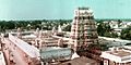
The Veera Raghava Swami Temple in Tiruvallur
See also
 In Spanish: Distrito de Tiruvallur para niños
- List of districts of Tamil Nadu
- Thiruthaleeshwarar Temple
