Tomichi Dome facts for kids
Quick facts for kids Tomichi Dome |
|
|---|---|

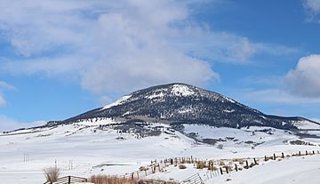
Tomichi Dome viewed from U.S. Route 50
|
|
| Highest point | |
| Elevation | 11,471 ft (3,496 m) |
| Prominence | 2,325 ft (709 m) |
| Isolation | 10.74 mi (17.28 km) |
| Listing | Colorado prominent summits |
| Geography | |
| Location | Gunnison County, Colorado, U.S. |
| Parent range | Sawatch Range |
| Topo map | USGS 7.5' topographic map Doyleville, Colorado |
Tomichi Dome is a striking mountain located in Gunnison County, Colorado. It stands proudly north of U.S. Highway 50, west of Hot Springs Creek. You can find it south of Waunita Hot Springs Reservoir. This impressive peak is part of the beautiful Gunnison National Forest.
Contents
How Tomichi Dome Formed: A Look at its Geology
Tomichi Dome is a special kind of mountain made from igneous rock. This means it was formed from melted rock (magma or lava) that cooled down. It was created a long, long time ago during a period called the Tertiary period.
The Rocks of Tomichi Dome
The main type of rock here is called rhyolite. This is a fine-grained volcanic rock. Scientists have also found other rocks like microgranite, breccia, and tuff. Breccia is made of broken rock pieces cemented together. Tuff is rock formed from volcanic ash.
Around the base of the mountain, in the valley, you'll find Mancos Shale. This is a sedimentary rock from the Mesozoic Era. Sedimentary rocks form from layers of mud, sand, or other materials over time.
Two Ideas: Intrusion or Extrusion?
Geologists have two main ideas about how Tomichi Dome formed.
Idea 1: An Underground Intrusion
One idea is that Tomichi Dome is an intrusion. This means it formed when hot magma pushed its way into the existing Mancos Shale rock layers underground. This might have created a dome-shaped rock body called a laccolith.
Because the rock is fine-grained, scientists think the magma cooled quickly. This suggests it was not very deep underground. Sometimes, these intrusions can also cause volcanic vents, which might explain the breccia and tuff found nearby. Similar laccoliths are found in the San Juan Mountains not too far away.
Idea 2: A Volcanic Eruption
The second idea is that Tomichi Dome is an extrusive, volcanic feature. This means it formed from lava and ash erupting onto the surface. In this scenario, the first eruptions would have laid down thick layers of breccia and tuff. These layers can be over 670 feet (200 meters) thick! After that, a flow or dome of topaz rhyolite rock covered the tuff.
Part of a Bigger Picture
No matter how it formed, Tomichi Dome is likely connected to a series of similar rock structures. These structures are part of the Rio Grande Rift. This is a huge crack in the Earth's crust that stretches all the way from Mexico to Colorado.
Historical Names
- Tomichi Dome – This name was officially used starting in 1907.
- Tumitche Dome – This was another name used in the past.
 | Jessica Watkins |
 | Robert Henry Lawrence Jr. |
 | Mae Jemison |
 | Sian Proctor |
 | Guion Bluford |


