
Trade route facts for kids

A trade route is like a special path or road that people use to move goods and products from one place to another for buying and selling. Think of it as a highway for cargo! These routes are super important because they help different places connect and share what they have.
Historically, people have been using trade routes for thousands of years. From about 1500 BC to 1 AD, big societies in places like Western Asia, the Mediterranean Sea, China, and India started building huge networks for trade. One of the most famous was the Silk Road, which connected the East and West. In Europe, an early route was the amber road, used for trading amber over long distances.
During the Middle Ages, trading by sea became very popular, especially along the Spice Route. Nations even tried to control these important sea paths because they brought so much wealth and power. Groups like the Hanseatic League also became important. They worked to protect merchants and make sure trade was safe and fair.
Modern Trade Routes
In more recent times, how we trade has changed a lot. Instead of just using old routes, trade now happens between modern countries. Sometimes, this trade happens under special agreements called free trade agreements. These agreements make it easier for goods to cross borders without many rules or taxes.
Today, we have many new ways to transport goods. We use pipelines for liquids and gases, and of course, trains are very common. Trucks on roads and cargo airlines flying through the sky also move tons of goods every day. These modern methods make trade faster and easier than ever before.
Images for kids
-
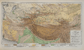
Map of Central Asia with its trade routes and movements between 128 BC to 150 AD
-
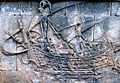
One of the Borobudur ships from the 8th century. These were pictures of large native outrigger trading vessels, possibly from the Sailendra and Srivijaya thalassocracies. They show the special tanja sail of Southeast Asian Austronesians.
-
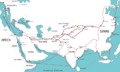
Trading routes used around the 1st century CE, with the Silk Road as a main path.
-
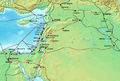
The Via Maris (purple), King's Highway (red), and other ancient Levantine trade routes, around 1300 BCE.
-
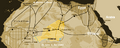
Saharan trade routes around 1400. The modern country of Niger is highlighted. Tuareg people had a lot of influence over the Trans-Saharan Trade.
-
Austronesian early historic and historic sea trade network in the Indian Ocean.
-
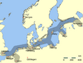
Main trading routes of the Hanseatic League.
-
Genoese (red) and Venetian (green) sea trade routes in the Mediterranean.
-
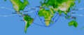
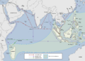
Portuguese India Armadas and trade routes (blue) since Vasco da Gama's journey in 1498. Also, the Spanish Manila-Acapulco galleons trade routes (white) started in 1568.
-
Map of the Maritime Silk Road.
-
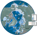
Map of the Arctic region showing the Northeast Passage, the Northern Sea Route within it, and the Northwest Passage.
-
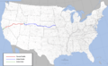
Route of the first American transcontinental railroad from Sacramento, California, to Council Bluffs, Iowa.
-
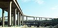
A large freeway interchange in Los Angeles, California.
-
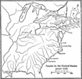
Canals in the US around 1825.
-
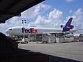
A FedEx DC-10 airplane.
-
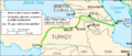
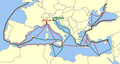
Route of the Baku-Tbilisi-Ceyhan pipeline.


See also
 In Spanish: Ruta comercial para niños
