Northeast Passage facts for kids
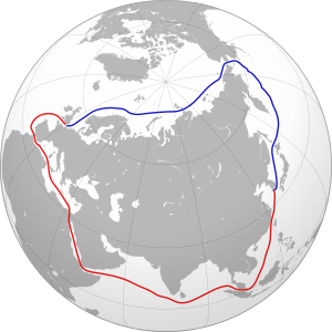
The Northeast Passage (often called NEP) is a shipping route that goes along the Arctic coasts of Norway and Russia. From Europe and the northern Atlantic Ocean, it's a way to reach the Pacific Ocean. A similar route through the Canadian islands is called the Northwest Passage.
The NEP crosses several seas as it goes from west to east: the Barents Sea, Kara Sea, Laptev Sea, East Siberian Sea, and Chukchi Sea. It also includes a part called the Northern Sea Route (NSR). The Northern Sea Route is a specific section of the NEP defined by Russian law. It doesn't include the Barents Sea, so it doesn't reach the Atlantic Ocean. However, because the NSR covers most of the NEP, people sometimes use "Northern Sea Route" to mean the whole Northeast Passage. This can be a bit confusing!
The Northeast Passage is one of several important routes in the Arctic. Others include the Northwest Passage (which goes through Canada's Arctic islands) and the Transpolar Sea Route (which crosses right over the North Pole).
The first time someone successfully sailed the entire Northeast Passage, from west to east, was in 1878–79. This was done by the Swedish-Finnish explorer Adolf Erik Nordenskiöld on a Swedish ship called Vega. King Oscar II of Sweden helped fund his journey. Nordenskiöld's ship had to stop for the winter very close to the Bering Strait because of thick ice.
Contents
History of the Northeast Passage
Early Explorers: 11th to 17th Centuries
People first wanted to find the Northeast Passage for economic reasons. They hoped it would be a faster way to trade with Asia. In Russia, the idea of a sea route connecting the Atlantic and Pacific Oceans was first suggested in 1525 by a diplomat named Dmitry Gerasimov. However, Russian settlers and traders called the Pomors had already been exploring parts of this route as early as the 11th century.
In 1553, an English explorer named Hugh Willoughby sailed across the Barents Sea looking for the Northeast Passage. He thought he saw islands to the north. These islands, called Willoughby's Land, even appeared on maps by famous mapmakers like Petrus Plancius and Gerardus Mercator in the 1590s.
By the 1600s, traders had created a continuous sea route from Arkhangelsk to the Yamal Peninsula. From there, they would carry their goods over land to the Gulf of Ob. This route was known as the Mangazeya seaway, named after a trade town called Mangazeya. It was an early version of the Northern Sea Route.
East of the Yamal Peninsula, sailing north of the Taimyr Peninsula was very difficult or impossible. However, from the 1630s, Russians started sailing along the Arctic coast from the Lena River to beyond the Kolyma River. While Vitus Bering (in 1728) and James Cook (in 1778) sailed into the Bering Strait from the south, no one is recorded as sailing eastward between the Kolyma River and the Bering Strait from 1648 (Semyon Dezhnev) until 1879 (Adolf Erik Nordenskiöld).
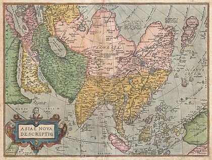
Western European countries like England, the Netherlands, Denmark, and Norway also explored the western parts of the passage. They were looking for a new sea route to China and India. These expeditions didn't find the full passage, but they did discover new coasts and islands. A famous expedition was in 1596, led by the Dutch navigator Willem Barentsz. He discovered Spitsbergen and Bear Island, and sailed around the northern tip of Novaya Zemlya.
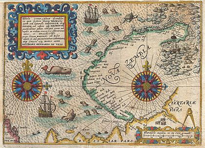
Russia worried about English and Dutch ships entering Siberia. So, in 1619, Russia closed the Mangazeya seaway. The Pomor people's trading activities in Northern Asia decreased. Most Arctic exploration in the 1600s was then done by Siberian Cossacks. They sailed from one river mouth to another in their strong boats called kochs. In 1648, the most famous of these trips was led by Fedot Alekseev and Semyon Dezhnev. They sailed east from the mouth of the Kolyma River to the Pacific Ocean, going around the Chukchi Peninsula. This proved that Asia and North America were not connected by land.
More Explorations: 18th and 19th Centuries
Eighty years after Dezhnev, in 1728, another Russian explorer named Vitus Bering (who was Danish-born) made a similar journey in reverse. He started in Kamchatka and sailed north to the passage that is now named after him: the Bering Strait. Bering also named the Diomede Islands, which Dezhnev had mentioned.
Bering's explorations from 1725 to 1730 were part of a bigger plan by Peter the Great, known as the Great Northern Expedition.
The Second Kamchatka Expedition happened from 1735 to 1742. It involved two ships, Svyatoy Pyotr (Saint Peter) and Svyatoy Pavel (Saint Paul). Bering commanded the first ship, and his deputy, Captain Aleksei Chirikov, commanded the second. During this expedition, Bering was the first Westerner to see the coast of northwestern North America. Chirikov was the first Westerner to land there after a storm separated the two ships. On his way back, Bering discovered the Aleutian Islands but became ill and died on an island off Kamchatka, which is now called Bering Island.
Other Russian Imperial Navy groups also took part in the Second Great Northern Expedition. One of them, led by Semyon Chelyuskin, reached Cape Chelyuskin in May 1742. This is the northernmost point of both the Northeast Passage and the continent of Eurasia.
Later expeditions to explore the Northeast Passage happened in the 1760s (Vasily Chichagov), 1785–95 (Joseph Billings and Gavril Sarychev), and the 1820s and 1830s (Baron Ferdinand von Wrangel, Pyotr Fyodorovich Anjou, Fyodor Petrovich Litke, and others). By the mid-1800s, it was clear that it was possible to sail the entire length of the passage.
However, it was only in 1878-79 that the Fenno-Swedish explorer Adolf Erik Nordenskiöld made the first complete journey through the Northeast Passage, sailing from west to east. This was called the Vega expedition. The ship's captain was Lieutenant Louis Palander of the Swedish Royal Navy.
One year before Nordenskiöld's journey, commercial use of a part of the route began. These were called Kara expeditions, which exported farm products from Siberia through the Kara Sea. Between 1877 and 1919, out of 122 groups of ships, only 75 were successful. They carried only about 55 tons of goods. From 1911, steamboats on the Kolyma River sailed from Vladivostok to the Kolyma once a year.
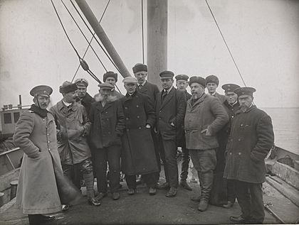
In 1912, two Russian expeditions set out: Captain Georgy Brusilov on the Santa Anna and Captain Alexander Kuchin with Vladimir Rusanov on the Gerkules (Hercules). Both expeditions had a woman on board, were quickly put together, and both disappeared. A German Arctic Expedition in 1912, led by Herbert Schröder-Stranz, also ended badly, with only 7 of 15 crew members surviving.
In 1913, Jonas Lied organized a successful expedition through the Kara Sea to the Yenisei River. The famous explorer and scientist Fridtjof Nansen and Siberian businessman Stephan Vostrotin were important passengers. Lied had started "The Siberian Company" to export and import goods using the big Siberian rivers and the Kara Sea. Nansen wrote about the 1913 trip in his book Through Siberia.
In 1915, a Russian expedition led by Boris Vilkitskiy made the passage from east to west using the icebreakers Taymyr and Vaygach.
Many other explorers like Nordenskiöld, Nansen, Amundsen, DeLong, and Stepan Makarov also led expeditions. Their main goals were scientific research and making maps.
After the Russian Revolution
After the Russian Revolution of 1917, the Soviet Union was separated from Western countries. This made using the Northern Sea Route very important. New technologies like radio, steamboats, and icebreakers made the route possible. It was the shortest sea route between the western and far eastern parts of the USSR. It was also the only one that was completely within Soviet waters, so it didn't involve other countries.
In 1932, a Soviet expedition on the icebreaker A. Sibiryakov, led by Professor Otto Yulievich Schmidt, was the first to sail all the way from Arkhangelsk to the Bering Strait in one summer without stopping for winter. After some test runs in 1933 and 1934, the Northern Sea Route was officially opened, and commercial shipping began in 1935. The next year, part of the Baltic Fleet used the passage to reach the Pacific Ocean, as a conflict with Japan seemed likely.
A special group called Glavsevmorput (Chief Directorate of the Northern Sea Route) was created in 1932, with Otto Schmidt as its head. This group managed shipping and built ports in the Arctic.
During the early part of World War II, the Soviets allowed the German ship Komet to use the Northern Sea Route in the summer of 1940. This helped it avoid the British Royal Navy and get into the Pacific Ocean. Soviet icebreakers helped Komet on its journey. After the war between the Soviets and Germany began, the Soviets also moved several destroyers from their Pacific Fleet to their Northern Fleet using the Arctic route.
In July 1965, the US Coast Guard ship Northwind (USCGC Northwind (WAGB-282)) explored the ocean between Greenland, Iceland, and Scotland. It was the first Western ship to operate in the Kara Sea of the Soviet Union. Its secret mission was to try to travel the "Northeast Passage," but this attempt was not successful due to political reasons.
After the Soviet Union
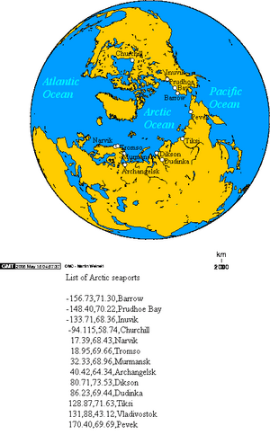
After the Soviet Union broke up in the early 1990s, commercial shipping in the Siberian Arctic decreased a lot. Regular shipping now mostly happens only from Murmansk to Dudinka in the west and between Vladivostok and Pevek in the east. Many ports between Dudinka and Pevek are now ghost towns with almost no shipping activity.
However, interest in the route grew again, leading to several test voyages in 1997, including the Finnish oil tanker Uikku.
A news report in January 2013 said that shipping traffic on the Northern Sea Route grew a lot in 2012, carrying about 1 million tons of goods. But this was still much less than the peak of 6.6 million tons in 1987. The report also mentioned that the Finnish oil tanker Uikku was the first non-Russian energy ship to use the route in 1997.
Northern Sea Route
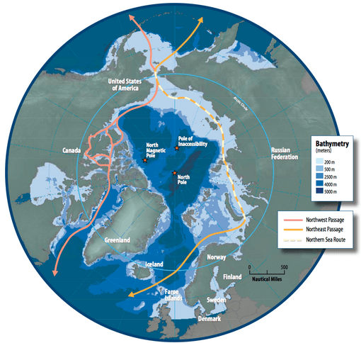
The Northern Sea Route (NSR) is a route similar to the NEP. Russian law defines the NSR as stretching from the Novaya Zhelaniya straits (near the Novaya Zemlya islands, connecting the Barents Sea to the west and the Kara Sea to the east) to Cape Dezhnev near the Bering Strait. So, the NEP includes all the East Arctic seas, while the NSR includes all these seas except the Barents Sea. Since the NSR makes up most of the NEP, sometimes the term NSR is used to refer to the entire NEP.
Managing the Route
How the Northeast Passage is managed has changed a lot since the late 1900s. The main rules and agreements come from the United Nations Convention on the Law of the Sea (UNCLOS), the Arctic Council (AC), the International Maritime Organization (IMO), and Russia's own laws. Together, these cover who owns what land, how to use resources, what ships need to do, how to protect the environment, and who is responsible for search and rescue missions.
Distances Across the Pacific and Atlantic
The Northeast Passage is a shorter way to connect Northeast Asia with Western Europe compared to routes through the Suez Canal, the Panama Canal, or around the Cape of Good Hope. The table below shows how far it is between major East Asian ports and Rotterdam in Europe. These distances assume there are no changes to the route because of ice.
| To Rotterdam, via: | ||||
|---|---|---|---|---|
| From | Cape of Good Hope | Suez Canal | NEP | Difference between Suez and NEP |
| Yokohama, Japan | 14,448 | 11,133 | 7,010 | 37% |
| Busan, South Korea | 14,084 | 10,744 | 7,667 | 29% |
| Shanghai, China | 13,796 | 10,557 | 8,046 | 24% |
| Hong Kong, China | 13,014 | 9,701 | 8,594 | 11% |
| Ho Chi Minh City, Vietnam | 12,258 | 8,887 | 9,428 | −6% |
Commercial Value of the Route
If the Northern Sea Route can be used reliably between northern Europe and North Pacific ports, it would cut sailing time (and fuel use) by more than half. For companies that ship large amounts of raw materials, saving money on fuel could be a big reason to use the Northern Sea Route. This route also allows for economies of scale, meaning larger ships can be used compared to coastal routes. Environmental rules for shipping might also encourage the use of the Northern Sea Route. Knowing the environmental benefits and costs of both the Northern Sea Route and the Suez Canal routes will likely be important for future decisions.
In 2011, four ships sailed the entire Northern Sea Route and Northeast Passage, from the Atlantic to the Pacific Oceans. In 2012, 46 ships used the Northern Sea Route.
In August 2012, Russian news reported that 85% of ships using the Northern Sea Route in 2011 were carrying gas or oil. Also, 80% were large tankers.
Environmental Concerns
In September 2012, Jimmy Stotts, who leads the Inuit Circumpolar Council, said that there are worries that more shipping could harm the hunting of marine mammals by indigenous people. There are also concerns about the lack of facilities on the Western Alaska coast to handle an oil spill or a wrecked ship.
Ice Conditions
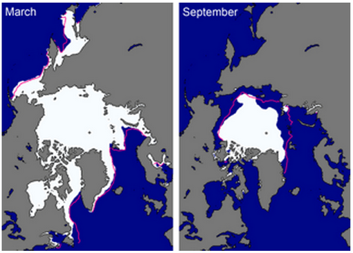
Unlike similar areas in Alaska and Canada (along the Northwest Passage), some parts of the Northeast Passage stay free of ice all year. This is mostly true for the Barents Sea, near the northern coast of Norway and the northwestern coast of Russia. The Barents Sea is warmed by currents from the Gulf Stream, which brings warm water into the North Atlantic.
Other parts of the Northeast Passage (mostly the NSR section) freeze in winter and partly melt in the summer months, especially along the coasts. Since the early 2000s, the summer melting has been stronger, and the winter freezing has been weaker. This means more ships that aren't icebreakers can use the route for longer periods.
Ports Without Ice
Only one Russian seaport in the Barents Sea along the official Northern Sea Route (which starts at the Kara Gates Strait) is ice-free all year. This is Murmansk on the Kola Peninsula. Other Arctic ports can usually be used from July to October, or they are served by nuclear-powered icebreakers, like Dudinka. Beyond the Bering Strait, at the end of the Northern Sea Route, and south along Russia's Pacific coast, ports like Petropavlovsk in Kamchatka, Vanino, Nakhodka, and Vladivostok are open all year.
Shipping Activity
Because of its harsh weather and low population, the Northeast Passage has not seen much shipping activity. The NSR part of the NEP was busiest during the time of the USSR. The NSR grew a lot as a route supported by the government, with traffic reaching its highest point in 1987. At that time, 331 ships carried 6.58 million tons of goods over 1306 trips. When the Soviet Union ended and government support stopped, NSR traffic dropped to 1.5–2 million tons of goods.
Since the early 2000s, the Arctic sea ice has become much thinner and covered a smaller area than average. This has led to more shipping. In 2011, four ships sailed the entire NEP. In 2012, 46 ships did, and in 2013, 19 ships. The number of trips is still very small compared to the thousands of ships that go through the Suez Canal each year. Most large container ships are expected to keep using the Suez route. However, specialized shipping, like carrying bulk goods, is expected to grow, driven by mining in the Arctic.
Sailing Through Ice-Free Areas
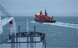
When people say "ice free," it usually means there is no fast ice, which is a continuous sheet of frozen surface ice. "Ice free" doesn't mean there's no Arctic sea ice at all. These "ice free" areas can still have broken ice that varies in how thick it is. Ships often still need strong hulls or help from an icebreaker to pass safely.
In the summer of 2002, French sailor Eric Brossier made the first passage by sailboat in just one season. He returned to Europe the next summer through the Northwest Passage.
The same year, Arved Fuchs and his crew sailed the Northeast Passage with their ship, the Dagmar Aaen.
The Northern Sea Route became open due to melting ice in 2005 but closed again by 2007. The amount of polar ice returned to 2005 levels in August 2008. In late August 2008, it was reported that satellite images showed the last ice blocking the Northern Sea Route in the Laptev Sea had melted. This would have been the first time since satellites started recording that both the Northwest Passage and Northern Sea Route were open at the same time. However, other scientists thought the satellite images might have been misunderstood, and the route was not yet fully passable.
In 2009, the Bremen-based Beluga Group claimed they were the first Western company to try crossing the Northern Sea Route for shipping without help from icebreakers. This would cut 4000 nautical miles off the journey between Ulsan, Korea and Rotterdam. This journey was widely reported, and sometimes it was wrongly said to be the first time non-Russian ships made the trip. In 1997, a Finnish oil tanker, Uikku, sailed the length of the Northern Sea Route from Murmansk to the Bering Strait, becoming the first Western ship to complete the voyage.
However, in August 2009, the new (2008) ice-strengthened ships Beluga Fraternity and Beluga Foresight started an East-to-West journey through the Northern Sea Route. They were part of a small group of ships helped by the Russian nuclear icebreaker NS 50 Let Pobedy. The two ships took on Russian ice pilots for the trip to the western Siberian port of Novyy. The ships arrived at Novyy on September 7, unloaded their cargo, and left on September 12 for the Kara Gates and Rotterdam. They were the first non-Russian commercial ships to complete this journey, but they did have Russian help. The captain of the Beluga Foresight, Valeriy Durov, called it "great news for our industry." The president of Beluga Shipping said the trip saved each ship about 300,000 euros compared to the usual Korea-to-Rotterdam route through the Suez Canal. The company did not say how much they paid for the icebreaker escort and the Russian pilots. A press release on September 18, 2009, stated that the company planned for six ships to make Arctic deliveries in 2010. It's not clear if this plan was fully carried out.
In 2009, the first two international commercial cargo ships traveled north of Russia between Europe and Asia. In 2011, 18 ships made the now mostly ice-free journey. During 2011, 34 ships made the trip, up from 6 ships in 2010. In 2012, 46 commercial ships made the journey. Oil and gas products were the largest type of cargo. In 2013, 71 commercial ships made the trip.
On July 28, 2009, the sailing yacht RX II (36 feet long), with expedition leader Trond Aasvoll and crew Hans Fredrik Haukland and Finn Andreassen, left Vardø in Norway. Their goal was to sail around the North Pole. The northern sea route was ice-free, and the three Norwegians sailed into the Bering Strait on September 24. But Russian rules stopped their attempt to sail around in one season. The boat spent the winter in Nome and finished the trip through the Northwest Passage the following summer.
Also in 2009, Ola Skinnarmo and his crew sailed the Northeast Passage aboard Explorer of Sweden. They were the second Swedish sailboat to travel the Northeast Passage, after Adolf Erik Nordenskiöld.
In September 2010, two yachts sailed around the Arctic: Børge Ousland's team on The Northern Passage, and Sergei Murzayev's team on the Peter I. These were the first times sailing yachts were recorded completing a full circle around the Arctic in one season.
As of 2011, the largest ship to use the route was the 117,000-ton SCF Baltica, carrying natural-gas condensate.
In 2012, the 288-meter (945 ft) LNG carrier Ob River became the first ship of its kind to travel the Northern Sea Route. The ship completed the westbound journey without cargo in only six days. It planned to sail back to Asia in November with a full load of liquified natural gas. The increase in traffic has been surprising. 46 ships sailed the entire length from Europe to East Asia during 2012. By July 2013, the people managing the Northern Sea Route had given permission to 204 ships to sail during the season. By that time, Arctic sea ice had decreased a lot, especially on the Atlantic side of the Arctic. (The amount of Arctic sea ice in the summer of 2012 reached a record low.)
In early September 2013, the Russian battlecruiser Petr Velikiy led a group of Russian navy ships with icebreaker support along the Northern Sea Route to the New Siberian Islands. About 400 ships were expected to use the Russian part of the route during the 2013 season, which was a big jump from about 40 in 2012.
On September 15, 2015, the Chinese trimaran Qingdao China set a speed record by sailing from Murmansk to the Bering Strait in 13 days.
On October 3, 2019, Nanni Acquarone became the first Italian skipper with the Italian cutter Best Explorer to sail both the Northwest Passage (in 2012) and the Northeast Passage (clockwise) with a sailboat. Best Explorer started on June 1, 2012, from Tromsø (Norway), sailing the Northwest Passage (the first Italian boat and skipper to do so). After several years of sailing in the Pacific, it got permission to follow the Northeast Passage without help and without a Russian person on board. The crew had 5 people, including Salvatore Magri, who had sailed the Northwest Passage with Nanni. In 2019, Best Explorer left Petropavlovsk Kamchatski on August 3, crossed the Bering Strait on August 19, and reached Murmansk on September 22.
Remembering the Route
In 2007, Finland released a special €10 gold and silver coin to celebrate the 175th anniversary of Nordenskiöld's birth and his discovery of the northern sea route. One side of the coin shows a picture of Nordenskiöld steering his ship. The other side has a pattern that looks like the maze created by ice floes. This coin is part of the Europa Coins 2007 series, which celebrates European achievements in history.
|
See also
 In Spanish: Ruta marítima del Norte para niños
 | Claudette Colvin |
 | Myrlie Evers-Williams |
 | Alberta Odell Jones |


