
Bering Island facts for kids
|
Native name:
Behring Island
|
|
|---|---|

Bering Island from space, March 1992
|
|
| Geography | |
| Location | Bering Sea |
| Coordinates | 55°0′3″N 166°16′23″E / 55.00083°N 166.27306°E |
| Administration | |
|
Russia
|
|
| Oblast | Kamchatskaya |
| City | Nikolskoye |
Bering Island (Russian: о́стров Бе́ринга, ostrov Beringa) is a large island located near the Kamchatka Peninsula in the Bering Sea. It is the biggest and westernmost of the Commander Islands. The island is about 90 kilometers (56 miles) long and 24 kilometers (15 miles) wide. Its total area is about 1,660 square kilometers (641 square miles).
Bering Island is a wild place with no trees. It often has strong winds, thick fog, and even earthquakes. For a long time, no one lived there all year round. Today, about 800 people live in the village of Nikolskoye. Around 300 of these residents are Aleuts. Most people on the island work in fishing.
A small island called Toporkov Island is located about 4 kilometers (2.5 miles) off Bering Island's northwest coast. It is a round island, about 800 meters (2,600 feet) across.
Contents
Island History: Discovering Bering Island
Bering Island was first discovered in 1741 by Commander Vitus Bering. He was sailing for the Russian Navy on a ship called Svyatoy Pyotr (which means St. Peter). His expedition had just discovered mainland Alaska and the Aleutian Islands.
On their way back, storms badly damaged their ship. They were shipwrecked on Bering Island. Commander Bering and 28 of his crew members sadly died there from scurvy, a disease caused by a lack of vitamin C.
Survival and Exploration on Bering Island
The remaining crew, led by a Swedish lieutenant named Sven Waxell, were stuck on the island for 10 months. They survived by hunting seals and birds. They were very resourceful and managed to build a new boat from the parts of their wrecked ship. In 1742, they sailed back to Petropavlovsk on the Kamchatka Peninsula. They brought back valuable sea otter furs and preserved meat from the island.
Another survivor of the expedition was Georg Wilhelm Steller. He was a German naturalist, someone who studies nature. Steller helped his companions by convincing them to eat seaweed, which helped cure their scurvy. He explored Bering Island and studied its animals. He found a huge, gentle sea creature called Steller's sea cow. Sadly, this animal became extinct within 30 years because people hunted it for its meat.
Today, the highest point on Bering Island, which is about 751 meters (2,464 feet) tall, is named after Steller. After returning to Russia, Steller wrote a famous book called De Bestiis Marinis (On the Beasts of the Sea).
Early Settlements and People
In 1743, a hunter named Emilian Basov came to Bering Island to hunt sea otters. This marked the beginning of human activity on the island. Hunters, called Promyshlenniki, then started moving from island to island across the Bering Sea, eventually reaching the Aleutian Islands and Alaska.
In 1825, the Russian-American Company brought Aleut families from Attu Island to Bering Island to hunt. More Aleut and mixed-race settlers arrived the next year. This was the first time people lived on Bering Island permanently.
After Russia sold Alaska and the Aleutian Islands to the United States in 1867, Bering Island became part of the Petropavlovsk-Kamchatsky area. The island's population grew over time. In 1827, there were 110 people. By 1879, there were over 300 people, including many Aleuts and people of mixed heritage.
In 1990, something special happened. After 170 years of being separated, Aleuts from Nikolskoye met Aleuts from Alaska. They were amazed that they could still talk to each other in the old Aleut language!
Island Nature: Wildlife and Environment
The area around Bering Island is now a special nature reserve called Komandorsky Zapovednik. It is known for its many different kinds of wildlife, especially marine mammals (animals that live in the sea).
Marine Animals of Bering Island
The shores of Bering Island are a natural home for sea otters. Their population is now healthy, even though they were hunted almost to extinction by 1854. Large Steller sea lions still come to Bering Island in the summer.
Bering Island has also been famous for its seal colonies. These include northern fur seals, common seals, and larga seals. Sadly, hunting greatly reduced their numbers in the past.
Many types of whales are seen in the waters around Bering Island. These include sperm whales, orcas (killer whales), different kinds of beaked whales, humpback whales, and right whales. Small sea mammals called Porpoises also swim in these waters.
Birds and Other Wildlife
Bering Island is home to many seabirds. Over 200 bird species have been seen on the Commander Islands, and 58 of them nest there. Puffins are very common. However, a large, flightless bird called the spectacled cormorant became extinct around 1850.
Two types of Arctic foxes, which caused trouble for Bering's crew long ago, still live on the island. Humans also brought other animals like reindeer, American mink, and rats to the islands. These new animals have sometimes caused problems for the native wildlife.
Island Climate: Weather on Bering Island
Bering Island has a subarctic climate. This means it has long, cold winters and short, cool summers. However, because it's an island surrounded by the ocean, the temperatures are not as extreme as in places far inland in Siberia. Winters are about four degrees Celsius (seven degrees Fahrenheit) milder than in Petropavlovsk-Kamchatsky.
The island often has a lot of fog. This is because of weather patterns from the Aleutian Low and the cold Oyashio Current. Because of the fog, Bering Island gets very little sunshine, only about 2.8 hours per day on average.
The temperature on Bering Island has ranged from a very cold -23.5 degrees Celsius (-10.3 degrees Fahrenheit) to a warm 21.5 degrees Celsius (70.7 degrees Fahrenheit).
| Climate data for Bering Island (1899-2018) (Climate ID:32618) | |||||||||||||
|---|---|---|---|---|---|---|---|---|---|---|---|---|---|
| Month | Jan | Feb | Mar | Apr | May | Jun | Jul | Aug | Sep | Oct | Nov | Dec | Year |
| Record high °C (°F) | 5.4 (41.7) |
5.1 (41.2) |
8.8 (47.8) |
10.2 (50.4) |
13.6 (56.5) |
21.5 (70.7) |
21.4 (70.5) |
21.0 (69.8) |
18.5 (65.3) |
12.7 (54.9) |
9.2 (48.6) |
7.4 (45.3) |
21.5 (70.7) |
| Mean maximum °C (°F) | 2.4 (36.3) |
2.0 (35.6) |
3.1 (37.6) |
4.7 (40.5) |
8.7 (47.7) |
12.6 (54.7) |
17.0 (62.6) |
17.1 (62.8) |
14.9 (58.8) |
10.8 (51.4) |
6.6 (43.9) |
3.4 (38.1) |
18.3 (64.9) |
| Mean daily maximum °C (°F) | −2 (28) |
−1.9 (28.6) |
−0.9 (30.4) |
1.1 (34.0) |
4.3 (39.7) |
7.7 (45.9) |
10.7 (51.3) |
12.5 (54.5) |
11.2 (52.2) |
7.2 (45.0) |
2.5 (36.5) |
−0.7 (30.7) |
4.3 (39.7) |
| Daily mean °C (°F) | −3.5 (25.7) |
−3.4 (25.9) |
−2.4 (27.7) |
−0.3 (31.5) |
2.5 (36.5) |
5.7 (42.3) |
9.0 (48.2) |
10.9 (51.6) |
9.5 (49.1) |
5.6 (42.1) |
1.0 (33.8) |
−2.2 (28.0) |
2.7 (36.9) |
| Mean daily minimum °C (°F) | −5.5 (22.1) |
−5.3 (22.5) |
−4.3 (24.3) |
−1.8 (28.8) |
1.1 (34.0) |
4.3 (39.7) |
7.7 (45.9) |
9.6 (49.3) |
7.9 (46.2) |
3.7 (38.7) |
−0.8 (30.6) |
−4.1 (24.6) |
1.0 (33.9) |
| Mean minimum °C (°F) | −11.5 (11.3) |
−11.9 (10.6) |
−10.2 (13.6) |
−5.9 (21.4) |
−1.2 (29.8) |
1.7 (35.1) |
5.5 (41.9) |
7.0 (44.6) |
4.2 (39.6) |
−0.7 (30.7) |
−5.7 (21.7) |
−9.2 (15.4) |
−13.0 (8.6) |
| Record low °C (°F) | −21 (−6) |
−23.5 (−10.3) |
−21.9 (−7.4) |
−13.9 (7.0) |
−9.6 (14.7) |
−2.3 (27.9) |
−0.5 (31.1) |
−0.1 (31.8) |
−2.9 (26.8) |
−8.5 (16.7) |
−15.4 (4.3) |
−19.9 (−3.8) |
−23.5 (−10.3) |
| Average precipitation mm (inches) | 62 (2.4) |
56 (2.2) |
48 (1.9) |
45 (1.8) |
37 (1.5) |
31 (1.2) |
39 (1.5) |
63 (2.5) |
63 (2.5) |
86 (3.4) |
83 (3.3) |
66 (2.6) |
679 (26.8) |
| Average precipitation days (≥ 1.0 mm) | 13.8 | 12.7 | 11.4 | 9.6 | 7.7 | 6.2 | 7.6 | 10.4 | 10.8 | 14.2 | 15.0 | 15.1 | 134.5 |
| Mean monthly sunshine hours | 31.0 | 56.5 | 99.2 | 120.0 | 102.3 | 84.0 | 74.4 | 108.5 | 123.0 | 111.6 | 54.0 | 27.9 | 992.4 |
| Source 1: Roshydromet | |||||||||||||
| Source 2: allmetsat.com (sunshine only) | |||||||||||||
Images for kids
-
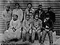
Group of Aleut hunters from Bering Island. 1884–1886.
-
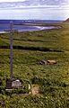
The grave of Vitus Bering
-
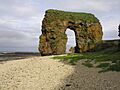
Steller's Arch


See also
 In Spanish: Isla de Bering para niños
