
Treviso facts for kids
Quick facts for kids
Treviso
|
|
|---|---|
| Città di Treviso | |

Piazza dei Signori.
|
|
.svg)
The comune Treviso, in red, in the province.
|
|
| Country | Italy |
| Region | Veneto |
| Province | Treviso (TV) |
| Area | |
| • Total | 55.58 km2 (21.46 sq mi) |
| Elevation | 15 m (49 ft) |
| Highest elevation | 31 m (102 ft) |
| Lowest elevation | 6 m (20 ft) |
| Population
(1 January 2016)
|
|
| • Total | 83,731 |
| • Density | 1,506.50/km2 (3,901.8/sq mi) |
| Demonym(s) | Trevigiani or Trevisani |
| Time zone | UTC+1 (CET) |
| • Summer (DST) | UTC+2 (CEST) |
| Postal code |
31100
|
| Dialing code | 0422 |
| Patron saint | St. Liberalis |
| Saint day | 27 April |
Treviso is a beautiful city in the Veneto region of Northeast Italy. It is the main city, or capital, of the province that shares its name. Treviso is located about 30 km (19 mi) north of Venice, which is the capital city of the Veneto region.
Contents
Where is Treviso?
Treviso is located where two rivers, the Botteniga and the Sile, meet. It is about 30 kilometres (19 miles) north of Venice. The city is also 50 km (31 mi) east of Vicenza and 40 km (25 mi) northeast of Padua. If you travel south from Cortina d'Ampezzo, it's about 120 km (75 mi) away.
The city sits on a flat area, or plain, near the Piave river. This plain is found between the Gulf of Venice (part of the Adriatic Sea) and the tall Alps mountains.
The area of Treviso is about 55.58 km2 (21.46 sq mi). It is about 15 m (49 ft) above sea level.
Treviso shares its borders with several other towns. These include Carbonera, Casier, Paese, Ponzano Veneto, Preganziol, Quinto di Treviso, Silea, Villorba, and Zero Branco.
Treviso's Weather
Treviso has a type of weather called an oceanic climate. This means it has warm summers. In the Köppen climate classification, this is known as Cfb.
The average temperature in Treviso for the whole year is 13 °C (55 °F). The warmest month is usually July, with an average temperature of 22.9 °C (73.2 °F). January is the coolest month, averaging 2.7 °C (36.9 °F).
On average, Treviso gets about 927.1 mm (36.5 in) of precipitation (rain or snow) each year. June is typically the wettest month, with about 104.1 mm (4.1 in) of precipitation. February is usually the driest month, receiving about 63.5 mm (2.5 in).
| Climate data for Treviso, Italy | |||||||||||||
|---|---|---|---|---|---|---|---|---|---|---|---|---|---|
| Month | Jan | Feb | Mar | Apr | May | Jun | Jul | Aug | Sep | Oct | Nov | Dec | Year |
| Mean daily maximum °C (°F) | 6.5 (43.7) |
9.1 (48.4) |
13.1 (55.6) |
17.4 (63.3) |
22.3 (72.1) |
25.8 (78.4) |
28.4 (83.1) |
27.9 (82.2) |
24.5 (76.1) |
19.1 (66.4) |
12.2 (54.0) |
7.4 (45.3) |
17.8 (64.1) |
| Daily mean °C (°F) | 2.6 (36.7) |
4.8 (40.6) |
8.3 (46.9) |
12.4 (54.3) |
17.1 (62.8) |
20.6 (69.1) |
22.9 (73.2) |
22.4 (72.3) |
19.1 (66.4) |
13.9 (57.0) |
8.0 (46.4) |
3.5 (38.3) |
13.0 (55.3) |
| Mean daily minimum °C (°F) | −1.2 (29.8) |
0.6 (33.1) |
3.6 (38.5) |
7.5 (45.5) |
11.9 (53.4) |
15.4 (59.7) |
17.5 (63.5) |
16.9 (62.4) |
13.7 (56.7) |
8.8 (47.8) |
3.8 (38.8) |
−0.5 (31.1) |
8.2 (46.7) |
| Average rainfall mm (inches) | 66.7 (2.63) |
64.5 (2.54) |
70.8 (2.79) |
67.7 (2.67) |
89.5 (3.52) |
104.8 (4.13) |
65.9 (2.59) |
90.9 (3.58) |
77.5 (3.05) |
80.7 (3.18) |
86.7 (3.41) |
62.4 (2.46) |
928.1 (36.55) |
| Source: Weatherbase.com [1] | |||||||||||||
How Many People Live in Treviso?
As of January 1, 2016, there were 83,731 people living in Treviso. This means there were about 1,506.5 people living in each square kilometer of the city.
Friendship Cities
Treviso has special friendships with other cities around the world. These are called twin towns or sister cities. They work together on cultural and educational projects.
 Orléans, France
 Timișoara, Romania
 Sarasota, Florida, United States
- Caen, France
 Curitiba, Brazil
 Neuquén, Argentina
Images for kids
-
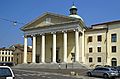
Treviso cathedral.
-
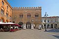
Piazza dei Signori and Palazzo dei Trecento.
-
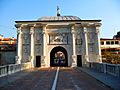
Porta San Tomaso.
-
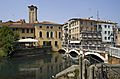
San Martino bridge on the Sile.
-
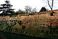
City walls.
-
A bridge on the Sile river in Treviso.


See also
 In Spanish: Treviso para niños
