Trexlertown, Pennsylvania facts for kids
Quick facts for kids
Trexlertown, Pennsylvania
|
|
|---|---|

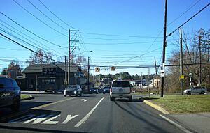
Trexlertown at the intersection of Hamilton Boulevard and Trexlertown Road
|
|

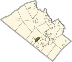
Location of Trexlertown in Lehigh County, Pennsylvania
|
|
| Country | |
| State | |
| County | Lehigh |
| Township | Upper Macungie |
| Area | |
| • Census-designated place | 2.09 sq mi (5.42 km2) |
| • Land | 2.08 sq mi (5.38 km2) |
| • Water | 0.02 sq mi (0.04 km2) |
| Elevation | 397 ft (121 m) |
| Population
(2020)
|
|
| • Census-designated place | 2,382 |
| • Density | 1,147.40/sq mi (443.06/km2) |
| • Metro | 865,310 (US: 68th) |
| Time zone | UTC-5 (Eastern (EST)) |
| • Summer (DST) | UTC-4 (EDT) |
| ZIP Code |
18087
|
| Area code(s) | 610 and 484 |
| FIPS code | 42-77488 |
| GNIS feature ID | 1189757 |
| Primary airport | Lehigh Valley International Airport |
| Major hospital | Lehigh Valley Hospital–Cedar Crest |
| School district | Parkland |
Trexlertown is a small community in Lehigh County, Pennsylvania. It is known as a census-designated place (CDP). This means it's a special area defined by the government for counting people.
Trexlertown is part of Upper Macungie Township. In 2020, about 2,382 people lived there. It's also part of the larger Lehigh Valley area. This region is home to over 860,000 people.
You can find Trexlertown between two other communities: Breinigsville and Wescosville. A big company called Air Products has its main office right next to Trexlertown. Also nearby is the Lehigh Valley Velodrome. This is a special track for professional and amateur bike racing.
Contents
History of Trexlertown
How Trexlertown Got Its Name
The story of Trexlertown began a long time ago. In 1732, a man named Jeremiah Trexler bought land. This land was in what is now Upper Macungie Township. Jeremiah Trexler opened a tavern there. A tavern was like an inn or a pub where people could eat, drink, and stay.
Two years later, in 1734, a new road was built. This road connected Trexler's tavern to Philadelphia. It passed through a place called North Wales.
It was common back then for villages to grow around important places. So, a small village started to form around Jeremiah Trexler's tavern. People began to call this new village Trexlertown. They named it after Jeremiah Trexler because he helped start it.
| Historical population | |||
|---|---|---|---|
| Census | Pop. | %± | |
| 2000 | 957 | — | |
| 2010 | 1,988 | 107.7% | |
| 2020 | 2,382 | 19.8% | |
| U.S. Decennial Census | |||
Geography and Location
Where is Trexlertown Located?
Trexlertown is in the southwestern part of Lehigh County. It sits on the edge of Upper Macungie Township. The community is about 397 feet (121 meters) above sea level.
To the southwest, Trexlertown borders Breinigsville. To the southeast, it touches Lower Macungie Township.
Major Roads and Waterways
U.S. Route 222 runs along the northern edge of Trexlertown. This road goes northeast about 3 miles (5 km) to Allentown. It also goes southwest about 30 miles (48 km) to Reading.
Pennsylvania Route 100 forms the western border of Trexlertown. This route goes north about 11 miles (18 km) to PA 309. It also goes south about 27 miles (43 km) to Pottstown.
The U.S. Census Bureau says Trexlertown covers about 2.09 square miles (5.4 square kilometers). Most of this area is land. Only a small part, about 0.02 square miles (0.04 square kilometers), is water.
Two small streams, Schaefer Run and Iron Run, meet in Trexlertown. They form Spring Creek. This creek flows southwest and joins Little Lehigh Creek. Both are part of the larger Lehigh River system.
Education in Trexlertown
Schools for Trexlertown Students
Trexlertown is part of the Parkland School District. This school district serves several communities in the area. Students living in Trexlertown attend schools within this district.
Older students, from ninth grade through twelfth grade, go to Parkland High School. This high school provides education for teenagers in the area.
See also
 In Spanish: Trexlertown para niños
 | Bessie Coleman |
 | Spann Watson |
 | Jill E. Brown |
 | Sherman W. White |


